MyTopo
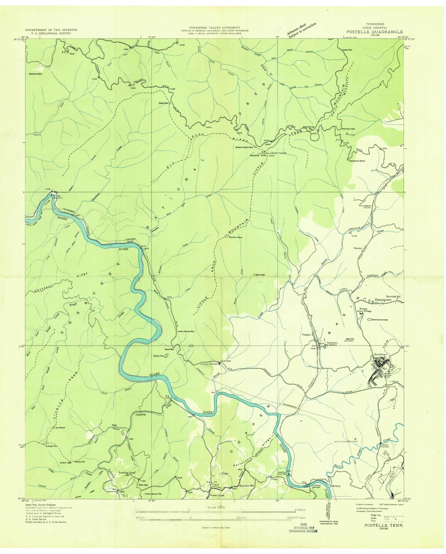
Classic USGS Ducktown Tennessee 7.5'x7.5' Topo Map
Couldn't load pickup availability
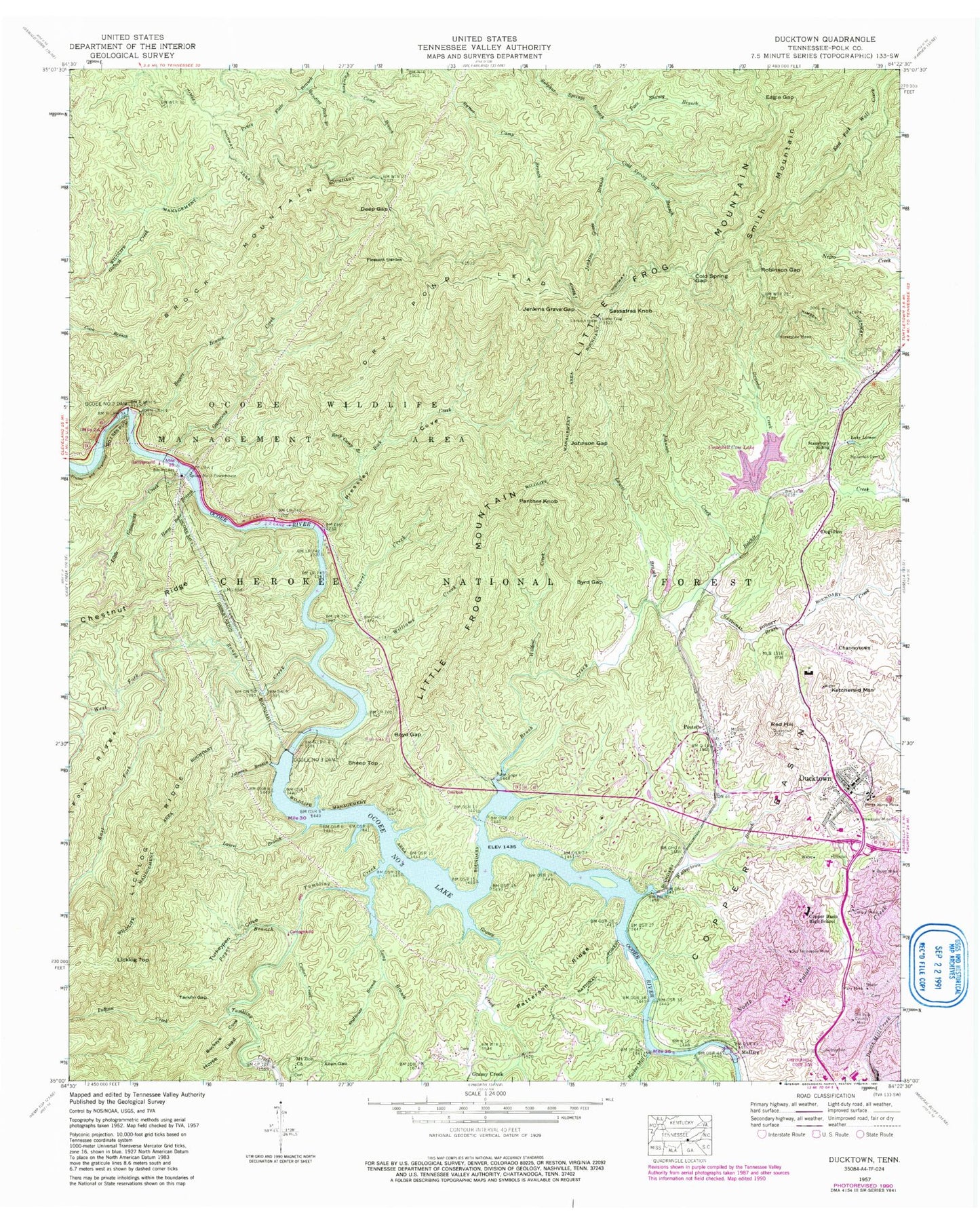
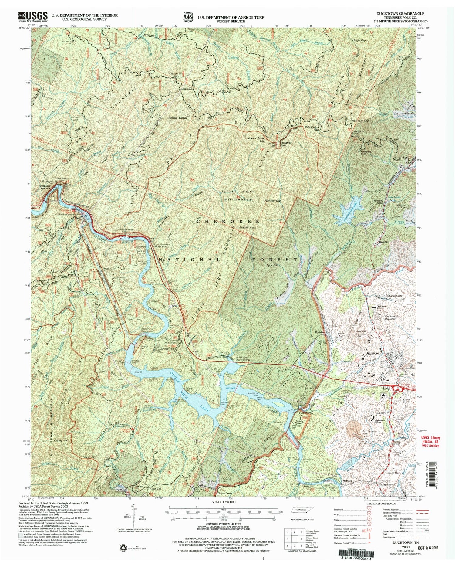
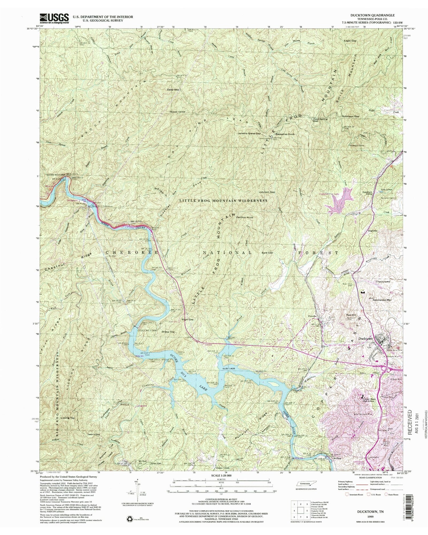
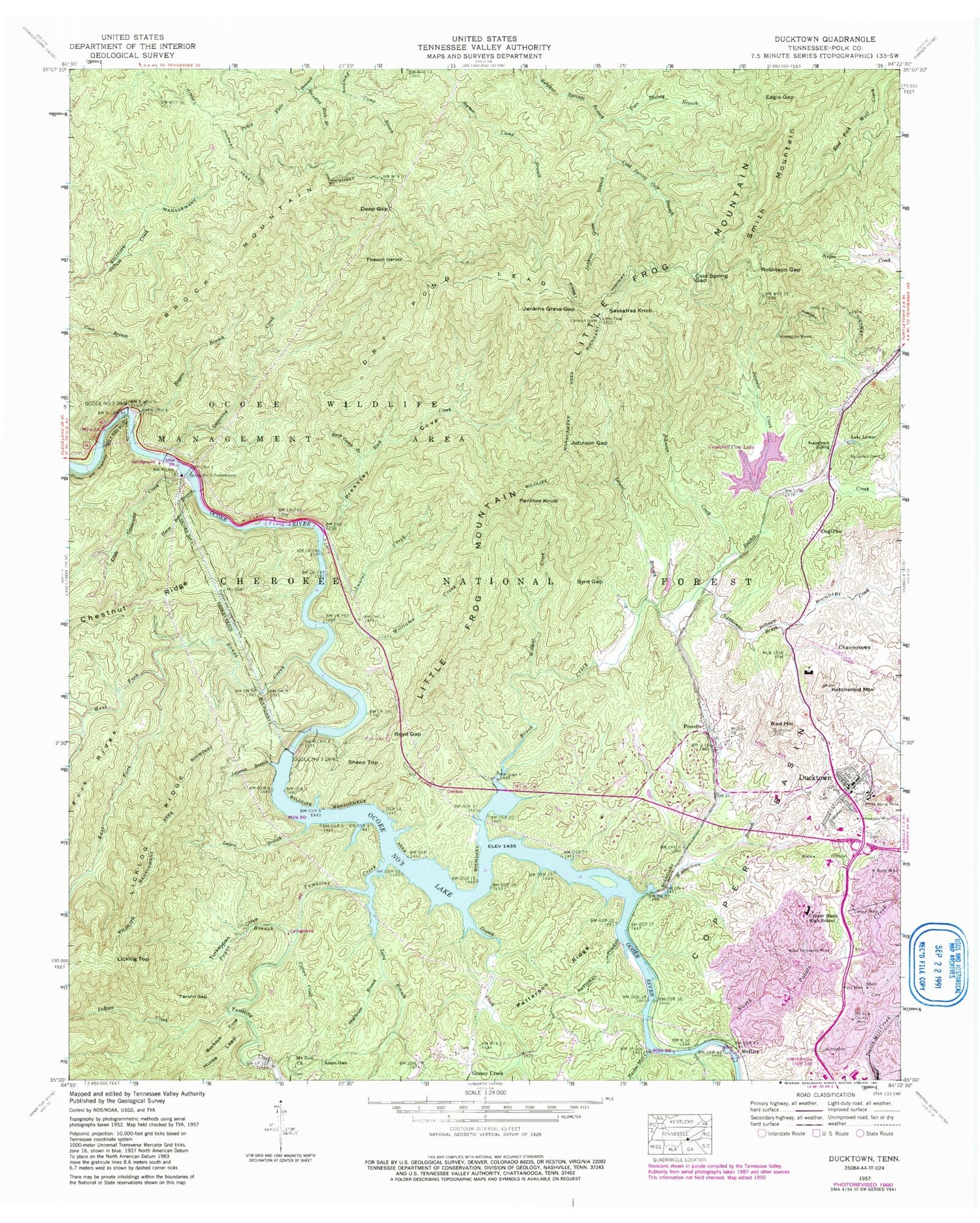
Historical USGS topographic quad map of Ducktown in the states of Tennessee, Georgia. Typical map scale is 1:24,000, but may vary for certain years, if available. Print size: 24" x 27"
This quadrangle is in the following counties: Polk.
The map contains contour lines, roads, rivers, towns, and lakes. Printed on high-quality waterproof paper with UV fade-resistant inks, and shipped rolled.
Contains the following named places: North Potato Creek, Sheep Top, Standing Rock Branch, Stansbury Siding, Stillhouse Branch, Tarkiln Gap, Turkeypen Cove, Walkertown Branch, Wildcat Creek, Allen Gap, Barker Mill Creek, Boyd Mine, Brock Mountain, Buckeye Cove, Burra-Burra Mine, Byrd Gap, Campbell Cove Lake, Carters Creek, Central Mine, Chestnut Ridge, Cold Spring Gap, Cold Spring Gap Branch, Copper Basin High School, Deep Gap, Dry Pond Lead, Ducktown, Ducktown High School, Eagle Gap, Gassaway Creek, Grassy Creek, Grassy Creek, Hiwassee Mine, Horse Bone Branch, Horseshoe Bend, Jenkins Grave Branch, Jenkins Grave Gap, Johnson Branch, Johnson Creek, Johnson Gap, Ketchersid Mountain, Lake Lamar, Laurel Branch, Laurel Branch, Licklog Top, Little Frog Mountain, Little Gassaway Creek, Long Branch, Mary Mine, McJunkin Cemetery, Mount Zion Church, Mount Zion Baptist Church, Ocoee Number Two Dam, Ocoee Number Three Dam, Ocoee Number Three Lake, Ocoee Number Three Powerhouse, Old Polk County Mine, Old Tennessee Mine, Pace Shanty Branch, Panther Knob, Patterson Ridge, Pleasant Garden, Postelle, Pressley Cove, Red Hill, Robinson Gap, Rock Camp Branch, Rock Creek, Rogers Branch, Rogers Bridge, Rough Creek, Sassafras Knob, F-Eleven Tailings Pond, F-Eleven Tailings Pond Dam, City Services Diversion Lake, City Services Diversion Dam, Ocoee Number Three Lake, Ocoee Number Three Dam, Tumbling Creek, Boyd Gap, Deweese Creek, Dogtown, Campbell Cove Dam, Ocoee Number Two Lake, Beckner Mill (historical), Copper Basin Medical Center, Jep Notch, Potato Hill, Tumbling Creek School (historical), Chanceytown, McHarg, Laurel Creek, Williams Creek, Payne Branch, Ducktown Elementary School, West Fork Rough Creek, Smith Mountain, Belcher Creek, Belltown Creek, Brush Creek, East Fork Rough Creek, Chestnut Branch, Little Frog Lookout, Little Frog Wilderness, Hedden Grave, Boyd Gap Observation Site, Bruch Creekshooting Range, Tennessee Valley Authority Boating Site, Licklog Trail, Beech Spring, Dry Pond Lead Trail, Rock Creek Trail, Rogers Branch Trail, Thunder Rock Recreation Area, Tumbling Creek Recreation Area, Ducktown Division (historical), Ducktown Post Office, Postelle Post Office, Little Frog Mountain Wilderness, City of Ducktown, Commissioner District 3, East Polk County Fire and Rescue Station 5, East Polk County Fire and Rescue Station 1, East Polk County Fire and Rescue Station 3, Polk County Sheriff's Department, Tumbling Creek, North Potato Creek, Sheep Top, Standing Rock Branch, Stansbury Siding, Stillhouse Branch, Tarkiln Gap, Turkeypen Cove, Walkertown Branch, Wildcat Creek, Allen Gap, Barker Mill Creek, Boyd Mine, Brock Mountain, Buckeye Cove, Burra-Burra Mine, Byrd Gap, Campbell Cove Lake, Carters Creek, Central Mine, Chestnut Ridge, Cold Spring Gap, Cold Spring Gap Branch, Copper Basin High School, Deep Gap, Dry Pond Lead, Ducktown, Ducktown High School, Eagle Gap, Gassaway Creek, Grassy Creek, Grassy Creek, Hiwassee Mine, Horse Bone Branch, Horseshoe Bend, Jenkins Grave Branch, Jenkins Grave Gap, Johnson Branch, Johnson Creek, Johnson Gap, Ketchersid Mountain, Lake Lamar, Laurel Branch, Laurel Branch, Licklog Top, Little Frog Mountain, Little Gassaway Creek, Long Branch, Mary Mine, McJunkin Cemetery, Mount Zion Church, Mount Zion Baptist Church, Ocoee Number Two Dam, Ocoee Number Three Dam, Ocoee Number Three Lake, Ocoee Number Three Powerhouse, Old Polk County Mine, Old Tennessee Mine, Pace Shanty Branch, Panther Knob, Patterson Ridge, Pleasant Garden, Postelle, Pressley Cove, Red Hill, Robinson Gap, Rock Camp Branch, Rock Creek, Rogers Branch, Rogers Bridge, Rough Creek, Sassafras Knob, F-Eleven Tailings Pond, F-Eleven Tailings Pond Dam, City Services Diversion Lake, City Services Diversion Dam, Ocoee Number Three Lake, Ocoee Number Three Dam, Tumbling Creek, Boyd Gap, Deweese Creek, Dogtown, Campbell Cove Dam, Ocoee Number Two Lake, Beckner Mill (historical), Copper Basin Medical Center, Jep Notch, Potato Hill, Tumbling Creek School (historical), Chanceytown, McHarg, Laurel Creek, Williams Creek, Payne Branch, Ducktown Elementary School, West Fork Rough Creek, Smith Mountain, Belcher Creek, Belltown Creek, Brush Creek, East Fork Rough Creek, Chestnut Branch, Little Frog Lookout, Little Frog Wilderness, Hedden Grave, Boyd Gap Observation Site, Bruch Creekshooting Range, Tennessee Valley Authority Boating Site, Licklog Trail, Beech Spring, Dry Pond Lead Trail, Rock Creek Trail