MyTopo
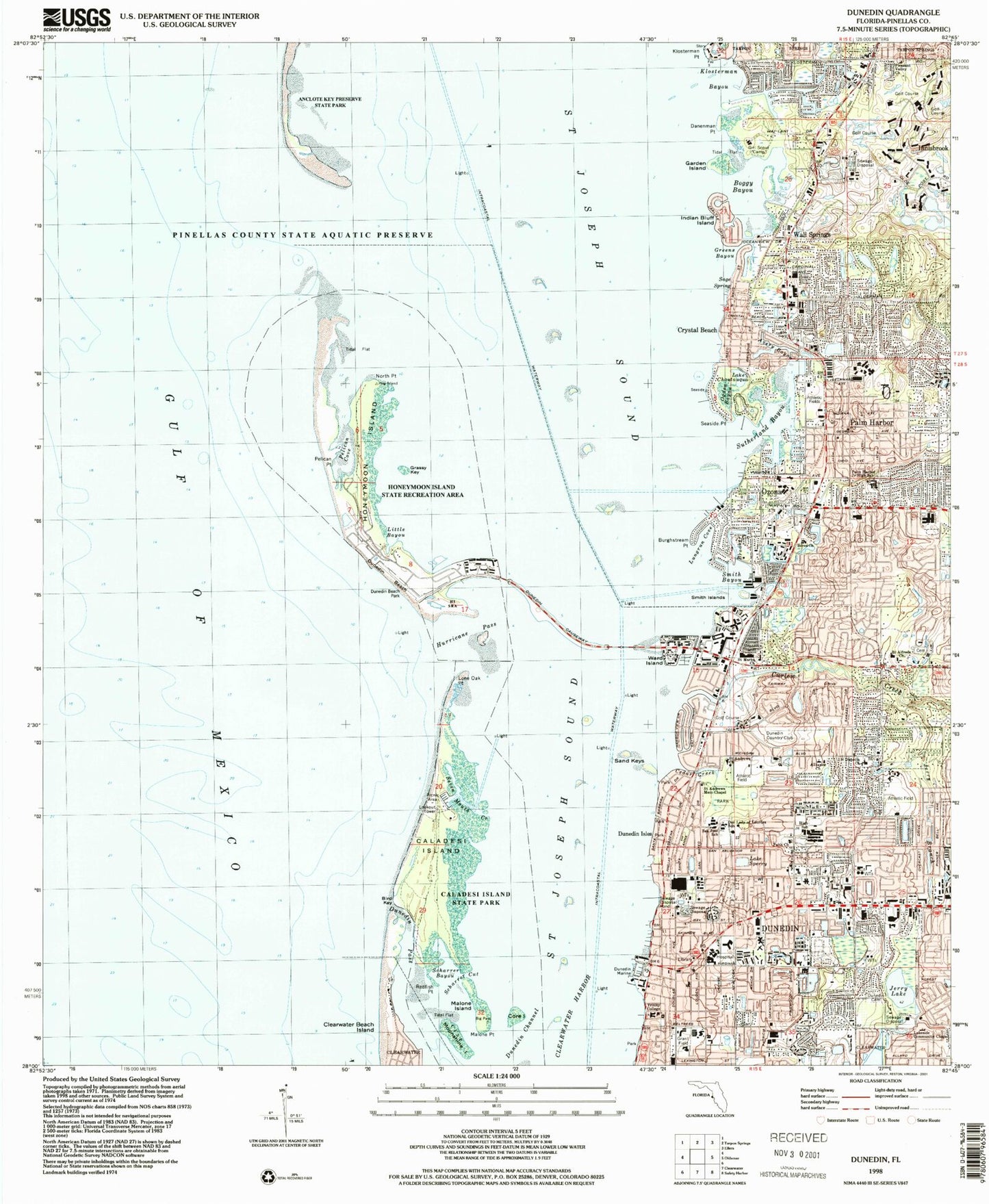
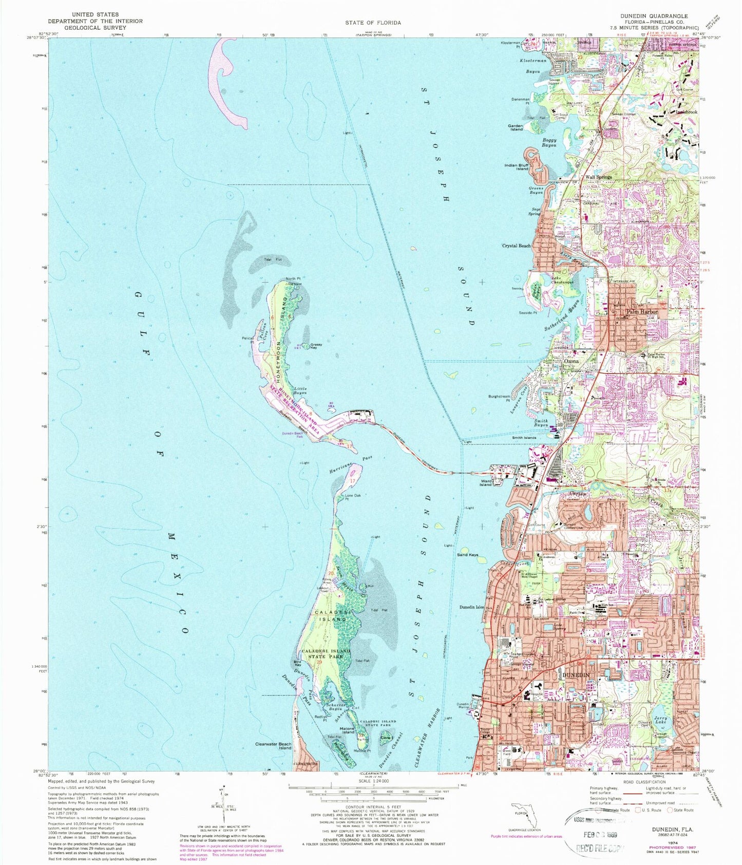
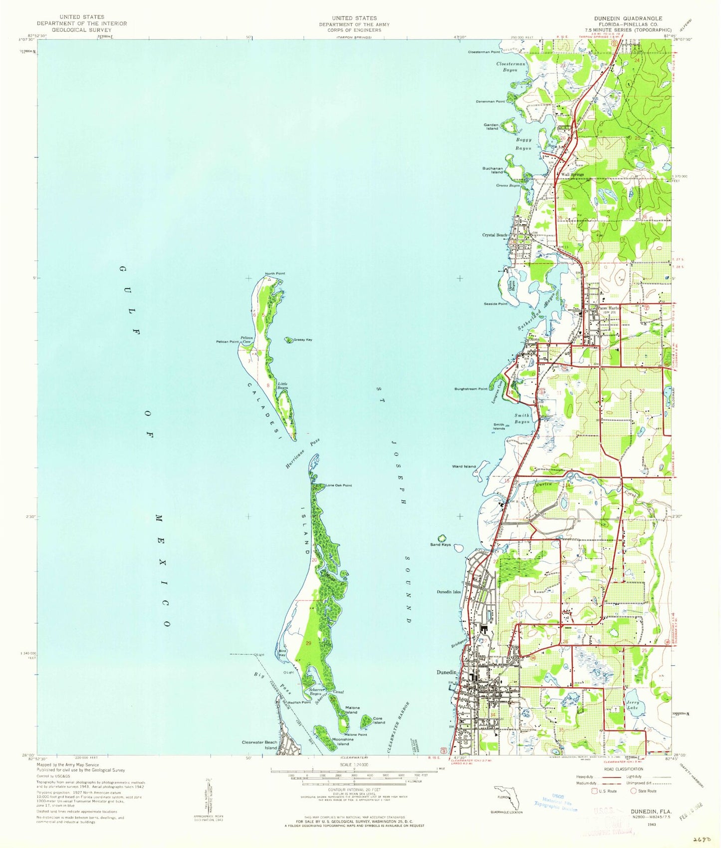
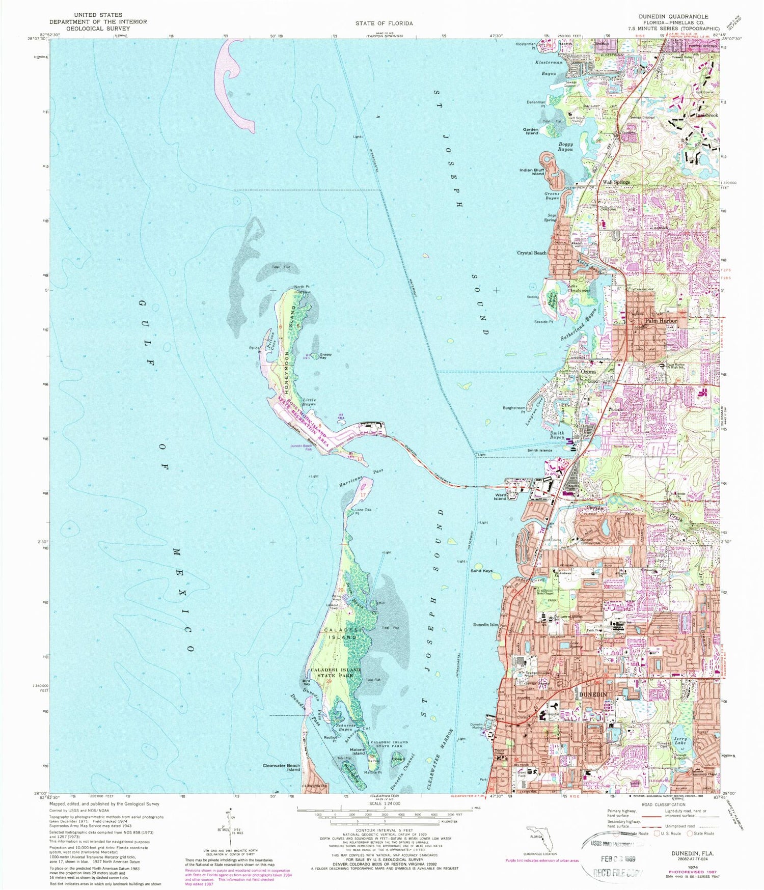
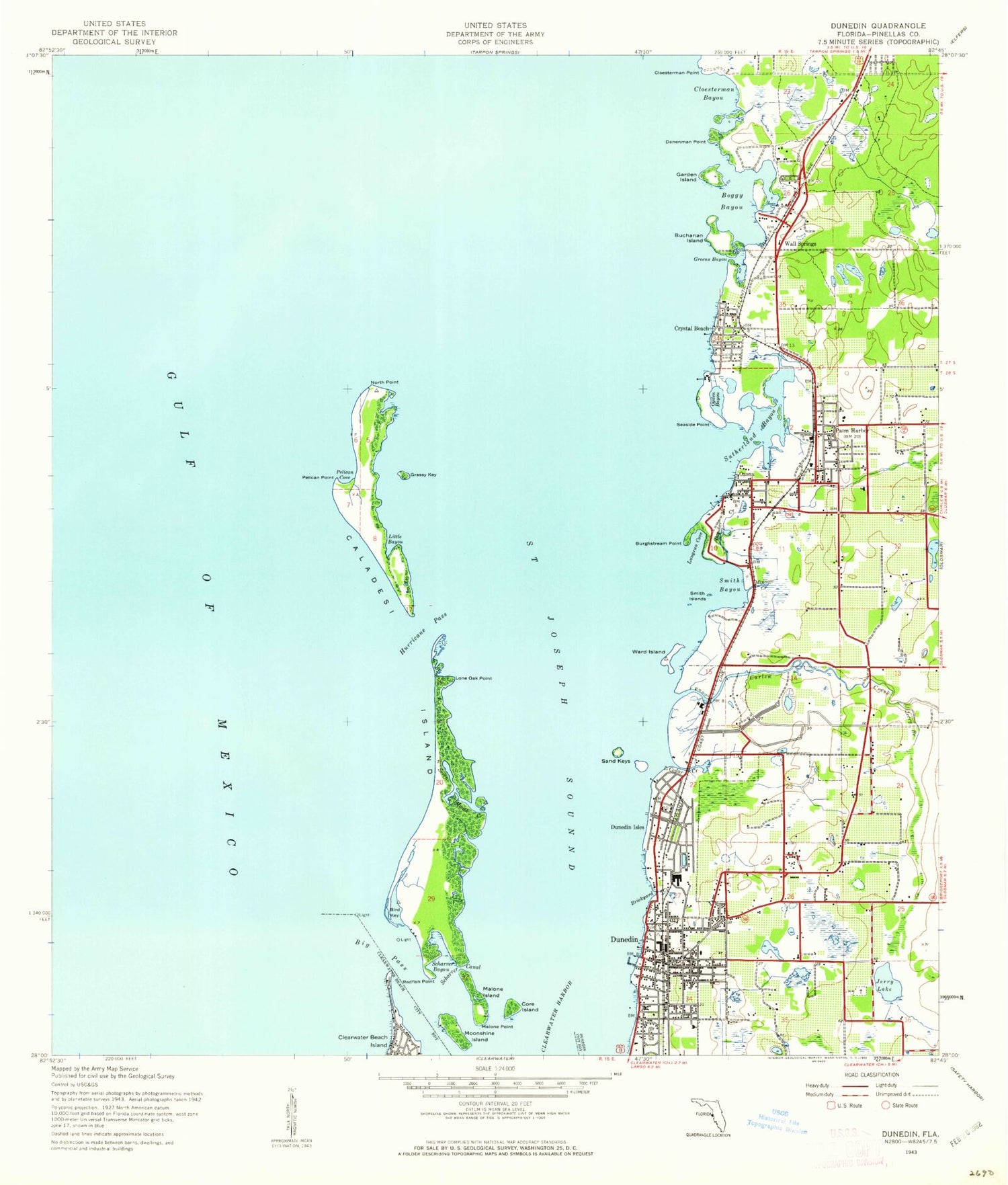
Classic USGS Dunedin Florida 7.5'x7.5' Topo Map
Couldn't load pickup availability
Historical USGS topographic quad map of Dunedin in the state of Florida. Typical map scale is 1:24,000, but may vary for certain years, if available. Print size: 24" x 27"
This quadrangle is in the following counties: Pinellas.
The map contains contour lines, roads, rivers, towns, and lakes. Printed on high-quality waterproof paper with UV fade-resistant inks, and shipped rolled.
Contains the following named places: Alliance Church, Avery Bayou, Bascule Bridge, Berea Church, Bird Key, Boggy Bayou, Brooker Creek, Burghstream Point, Caladesi Island, Caladesi Island State Park, Cedar Creek, Lake Chautauqua, Core Island, Curlew Creek, Danenman Point, Dunedin, Dunedin Beach, Dunedin Cemetery, Dunedin Channel, Dunedin Country Club, Dunedin Isles, Dunedin Marina, Dunedin Pass, Dunedin Highland Middle School, Faith Church, Garden Island, Florida Auto Exchange Stadium, Grassy Key, Greens Bayou, Honeymoon Island, Hurricane Pass, Indian Bluff Island, Jerry Branch, Jerry Lake, Klosterman Bayou, Klosterman Point, Lakeside Community Chapel, Little Bayou, Lone Oak Point, Lungrun Cove, Malone Island, Malone Point, Moonshine Island, North Dunedin Church, North Point Hog Island, Ogden Bayou, Our Lady of Lourdes Catholic School, Ozona, Palm Harbor, Palm Harbor Junior High School, Pelican Cove, Pelican Point, Pleasant Valley Church, Redfish Point, Sage Spring, Saint Alfreds Church, Saint Andrews Church, Saint Andrews Memorial Chapel, Saint Joseph Sound, Saint Marks Church, San Jose Elementary School, Sand Keys, Scharrer Bayou, Scharrer Cut, Seaside Point, Seven Mouth Creek, Smith Bayou, Smith Islands, Lake Sperry, Sutherland Bayou, Trinity College, Wall Springs, Ward Island, Three Rooker Bar, Crystal Beach, Acklocknayke (historical), Innisbrook, Scottish Village Shopping Center, Guy Plaza, Dunedin Shopping Center, Dunedin Plaza, Douglas Shopping Center, Community Plaza, Coastal Shopping Center, Causeway Plaza, Caladisa Shopping Center, Alderman Plaza, Point Plaza, Discovery Plaza, De Soto Junction Shopping Center, The Village at Saint George, The Shops of Palm Harbor, Seabreeze Shopping Center, Highland Lakes Shopping Center, The Fountains Shopping Center, East Lake Woodlands Plaza, Crystal Beach Plaza, Cove Springs, Harbor View, Mease Hospital and Clinic, Dunedin High School, Palm Harbor Middle School, Palm Harbor Elementary School, Ozona Elementary School, Curlew Hills Memory Gardens, Dunedin Highland Memorial Park, Parklawn Memory Gardens, Saint Mark Christian School, Palm Harbour Montessori School, Open Door School, Honeymoon Island State Park, Fort Harrison (historical), Dunedin Heliport, Mease Hospital Emergency Heliport, Tarpon Springs Division, Mease Dunedin Hospital, Dunedin Fire Rescue Station 60, Palm Harbor Fire Rescue Station 68, Pinellas County Sheriff's Office North District Station, Palm Harbor Census Designated Place, City of Dunedin, Christ Church, New Life Church, Unity Church of Palm Harbor, Dunedin-Mainland Sewage Treatment Facility, Dunedin Post Office, Curtis Fundamental Elementary School, Palm Harbor University High School, Wall Springs Park, Amberlea Park, Armston Park, Curlew Creek Park, Dunedin Youth Guild Park, Eagle Scout Park, Edgewater Park, Elizabeth Skinner-Jackson Playground, Hammock Park, Happy Tails Dog Park, Highlander Park, Louis A Vanech Recreation Complex, Scotsdale Park, Dunedin Stadium, Crystal Beach Park, Pop Stansell Park, Greenbriar Census Designated Place, Dunedin Fire Rescue Station 61, Palm Harbor Fire Rescue Station 66, Crystal Beach Post Office, Ozona Post Office, Palm Harbor Post Office, Alliance Church, Avery Bayou, Bascule Bridge, Berea Church, Bird Key, Boggy Bayou, Brooker Creek, Burghstream Point, Caladesi Island, Caladesi Island State Park, Cedar Creek, Lake Chautauqua, Core Island, Curlew Creek, Danenman Point, Dunedin, Dunedin Beach, Dunedin Cemetery, Dunedin Channel, Dunedin Country Club, Dunedin Isles, Dunedin Marina, Dunedin Pass, Dunedin Highland Middle School, Faith Church, Garden Island, Florida Auto Exchange Stadium, Grassy Key, Greens Bayou, Honeymoon Island, Hurricane Pass, Indian Bluff Island, Jerry Branch, Jerry Lake, Klosterman Bayou, Klosterman Point, Lakeside Community Chapel, Little Bayou, Lone Oak Point, Lungrun Cove, Malone Island, Malone Point, Moonshine Island, North Dunedin Church, North Point Hog Island, Ogden Bayou, Our Lady of Lourdes Catholic School, Ozona, Palm Harbor, Palm Harbor Junior High School, Pelican Cove, Pelican Point, Pleasant Valley Church, Redfish Point, Sage Spring, Saint Alfreds Church, Saint Andrews Church, Saint Andrews Memorial Chapel, Saint Joseph Sound, Saint Marks Church, San Jose Elementary School, Sand Keys, Scharrer Bayou, Scharrer Cut, Seaside Point, Seven Mouth Creek, Smith Bayou, Smith Islands, Lake Sperry, Sutherland Bayou, Trinity College, Wall Springs, Ward Island, Three Rooker Bar, Crystal Beach, Acklocknayke (historical), Innisbrook, Scottish Village Shopping Center, Guy Plaza, Dunedin Shopping Center, Dunedin Plaza, Douglas Shopping Center, Community Plaza, Coastal Shopping Center, Causeway Plaza, Caladisa Shopping Center