


MyTopo
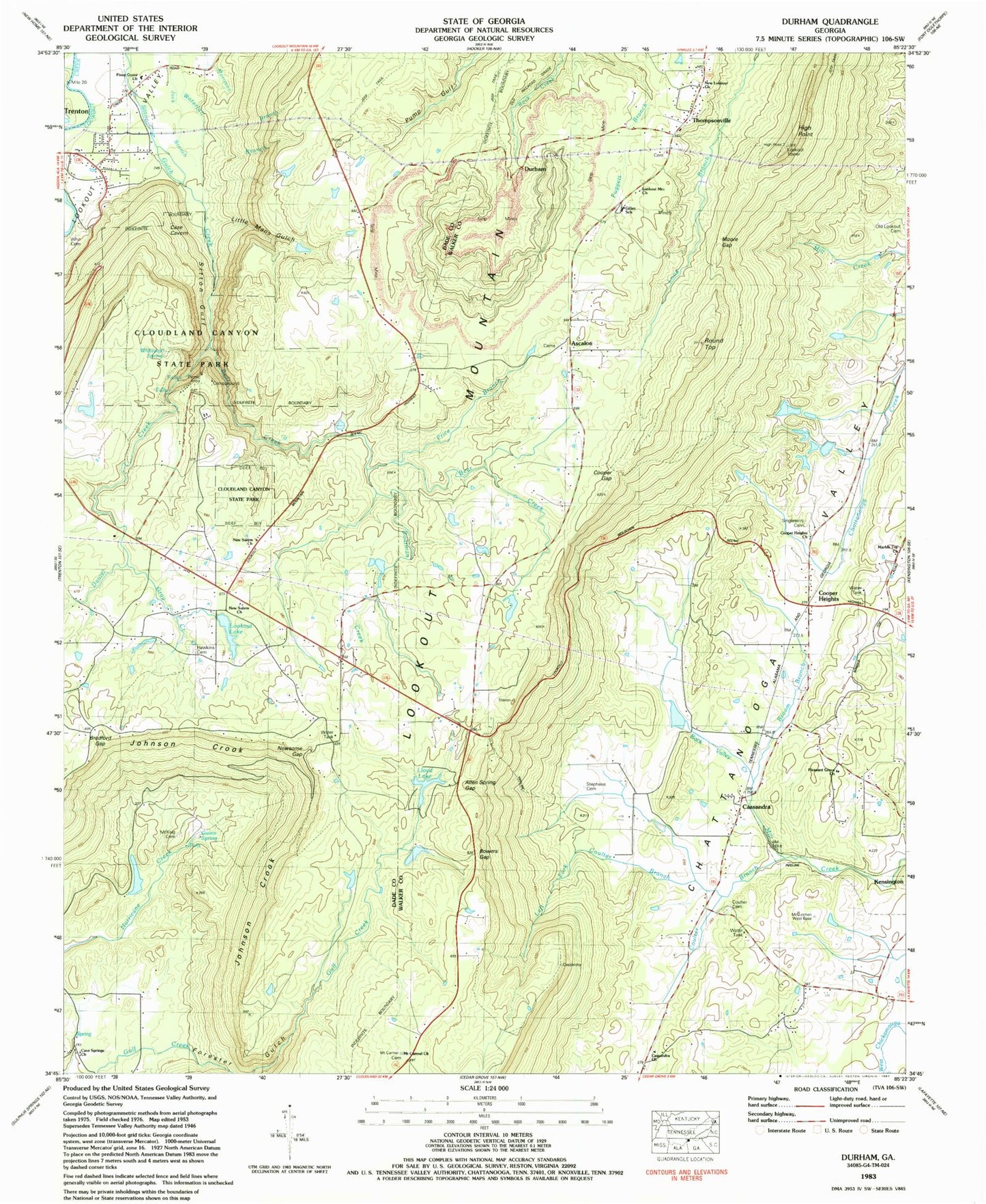
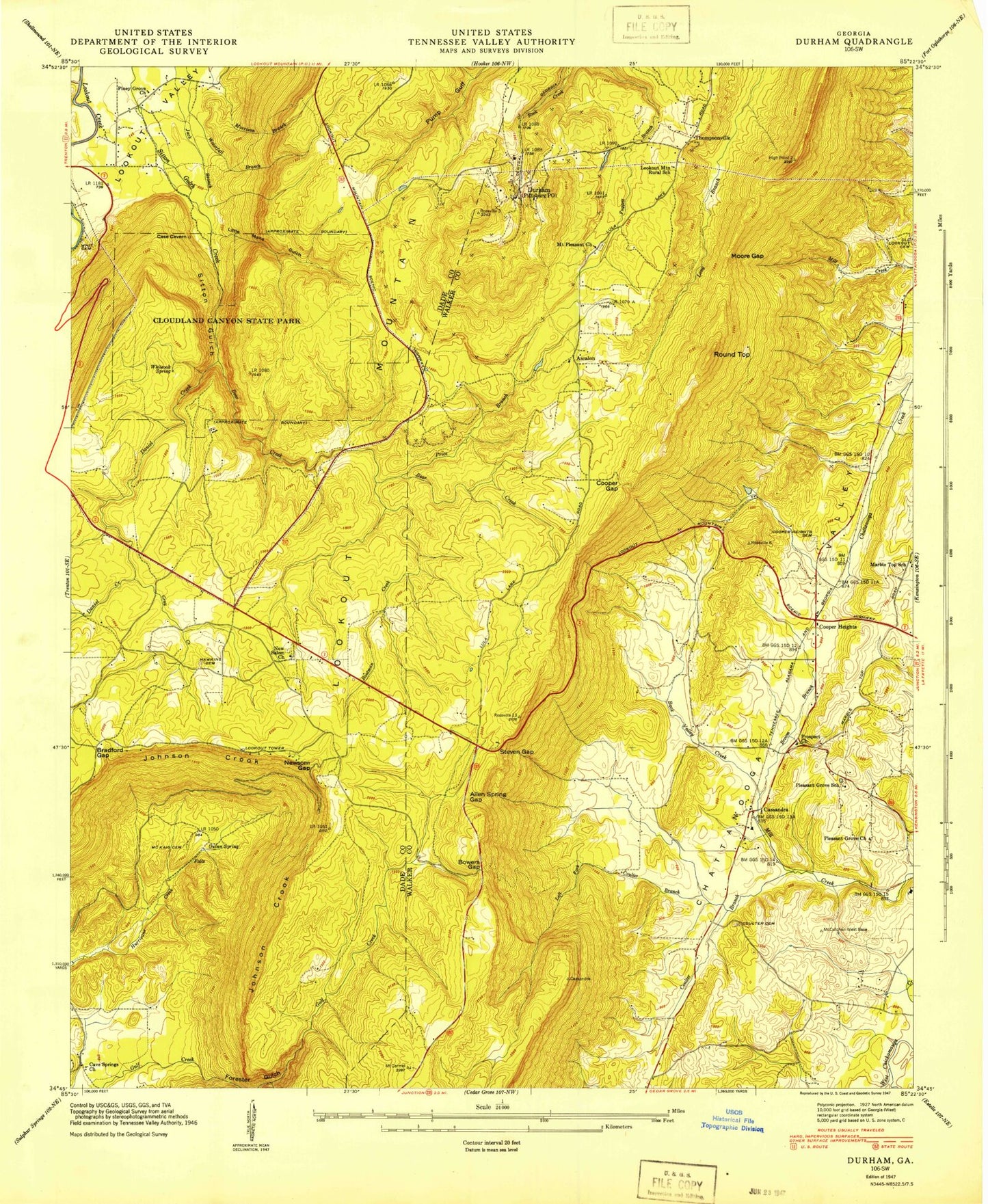
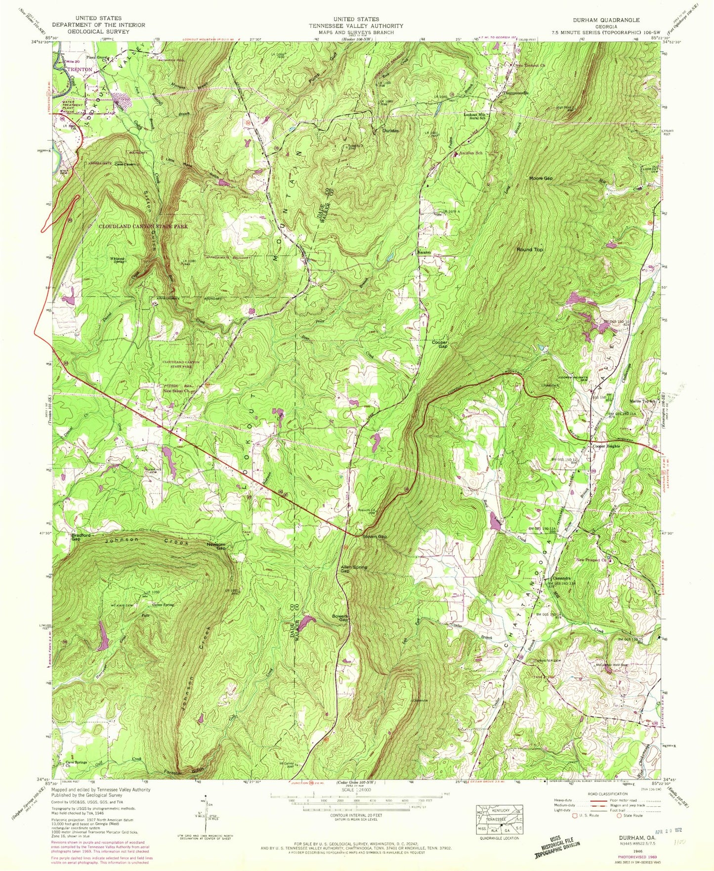
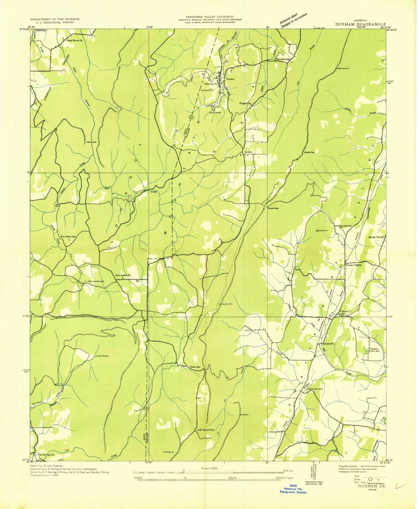
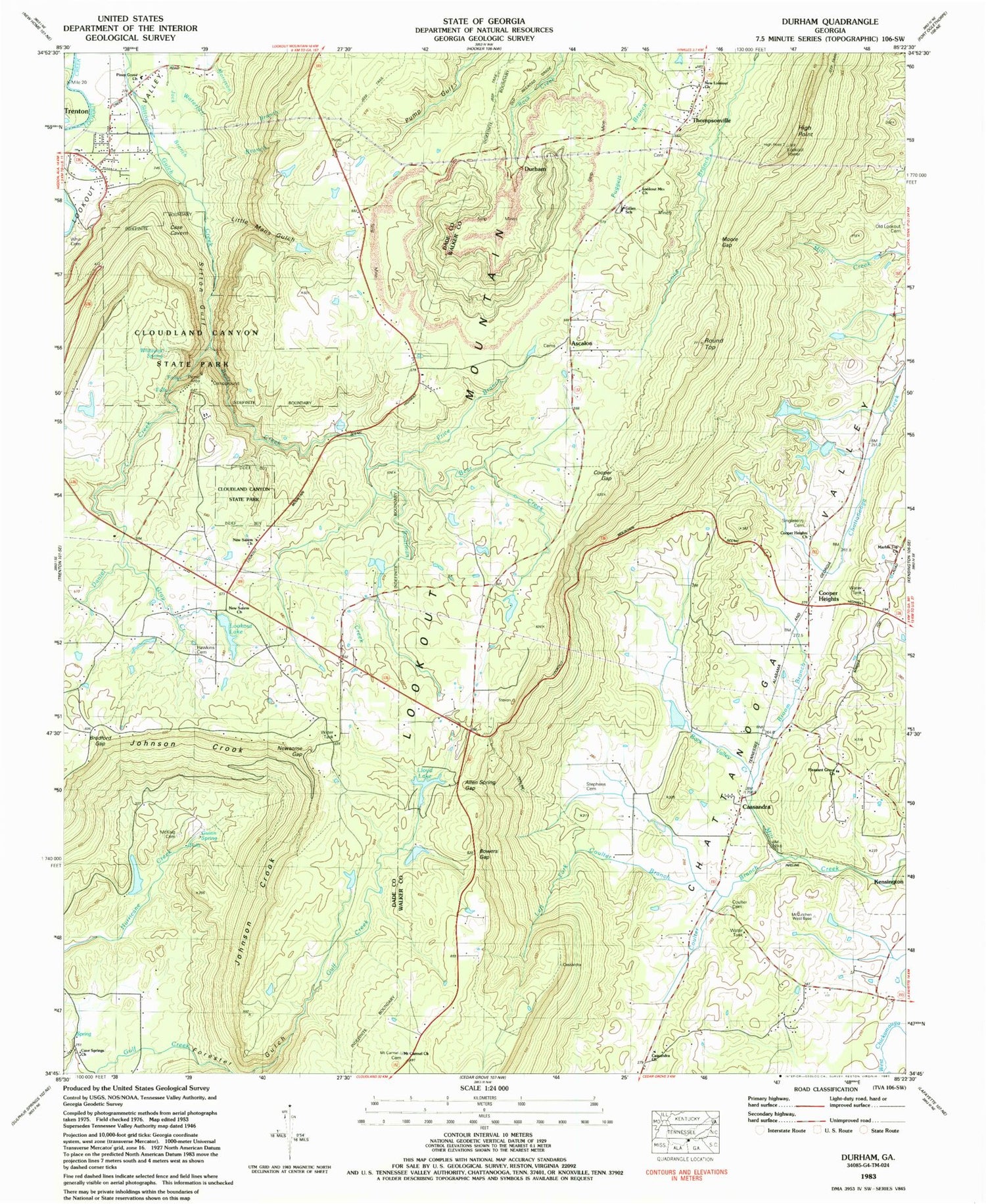
Classic USGS Durham Georgia 7.5'x7.5' Topo Map
Couldn't load pickup availability
Historical USGS topographic quad map of Durham in the state of Georgia. Typical map scale is 1:24,000, but may vary for certain years, if available. Print size: 24" x 27"
This quadrangle is in the following counties: Dade, Walker.
The map contains contour lines, roads, rivers, towns, and lakes. Printed on high-quality waterproof paper with UV fade-resistant inks, and shipped rolled.
Contains the following named places: Allen Spring Gap, Back Valley Creek, Bear Creek, Boatman Creek, Bradford Gap, Broom Branch, Cloudland Canyon State Park, Coulter Branch, Daniel Creek, Forester Gulch, Gunn Spring, Johnson Crook, Left Fork Coulter Branch, Little Mans Gulch, Lookout Mountain Rural School, Marble Top School, Moore Gap, New Lookout Church, Pleasant Grove Church, Piney Grove Baptist Church, Price Branch, Steven Gap, Town Creek, Whiteoak Spring, Durham, Round Top, Thompsonville, New Salem Church, New Salem School (historical), Yates Lake Dam, Yates Lake, Harris Lake Dam, Harris Lake, L Moore Dam, Lloyds Lake, Johnson Lake Dam, Johnson Lake, Lookout Lake Dam, Lookout Lake, Lloyds Lake Dam, Ott Lake Dam, Ott Lake, Miller Lake Dam, Miller Lake, Gross Lake Dam, Gross Lake, Plum Nelly, WADX-AM (Trenton), Ascalon Church, Ascalon, Ascalon School (historical), Barretts Church, Cassandra Baptist Church, Cassandra Church, Cooper Heights Church, Dillon (historical), Frick Gap (historical), Fuggett Church (historical), Henrys (historical), Marble Top Church, Mount Carmel Church, Mount Carmel School (historical), Pittsburg Post Office (historical), Pleasant Grove School (historical), Prospect School (historical), Stephens Cemetery, Gillen School, Bowers Gap, Cassandra, Cave Springs Church, Cooper Gap, Cooper Heights, Singleterry Cemetery, Coulter Cemetery, Gray Creek, Hawkins Cemetery, McKaig Cemetery, Newsome Gap, Sitton Gulf, Whit Cemetery, Trenton Division (historical), Trenton Division, Warren Field, New Salem Volunteer Fire Department, Allen Spring Gap, Back Valley Creek, Bear Creek, Boatman Creek, Bradford Gap, Broom Branch, Cloudland Canyon State Park, Coulter Branch, Daniel Creek, Forester Gulch, Gunn Spring, Johnson Crook, Left Fork Coulter Branch, Little Mans Gulch, Lookout Mountain Rural School, Marble Top School, Moore Gap, New Lookout Church, Pleasant Grove Church, Piney Grove Baptist Church, Price Branch, Steven Gap, Town Creek, Whiteoak Spring, Durham, Round Top, Thompsonville, New Salem Church, New Salem School (historical), Yates Lake Dam, Yates Lake, Harris Lake Dam, Harris Lake, L Moore Dam, Lloyds Lake, Johnson Lake Dam, Johnson Lake, Lookout Lake Dam, Lookout Lake, Lloyds Lake Dam, Ott Lake Dam, Ott Lake, Miller Lake Dam, Miller Lake, Gross Lake Dam, Gross Lake, Plum Nelly, WADX-AM (Trenton), Ascalon Church, Ascalon, Ascalon School (historical), Barretts Church, Cassandra Baptist Church, Cassandra Church, Cooper Heights Church, Dillon (historical), Frick Gap (historical), Fuggett Church (historical), Henrys (historical), Marble Top Church, Mount Carmel Church, Mount Carmel School (historical), Pittsburg Post Office (historical), Pleasant Grove School (historical), Prospect School (historical), Stephens Cemetery, Gillen School, Bowers Gap, Cassandra, Cave Springs Church, Cooper Gap, Cooper Heights, Singleterry Cemetery, Coulter Cemetery, Gray Creek, Hawkins Cemetery, McKaig Cemetery, Newsome Gap, Sitton Gulf, Whit Cemetery, Trenton Division (historical), Trenton Division, Warren Field, New Salem Volunteer Fire Department, Allen Spring Gap, Back Valley Creek, Bear Creek, Boatman Creek, Bradford Gap, Broom Branch, Cloudland Canyon State Park, Coulter Branch, Daniel Creek, Forester Gulch, Gunn Spring, Johnson Crook, Left Fork Coulter Branch, Little Mans Gulch, Lookout Mountain Rural School, Marble Top School, Moore Gap, New Lookout Church, Pleasant Grove Church, Piney Grove Baptist Church, Price Branch, Steven Gap, Town Creek, Whiteoak Spring, Durham, Round Top, Thompsonville, New Salem Church, New Salem School (historical), Yates Lake Dam, Yates Lake, Harris Lake Dam, Harris Lake, L Moore Dam, Lloyds Lake, Johnson Lake Dam, Johnson Lake, Lookout Lake Dam, Lookout Lake, Lloyds Lake Dam, Ott Lake Dam, Ott Lake, Miller Lake Dam, Miller Lake, Gross Lake Dam, Gross Lake, Plum Nelly, WADX-AM (Trenton), Ascalon Church, Ascalon, Ascalon School (historical), Barretts Church, Cassandra Baptist Church, Cassandra Church, Cooper Heights Church, Dillon (historical), Frick Gap (historical), Fuggett Church (historical), Henrys (historical), Marble Top Church, Mount Carmel Church, Mount Carmel School (historical), Pittsburg Post Office (historical), Pleasant Grove School (historical), Prospect School (historical), Stephens Cemetery, Gillen School, Bowers Gap