MyTopo
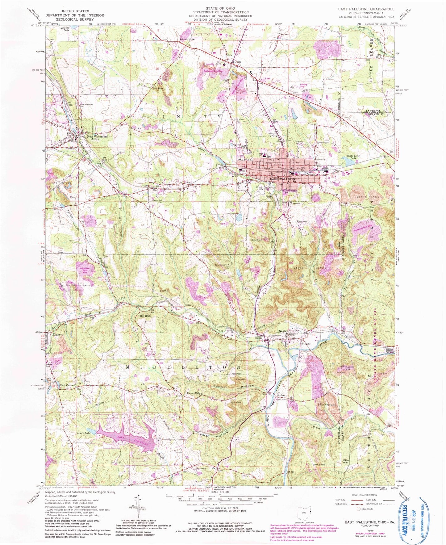
Classic USGS East Palestine Ohio 7.5'x7.5' Topo Map
Couldn't load pickup availability
Historical USGS topographic quad map of East Palestine in the states of Ohio, Pennsylvania. Map scale may vary for some years, but is generally around 1:24,000. Print size is approximately 24" x 27"
This quadrangle is in the following counties: Beaver, Columbiana, Lawrence.
The map contains contour lines, roads, rivers, towns, and lakes. Printed on high-quality waterproof paper with UV fade-resistant inks, and shipped rolled.
Contains the following named places: Achor, Achor Valley Cemetery, Aero Flight Center, Anchor Post Office, Bliss Hill, Booth Hill, Brick Church, Brush Run, Bull Creek, Caldwell Spring Lake, Caldwell Spring Lake Dam, Camp Hollow, Captain Taggart Elementary School, Centenary United Methodist Church, Clearwood Court, Crestview Elementary School, East Carmel, East Carmel Cemetery, East Carmel Post Office, East Fork Stateline Creek, East Palestine, East Palestine Church of the Nazarene, East Palestine City Park, East Palestine Fire Department, East Palestine Fire Department Station 1, East Palestine High School, East Palestine Memorial Public Library, East Palestine Police Department, East Palestine Post Office, First Church of Christ of East Palestine, First United Presbyterian Church of East Palestine, Fox Run Airport, Glenview Cemetery, Gould Pond, Gould Pond Dam, Grace Evangelical Lutheran Church, Jimtown, Lake Tomahawk, Lake Tomahawk Census Designated Place, Lake Tomahawk Dam, Leslie Run, Little Bull Creek, Mason Rich Cemetery, Middle Middle School, Mill Rock, Millrock Orchard, Millrock Post Office, Mount Zion Cemetery, Mount Zion United Methodist Church, Negley, Negley Census Designated Place, Negley Post Office, Negley Volunteer Fire Department and Emergency Medical Services, Negley Volunteer Fire Department Station 2, New Waterford, New Waterford Cemetery, New Waterford Police Department, New Waterford Post Office, New Waterford United Methodist Church, New Waterford United Presbyterian Church, New Waterford Volunteer Fire Department, North Avenue School, Our Lady of Lourdes Roman Catholic Church, Peace Valley Orchards, Pine Hill Jersey Farm, Pleasant Valley Mobile Home Park, Rogers Elementary School, Saint Marys Cemetery, Spruce Lake, State Line, State Line Lake, Stateline Creek, Sulphur Run, Swamp Hollow, Township of Middleton, Township of Unity, Turkey Run, Union Ridge, Unity, Unity Brick Church Cemetery, Unity Elementary School, Unity Post Office, Village of East Palestine, Village of New Waterford, West Fork Stateline Creek, Wheat Hill Estates, ZIP Codes: 44413, 44441, 44445, 44455