MyTopo
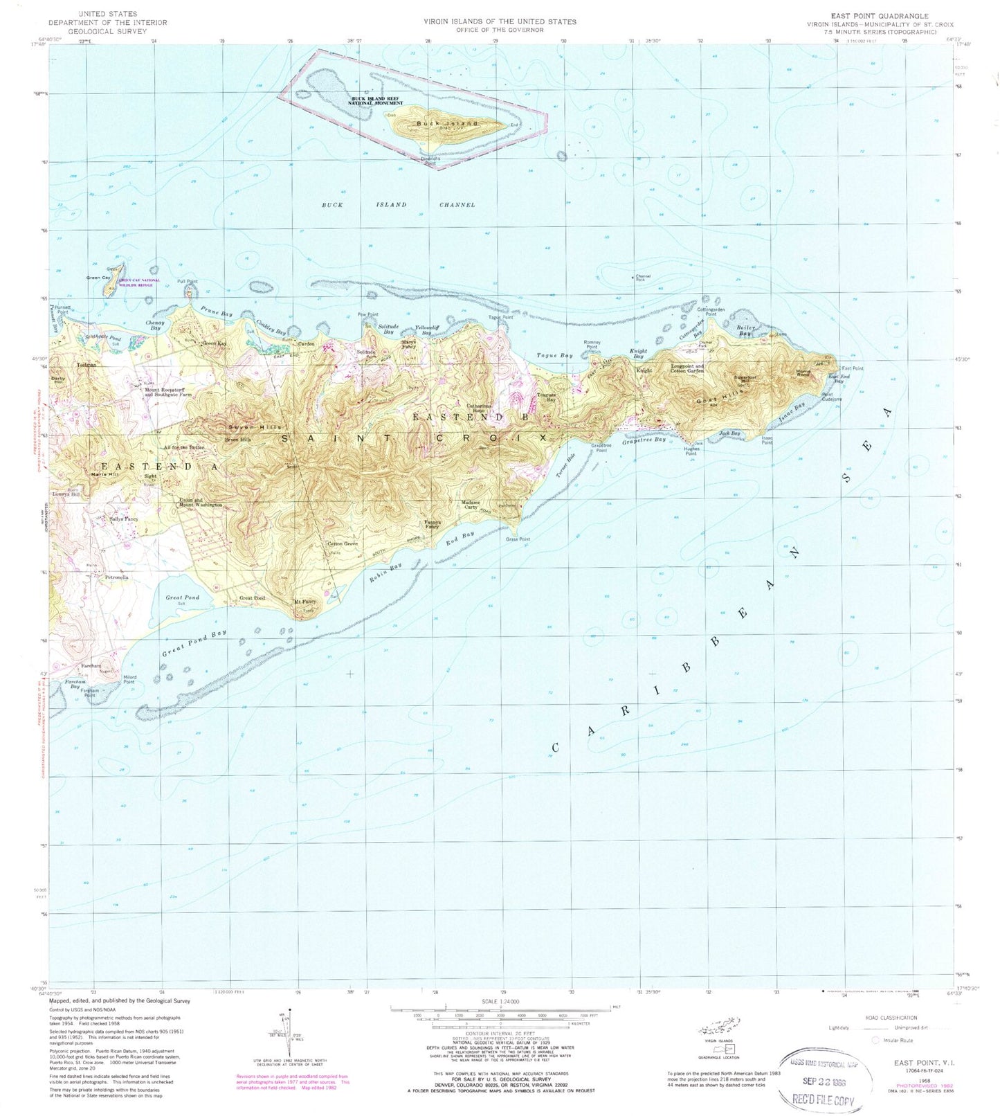
Classic USGS East Point Virgin Islands 7.5'x7.5' Topo Map
Couldn't load pickup availability
Historical USGS topographic quad map of East Point in the state of Virgin Islands. Map scale may vary for some years, but is generally around 1:24,000. Print size is approximately 24" x 27"
This quadrangle is in the following counties: St. Croix.
The map contains contour lines, roads, rivers, towns, and lakes. Printed on high-quality waterproof paper with UV fade-resistant inks, and shipped rolled.
Contains the following named places: Adjett, All for the Better, Bee Hill, Boiler Bay, Buccaneer Golf Course, Buck Island, Buck Island Channel, Buck Island Trail, Carden, Carden Bay, Carty Point, Catharinas Hope, Chenay Bay, Coakley Bay, Cotton Grove, Cotton Valley, Cottongarden Bay, Cottongarden Bay Beach, Cramer Park, Cramer Park Beach, Darby Hill, Diedrichs Point, Diedrichs Point Picnic Area, East End Bay, Easthill School, Estate A Piece of Land, Estate All for the Better, Estate Annas Hope, Estate Catherines Hope, Estate Coakley Bay, Estate Cotton Garden, Estate Cotton Grove, Estate Cotton Valley, Estate Fareham, Estate Great Pond, Estate Green Cay, Estate Gumbs Land, Estate Hartman, Estate Hope and Carton Hill, Estate Jacks Bay, Estate Kramers Park, Estate Little Profit, Estate Lowry Hill, Estate Madam Carty, Estate Marienhoj, Estate Mount Fancy, Estate Mount Retreat, Estate North Grapetree Bay, Estate North Slob, Estate Petronella, Estate Sallys Fancy, Estate Seven Hills, Estate Sight, Estate South Grapetree Bay, Estate South Slob, Estate Southgate, Estate Teague Bay, Estate Tipperary, Estate Turner Hole, Estate Union and Mount Washington, Estate Wood Cottage, Fairleigh Dickinson Territorial Park, Fannys Fancy, Fareham, Fareham Bay, Fareham Point, Goat Hills, Grapetree Bay, Grapetree Beach, Grapetree Point, Grass Point, Grassy Point Beach, Great Pond, Great Pond Bay, Green Cay, Green Cay Marina, Green Kay, Hughes Point, Isaac Bay, Isaac Point, Isaacs Bay Beach, Jack Bay, Knight, Knight Bay, Longpoint and Cotton Garden, Lowrys Hill, Madame Carty, Maria Hill, Marys Fancy, Milord Point, Morne Rond, Mount Fancy, Mount Fancy Hill, Mount Fancy Point, Mount Roepstorff and Southgate Farm, National Radio Astronomy Observatory, Parara Estate, Pentheny Hill, Petronella, Pinham Bay, Pinham Point, Point Cudejarre, Pole Hill, Pow Point, Powell Bay, Powell Point, Prune Bay, Prune Beach, Pull Point, Punnett Bay, Punnett Point, Reef Beach, Reef Golf Course, Robin Bay, Rod Bay, Romney Point, Saint Croix Yacht Club, Sallys Fancy, Seven Hills, Sight, Sight Mill, Sight Mound, Solitude, Solitude Bay, Southgate, Southgate Lagoon, Southgate Pond, Sugarloaf Hill, Tague Bay, Tague Point, Tamarind Reef Beach, Teagues Bay, Testman, Turner Hole, Union and Mount Washington, West Beach, West Beach Picnic Area, West Indies Laboratory Farleigh Dickinson University, Western Reef, Whale Point, Wismenog Point, Woodcottage Bay, Yellowcliff Bay