MyTopo
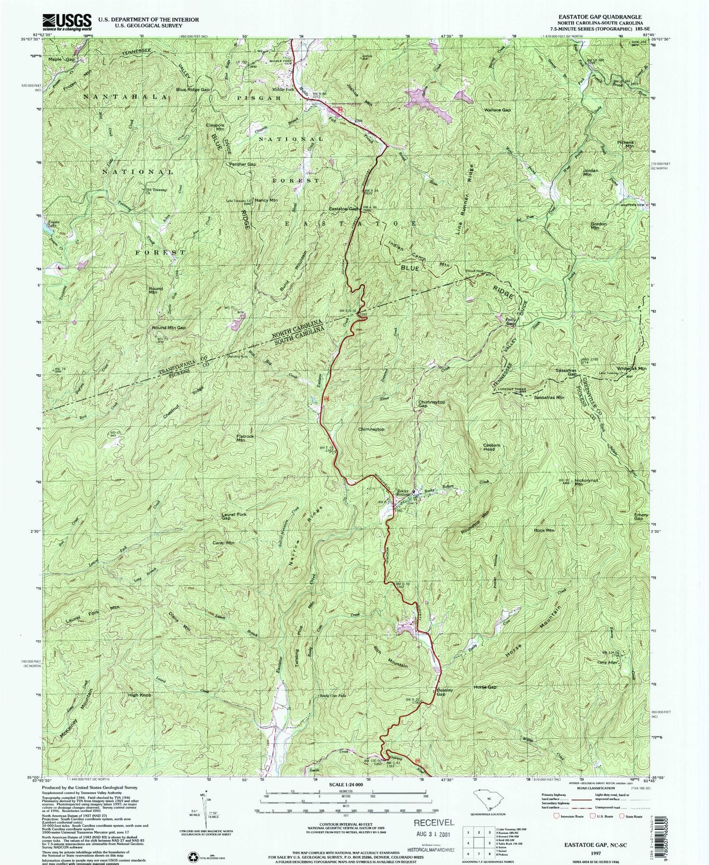
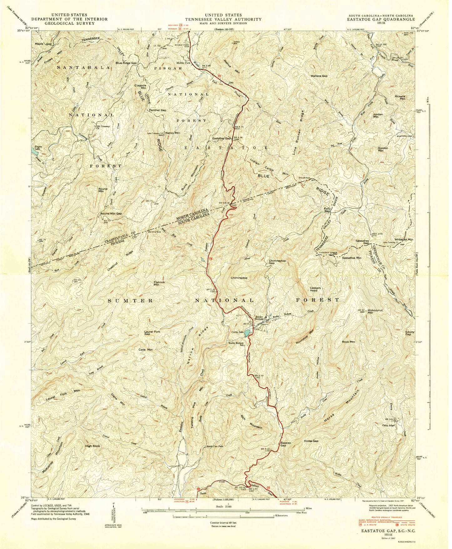
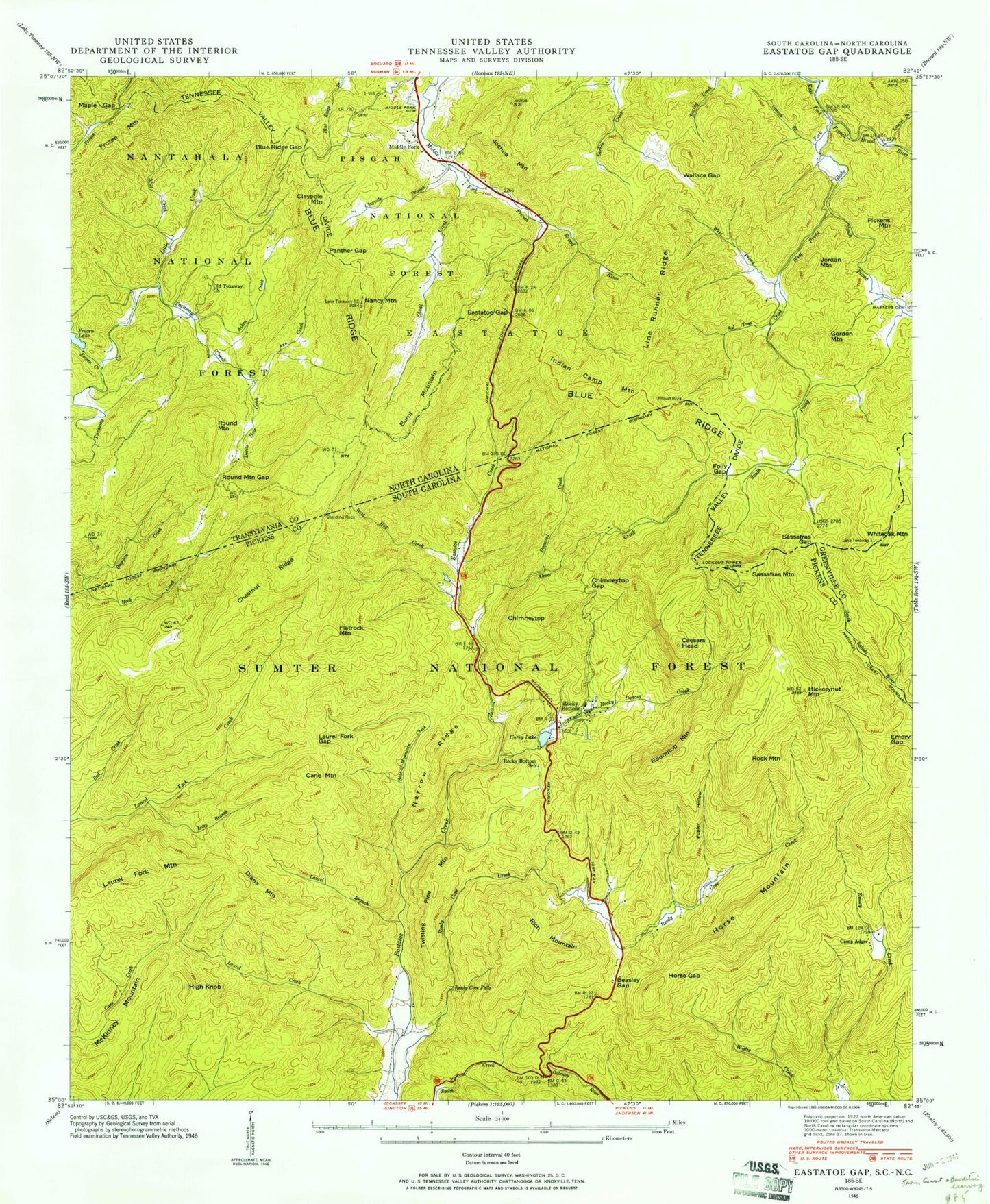
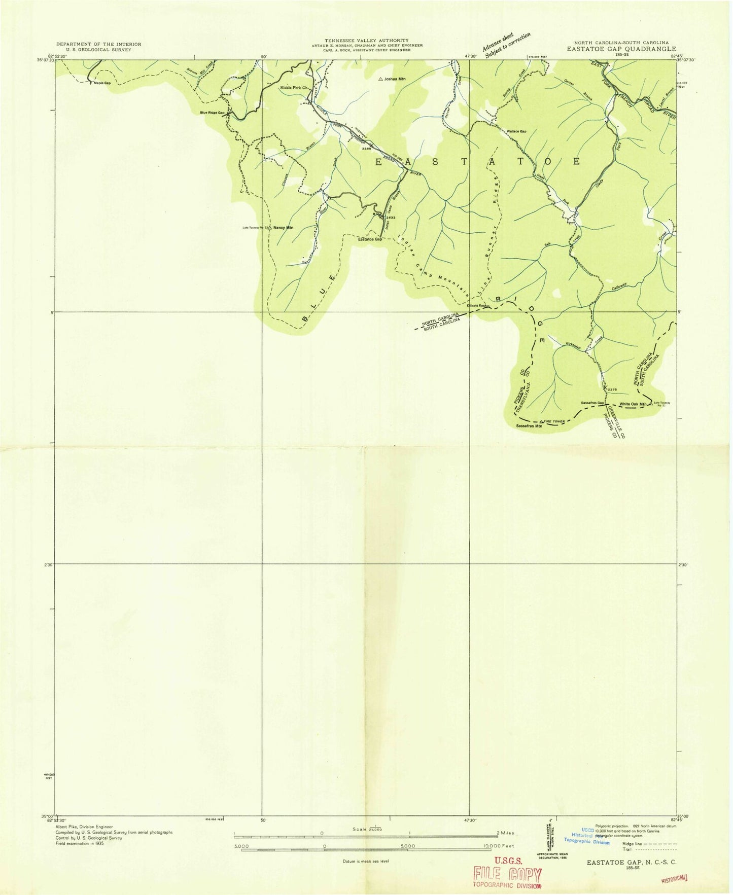
Classic USGS Eastatoe Gap North Carolina 7.5'x7.5' Topo Map
Couldn't load pickup availability
Historical USGS topographic quad map of Eastatoe Gap in the states of North Carolina, South Carolina. Typical map scale is 1:24,000, but may vary for certain years, if available. Print size: 24" x 27"
This quadrangle is in the following counties: Greenville, Pickens, Transylvania.
The map contains contour lines, roads, rivers, towns, and lakes. Printed on high-quality waterproof paper with UV fade-resistant inks, and shipped rolled.
Contains the following named places: Masters Cemetery, Laurel Branch, Ann Creek, Bearpen Creek, Blue Ridge Gap, Claypole Branch, Devils Hole Creek, Dogwood Creek, Eastatoe Gap, Folly Gap, Frozen Creek, Frozen Lake, Garren Branch, Glady Fork, Jane Cantrell Creek, Joshua Mountain, Line Runner Ridge, Little Creek, Maple Gap, Middle Fork Baptist Church Graveyard, Mill Creek, Nancy Mountain, Old Toxaway Church, Panther Gap, Round Mountain Gap, Sal Tom Creek, Sassafras Gap, Shoal Creek, South Prong Glady Fork, Wallace Gap, West Prong Glady Fork, Wild Hog Creek, Noname, The Wilds Dam, Frozen Lake Dam, Upper Sagar Dam, W S Sagar Lake, W S Sagar Lake Dam, Line Runner Ridge, Round Mountain, Ridge Haven, Burnt Mountain, Claypole Mountain, Frozen Mountain, Gordon Mountain, Indian Camp Mountain, Jordan Mountain, Middle Fork, Pickens Mountain, Round Mountain, Township of Eastatoe, Old Toxaway Baptist Church Upper Cemetery, Old Toxaway Baptist Church Lower Cemetery, Sassafras Mountain, Whiteoak Mountain, Abner Creek, Bad Creek, Beasley Gap, Camp Adger, Chestnut Ridge, Chimneytop Gap, Emory Gap, Hickorynut Mountain, Horse Gap, Laurel Branch, Laurel Fork Gap, Long Branch, Narrow Ridge, Poplar Hollow, Reedy Cove Creek, Reedy Cove Falls, Rocky Bottom, Rocky Bottom Creek, Side-of-Mountain Creek, Caesars Head, Cane Mountain, Chimneytop, Diana Mountain, Flatrock Mountain, High Knob, Horse Mountain, McKinney Mountain, Rich Mountain, Roundtop Mountain, Twisting Pine Mountain, Reedy Cove Creek Lake Dam D-1964, Reedy Cove Creek Lake, Alexanders Store (historical), Camp McCall, Camp Rocky Bottom, Rocky Bottom Baptist Church, Rocky Bottom Camp for the Blind, Rocky Bottom Baptist Church Graveyard, Rocky Bottom School (historical), Laurel Creek, Rock Mountain, North Pickens Division, Masters Cemetery, Laurel Branch, Ann Creek, Bearpen Creek, Blue Ridge Gap, Claypole Branch, Devils Hole Creek, Dogwood Creek, Eastatoe Gap, Folly Gap, Frozen Creek, Frozen Lake, Garren Branch, Glady Fork, Jane Cantrell Creek, Joshua Mountain, Line Runner Ridge, Little Creek, Maple Gap, Middle Fork Baptist Church Graveyard, Mill Creek, Nancy Mountain, Old Toxaway Church, Panther Gap, Round Mountain Gap, Sal Tom Creek, Sassafras Gap, Shoal Creek, South Prong Glady Fork, Wallace Gap, West Prong Glady Fork, Wild Hog Creek, Noname, The Wilds Dam, Frozen Lake Dam, Upper Sagar Dam, W S Sagar Lake, W S Sagar Lake Dam, Line Runner Ridge, Round Mountain, Ridge Haven, Burnt Mountain, Claypole Mountain, Frozen Mountain, Gordon Mountain, Indian Camp Mountain, Jordan Mountain, Middle Fork, Pickens Mountain, Round Mountain, Township of Eastatoe, Old Toxaway Baptist Church Upper Cemetery, Old Toxaway Baptist Church Lower Cemetery, Sassafras Mountain, Whiteoak Mountain, Abner Creek, Bad Creek, Beasley Gap, Camp Adger, Chestnut Ridge, Chimneytop Gap, Emory Gap, Hickorynut Mountain, Horse Gap, Laurel Branch, Laurel Fork Gap, Long Branch, Narrow Ridge, Poplar Hollow, Reedy Cove Creek, Reedy Cove Falls, Rocky Bottom, Rocky Bottom Creek, Side-of-Mountain Creek, Caesars Head, Cane Mountain, Chimneytop, Diana Mountain, Flatrock Mountain, High Knob, Horse Mountain, McKinney Mountain, Rich Mountain, Roundtop Mountain, Twisting Pine Mountain, Reedy Cove Creek Lake Dam D-1964, Reedy Cove Creek Lake, Alexanders Store (historical), Camp McCall, Camp Rocky Bottom, Rocky Bottom Baptist Church, Rocky Bottom Camp for the Blind, Rocky Bottom Baptist Church Graveyard, Rocky Bottom School (historical), Laurel Creek, Rock Mountain, North Pickens Division, Masters Cemetery, Laurel Branch, Ann Creek, Bearpen Creek, Blue Ridge Gap, Claypole Branch, Devils Hole Creek, Dogwood Creek, Eastatoe Gap, Folly Gap, Frozen Creek, Frozen Lake, Garren Branch, Glady Fork, Jane Cantrell Creek, Joshua Mountain, Line Runner Ridge, Little Creek, Maple Gap, Middle Fork Baptist Church Graveyard, Mill Creek, Nancy Mountain, Old Toxaway Church, Panther Gap, Round Mountain Gap, Sal Tom Creek, Sassafras Gap, Shoal Creek, South Prong Glady Fork, Wallace Gap, West Prong Glady Fork, Wild Hog Creek, Noname, The Wilds Dam, Frozen Lake Dam, Upper Sagar Dam, W S Sagar Lake, W S Sagar Lake Dam, Line Runner Ridge, Round Mountain, Ridge Haven, Burnt Mountain