MyTopo
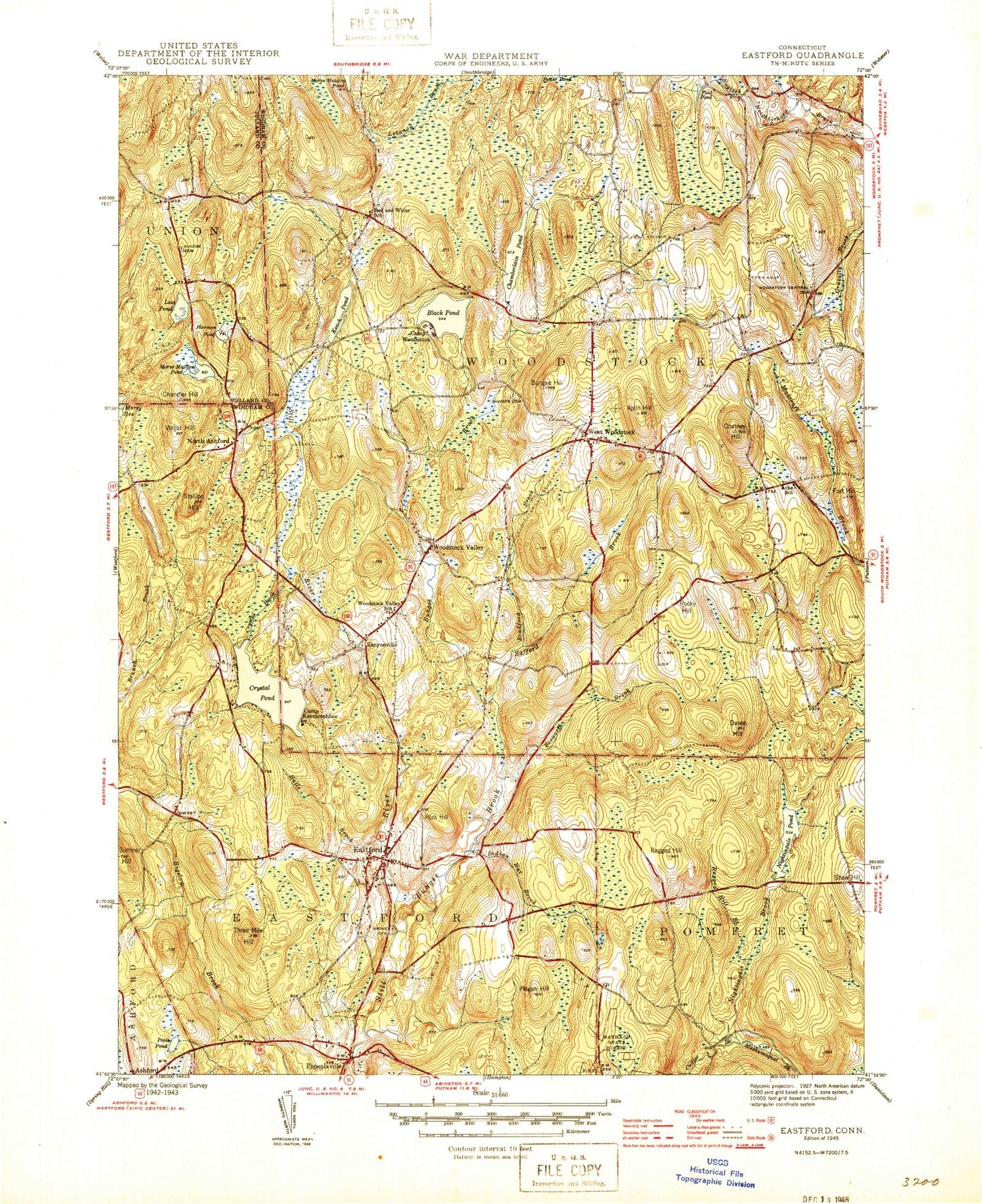
Classic USGS Eastford Connecticut 7.5'x7.5' Topo Map
Couldn't load pickup availability
Historical USGS topographic quad map of Eastford in the state of Connecticut. Map scale may vary for some years, but is generally around 1:24,000. Print size is approximately 24" x 27"
This quadrangle is in the following counties: Tolland, Windham.
The map contains contour lines, roads, rivers, towns, and lakes. Printed on high-quality waterproof paper with UV fade-resistant inks, and shipped rolled.
Contains the following named places: Abbott Dam, Abbott Pond, Allen Hill, Angel Brook, Aplin Hill, Barlow Cemetery, Black Hall River, Black Pond, Black Pond Brook, Black Pond Campground, Bosworth Brook, Bradford Brook, Bradford Hill, Branch Brook, Buell Brook, Buells Greenhouses, Bungay Cemetery, Bungay Fire Department Station 77, Bungee Brook, Bungee Hill, Camp Eastford, Camp Keemosahbee, Camp Woodstock, Captain Shepard Hill, Cedar Swamp, Cedar Swamp Brook, Cedar Swamp Pond, Cemetery Brook, Central Cemetery, Chamberlain Hill, Chamberlain Lake Campground, Chamberlain Pond, Chamberlain Pond Dam, Chandler Hill, Chestnut Hill, Church of the Good Shepherd, Coatney Hill, Coburn Hill, Corbin Hill, Corbin Wildlife Marsh Dam, Crams Brook, Crawford Hill, Crystal Pond, Crystal Pond Brook, Crystal Pond Dam, Daven Hill, Davis Hill, Deacon Tim Perrin Hill, Dean Hill, Dickinson Pond, East Hill, Eastford, Eastford Airport, Eastford Congregational Church, Eastford Elementary School, Eastford Fire Department Station 71, Eastford Post Office, Eastford Public Library, Evergreen Park, Fort Hill, Furnace Hill, Great Cedar Swamp, Griggs Pond Dam, Grove Cemetery, Halls Brook, Hammond Hill, Harakleys Pond, Harmon Pond, Harrington Hill, Havens Ledge Brook, Hiscox Hill, Hiscox Pond, Hole in the Wall Gang Paul Newman Camp, Howard Hill, Indian Hut Brook, Joe Margy Hill, Keach Pond, Kenyon Hill, Kenyon Pond, Kenyon Pond Dam, Kenyonville, Lake Bungee, Lake Bungee Census Designated Place, Lincoln Hill, Lost Pond, Lost Pond Brook, Lyon Brook, Marcy Cemetery, Martin Hill, Mason Hill, Morse Hill, Morse Meadow Pond, Morse Pond, Morse Reservoir, Neber Pond, Nightingale Brook, Nightingale Pond, Nightingale Pond Dam, North Ashford, North Ashford Brook, North Ashford Cemetery, Norton Brook, Old Cemetery, Phoenixville, Phoenixville Park Ponds, Pisgah Hill, Poole Pond, Poole Pond Dam, Pork Hill, Pout Pond, Ragged Hill, Ragged Hill Brook, Red and White School, Redhead Meadows Brook, Rindge Cemetery, Rocky Hill, Safford Brook, Shaw Hill, Sherman Hill, Sibley Brook, Sibley Cemetery, Skinner Brook, Spalding Cemetery, Stallion Hill, Summer Hill, Taft Pond, Tatem Company Ponds, Threemile Hill, Thunder Hill, Toutant Airport, Town of Eastford, Town of Woodstock, Trowbridge Cemetery, Underwood Hill, Upper Bungee Lake, Upper Bungee Lake Dam, Vinton Hill, Walker Brook, Warren Brook, West Woodstock, West Woodstock Library, Wheaton Hill, Witches Woods, Witches Woods Census Designated Place, Witches Woods Lake, Woodstock Camp, Woodstock Town Highway Garage, Woodstock Valley, ZIP Codes: 06242, 06281, 06282