MyTopo
Classic USGS Edinburg New York 7.5'x7.5' Topo Map
Couldn't load pickup availability
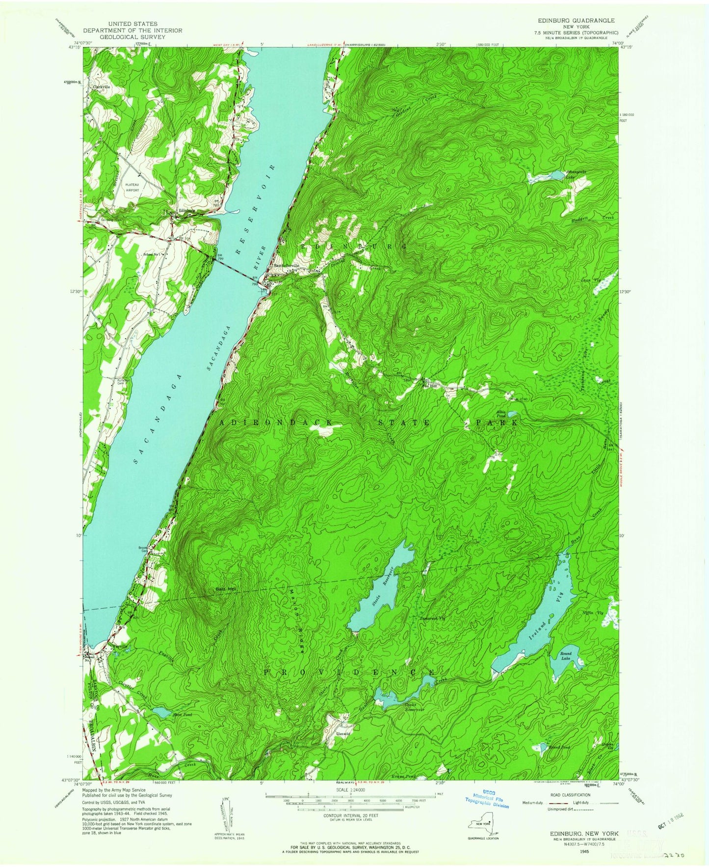
Historical USGS topographic quad map of Edinburg in the state of New York. Typical map scale is 1:24,000, but may vary for certain years, if available. Print size: 24" x 27"
This quadrangle is in the following counties: Fulton, Saratoga.
The map contains contour lines, roads, rivers, towns, and lakes. Printed on high-quality waterproof paper with UV fade-resistant inks, and shipped rolled.
Contains the following named places: Adirondack Bible College, Albia Pond, Bald Bluff, Batcheller Creek, Batchellerville, Anderson Cemetery, Cloutler Creek, Consolidated School Number 1 (historical), Cooks Reservoir, Deming Creek, Edinburg, Fayville, Fayville Creek, Fox Hill, Gordons Creek, Ireland Vly, Johnnycake Lake, Little Hans Creek, Loon Vly, Maxon Ridge, Partridge Cemetery, Ronna Pond, Round Lake, Shew Pond, Steele Creek, Steele Reservoir, Tamarack Vly, Thousand Acre Swamp, Blodgett Vly, West Vly Creek, Clarkville, Glenwild, Beecher Creek, Circle K Ranch Airport, The Farm Airport (historical), Plateau Sky Ranch Airport, Town of Edinburg, Copeland Covered Bridge, School Number 1 (historical), Sacandaga Reservoir Bridge, Batchellerville Presbyterian Church, Edinburg Bible Chapel, Edinburg United Methodist Church, Edinburg Town Hall, Edinburg Emergency Squad, Edinburg Volunteer Fire Company, Edinburg Volunteer Emergency Squad, Lewis Field, Adirondack Bible College, Albia Pond, Bald Bluff, Batcheller Creek, Batchellerville, Anderson Cemetery, Cloutler Creek, Consolidated School Number 1 (historical), Cooks Reservoir, Deming Creek, Edinburg, Fayville, Fayville Creek, Fox Hill, Gordons Creek, Ireland Vly, Johnnycake Lake, Little Hans Creek, Loon Vly, Maxon Ridge, Partridge Cemetery, Ronna Pond, Round Lake, Shew Pond, Steele Creek, Steele Reservoir, Tamarack Vly, Thousand Acre Swamp, Blodgett Vly, West Vly Creek, Clarkville, Glenwild, Beecher Creek, Circle K Ranch Airport, The Farm Airport (historical), Plateau Sky Ranch Airport, Town of Edinburg, Copeland Covered Bridge, School Number 1 (historical), Sacandaga Reservoir Bridge, Batchellerville Presbyterian Church, Edinburg Bible Chapel, Edinburg United Methodist Church, Edinburg Town Hall, Edinburg Emergency Squad, Edinburg Volunteer Fire Company, Edinburg Volunteer Emergency Squad, Lewis Field, Adirondack Bible College, Albia Pond, Bald Bluff, Batcheller Creek, Batchellerville, Anderson Cemetery, Cloutler Creek, Consolidated School Number 1 (historical), Cooks Reservoir, Deming Creek, Edinburg, Fayville, Fayville Creek, Fox Hill, Gordons Creek, Ireland Vly, Johnnycake Lake, Little Hans Creek, Loon Vly, Maxon Ridge, Partridge Cemetery, Ronna Pond, Round Lake, Shew Pond, Steele Creek, Steele Reservoir, Tamarack Vly, Thousand Acre Swamp, Blodgett Vly, West Vly Creek, Clarkville, Glenwild, Beecher Creek, Circle K Ranch Airport, The Farm Airport (historical), Plateau Sky Ranch Airport, Town of Edinburg, Copeland Covered Bridge, School Number 1 (historical), Sacandaga Reservoir Bridge, Batchellerville Presbyterian Church, Edinburg Bible Chapel, Edinburg United Methodist Church, Edinburg Town Hall, Edinburg Emergency Squad, Edinburg Volunteer Fire Company, Edinburg Volunteer Emergency Squad, Lewis Field