MyTopo
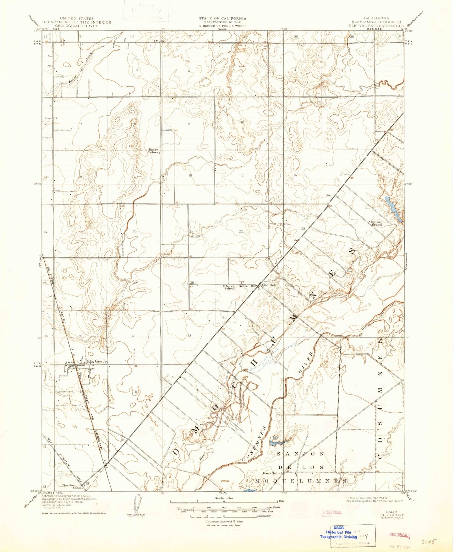
Classic USGS Elk Grove California 7.5'x7.5' Topo Map
Couldn't load pickup availability
Historical USGS topographic quad map of Elk Grove in the state of California. Map scale may vary for some years, but is generally around 1:24,000. Print size is approximately 24" x 27"
This quadrangle is in the following counties: Sacramento.
The map contains contour lines, roads, rivers, towns, and lakes. Printed on high-quality waterproof paper with UV fade-resistant inks, and shipped rolled.
Contains the following named places: Arthur C Butler Elementary School, Beeman Park, Bradshaw Christian School, Bradshaw Ranch Golf Course, C W Dillard Elementary School, California Multi-Cultural Park, Calvine Plaza Shopping Center, Caymus Park, Central Valley State Fish Hatchery, Central Valleys State Fish Hatchery, Champions Golf Links, Churchhill Downs Community Park, Coffing, Cosumnes Community Services District Fire Department Station 73, Country Oaks Baptist Church, Cypress Missionary Baptist Church, Davis School, Dillard, Edna Batey Elementary School, Elk Grove, Elk Grove Adult Education School, Elk Grove Airport, Elk Grove Charter School, Elk Grove Community Day School, Elk Grove Community Library, Elk Grove Convalescent Hospital, Elk Grove County Park, Elk Grove Division, Elk Grove Elementary School, Elk Grove High School, Elk Grove Historic District, Elk Grove Shopping Center, Fallbrook, First Baptist Church of Elk Grove, First Congregational United Church of Christ, Florence M Markofer Elementary School, Florin Post Office, Florin Road, Frye Creek, Gerber Road Landfill, Grove Street Baptist Church, Hanford Pit, Hill Park, Hilltop Cemetery, Jessie Baker Elementary School, Joseph Kerr Middle School, KMCE-AM (Rancho Cordova), Maeola E Beitzel Elementary School, Mendoza Park, Merryhill School - Calvine, Mosier Airport, Omochumnes, Oo-moo-chah, Pleasant Grove Elementary School, Reese School, Robert J Fite Elementary School, Russell Park, Sacramento County, Sacramento County Sheriff - South Division Stationhouse, Sacramento County Sheriff - Wilton Safety Center, Sacramento Metropolitan Fire District Station 50, Sacramento Metropolitan Fire District Station 55, Saint Barnabus the Apostle Eastern Orthodox Church, Saint Josephs Roman Catholic Church, Saint Marys Episcopal Church, Saint Peters Lutheran Church, Saint Peter's Lutheran School, Sheldon, Sheldon High School, Smedberg Park, T R Smedberg Middle School, Union Cemetery, Union High School, Union School, Van Doren Park, Vineyard, Vineyard Census Designated Place, Wat Lao Saophuth, Wildhawk Golf Club, Wilton, Wilton Bible Church, Wilton Christian High School, Wilton Christian School, Wilton Fire Protection District Station 81 Headquarters, Wilton Indian Rancheria, Wilton Post Office, ZIP Codes: 95624, 95829, 95830