MyTopo
Classic USGS Elkhart Indiana 7.5'x7.5' Topo Map
Couldn't load pickup availability
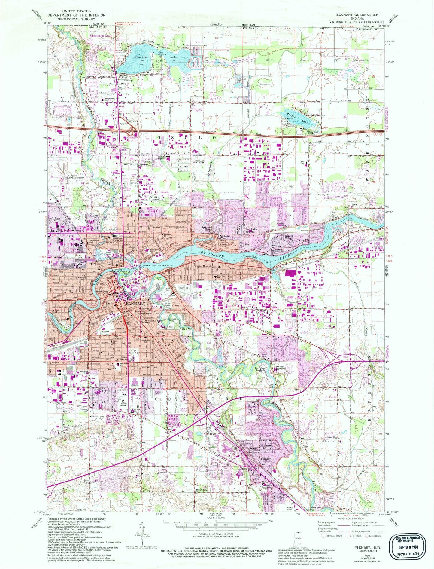
Historical USGS topographic quad map of Elkhart in the state of Indiana. Map scale may vary for some years, but is generally around 1:24,000. Print size is approximately 24" x 27"
This quadrangle is in the following counties: Elkhart.
The map contains contour lines, roads, rivers, towns, and lakes. Printed on high-quality waterproof paper with UV fade-resistant inks, and shipped rolled.
Contains the following named places: Albright Church, American Park, Baldwin Church, Beardsley Elementary School, Christiana Creek, City of Elkhart, Concord Central School, Concord South Side Elementary School, Concord Township Fire Department Station 1, De Camp Gardens, Dunlap, Dunlap Census Designated Place, East Lake Estates, East Side Consolidated School, Elkhart, Elkhart County Landfill, Elkhart Fire Department Central Station, Elkhart Fire Department Station 2, Elkhart Fire Department Station 3, Elkhart Fire Department Station 4, Elkhart Fire Department Station 5, Elkhart Fire Department Station 6, Elkhart Fire Department Station 7, Elkhart General Hospital, Elkhart Hydro Dam, Elkhart Municipal Airport, Elkhart Police Department, Elkhart Post Office, Elkhart Public Library, Elkhart Public Library Osolo Branch, Elkhart Public Library Pierre Moran Branch, Elkhart River, Elkhart Valley Church, Garden Village, Grace Church, Grace Lawn Cemetery, Greenleaf Manor, Hawthorne Elementary School, Heaton Lake, Hillcrest Church, Island Park, Lincoln Elementary School, Mary F Beck Elementary School, Mary Feeser Elementary School, Mather Ditch, McCoy Memorial Church, McNaughton Park, Middlebury Elementary School, Midway Airport, Monger Elementary School, Moran Park, North Side Junior High School, Northside Church, Osolo Elementary School, Osolo Emergency Medical Services, Osolo Township Ditch, Osolo Township Fire Department, Pierre Moran Middle School, Pine Creek, Prairie Street Cemetery, Puterbaugh Creek, Rice Cemetery, Rice Park, Rice School, Riverview Church, Riverview Elementary School, Riverview Park, Roosevelt Elementary School, Rowe Cemetery, Saint Johns Church, Saint Thomas the Apostle School, Saint Vincent de Paul Elementary School, Saint Vincent DePaul School, Samuel Strong School, Shady Nook Chapel, Simonton Lake Census Designated Place, Studebaker Park, Sugar Grove Church, Township of Concord, Township of Osolo, Trinity Church, Ullery School, Weeber Farms, West Side School, Weston School, Willowdale School, WTRC-AM (Elkhart), Yellow Creek, ZIP Codes: 46514, 46516, 46517