MyTopo
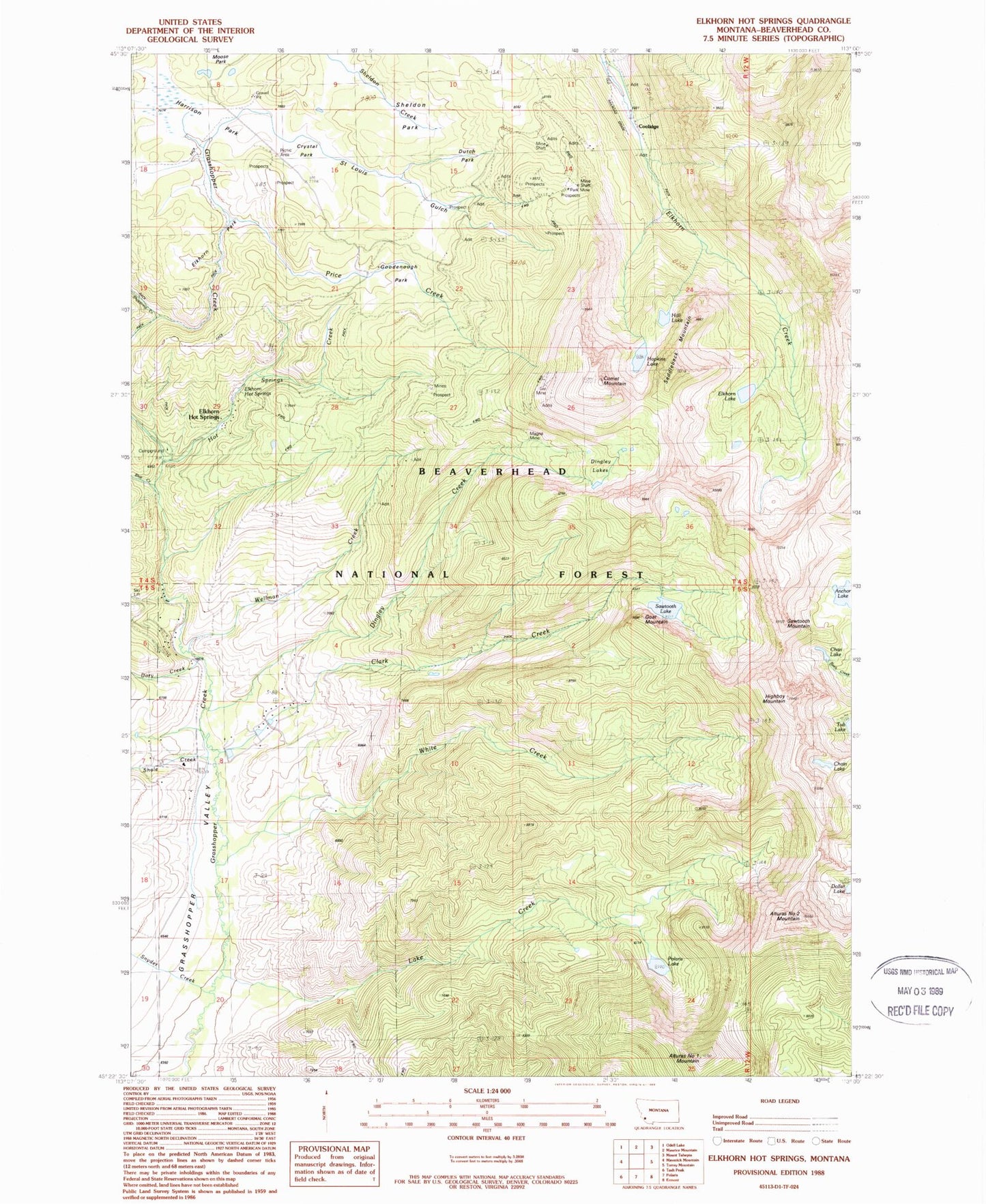
Classic USGS Elkhorn Hot Springs Montana 7.5'x7.5' Topo Map
Couldn't load pickup availability
Historical USGS topographic quad map of Elkhorn Hot Springs in the state of Montana. Typical map scale is 1:24,000, but may vary for certain years, if available. Print size: 24" x 27"
This quadrangle is in the following counties: Beaverhead.
The map contains contour lines, roads, rivers, towns, and lakes. Printed on high-quality waterproof paper with UV fade-resistant inks, and shipped rolled.
Contains the following named places: Alturas Number One Mountain, Alturas Number Two Mountain, Anchor Lake, Blue Creek, Chan Lake, Clark Creek, Comet Mountain, Crystal Park, Dingley Creek, Dingley Lakes, Dollar Lake, Dory Creek, Driveway Trail, Dutch Park, Elkhorn, Elkhorn Hot Springs, Elkhorn Lake, Elkhorn Park, Elkhorn Hot Springs, Elkhorn Upper Camp, Gar Mine, Goat Mountain, Goodenough Park, Hall Lake, Harrison Park, Highboy Mountain, Hopkin Lake, Hot Springs Creek, Lake Creek, Magna Mine, Old Elkhorn Mine, Ore Mill, Park Mine, Polaris Lake, Price Creek, Rhubarb Patch Trail, Saddleback Mountain, Saint Louis Gulch, Sawtooth Lake, Sawtooth Mountain, Shale Creek, Sheldon Park, Shoestring Creek, Snyder Creek, Wellman Creek, Wellman Mine, White Creek, Coolidge, Upper Elkhorn Camp, Elkhorn Ore Mill, Grasshopper Campground, Grasshopper Campground, Elkhorn Forest Service Station (historical), Crystal Park Picnic Area, Chain Lake, Elkhorn Mill Mine, Blue Eyed Annie Mine, Aspen Mine, Lost Cloud Mine, Copper Queen Mine, Gar Mine, Park Mine, Upper Elkhorn Mine, Old Elkhorn Mine, Boatman Lake Mine, Guy Mine, Magna Mine, 05S12W17CBBA01 Well, 05S12W08CBAA01 Well, 05S12W08AADC01 Well, 04S12W29CCCA01 Well, 04S12W29ACC_01 Spring, Aurora Post Office (historical), Maverick Mountain RV Park, Coolidge Post Office (historical), Coolidge (historical), Coolidge School (historical), Elkhorn School (historical), Grasshopper Valley Fire Department, Maverick Mountain Census Designated Place, Maverick Mountain, Alturas Number One Mountain, Alturas Number Two Mountain, Anchor Lake, Blue Creek, Chan Lake, Clark Creek, Comet Mountain, Crystal Park, Dingley Creek, Dingley Lakes, Dollar Lake, Dory Creek, Driveway Trail, Dutch Park, Elkhorn, Elkhorn Hot Springs, Elkhorn Lake, Elkhorn Park, Elkhorn Hot Springs, Elkhorn Upper Camp, Gar Mine, Goat Mountain, Goodenough Park, Hall Lake, Harrison Park, Highboy Mountain, Hopkin Lake, Hot Springs Creek, Lake Creek, Magna Mine, Old Elkhorn Mine, Ore Mill, Park Mine, Polaris Lake, Price Creek, Rhubarb Patch Trail, Saddleback Mountain, Saint Louis Gulch, Sawtooth Lake, Sawtooth Mountain, Shale Creek, Sheldon Park, Shoestring Creek, Snyder Creek, Wellman Creek, Wellman Mine, White Creek, Coolidge, Upper Elkhorn Camp, Elkhorn Ore Mill, Grasshopper Campground, Grasshopper Campground, Elkhorn Forest Service Station (historical), Crystal Park Picnic Area, Chain Lake, Elkhorn Mill Mine, Blue Eyed Annie Mine, Aspen Mine, Lost Cloud Mine, Copper Queen Mine, Gar Mine, Park Mine, Upper Elkhorn Mine, Old Elkhorn Mine, Boatman Lake Mine, Guy Mine, Magna Mine, 05S12W17CBBA01 Well, 05S12W08CBAA01 Well, 05S12W08AADC01 Well, 04S12W29CCCA01 Well, 04S12W29ACC_01 Spring, Aurora Post Office (historical), Maverick Mountain RV Park, Coolidge Post Office (historical), Coolidge (historical), Coolidge School (historical), Elkhorn School (historical), Grasshopper Valley Fire Department, Maverick Mountain Census Designated Place, Maverick Mountain