MyTopo
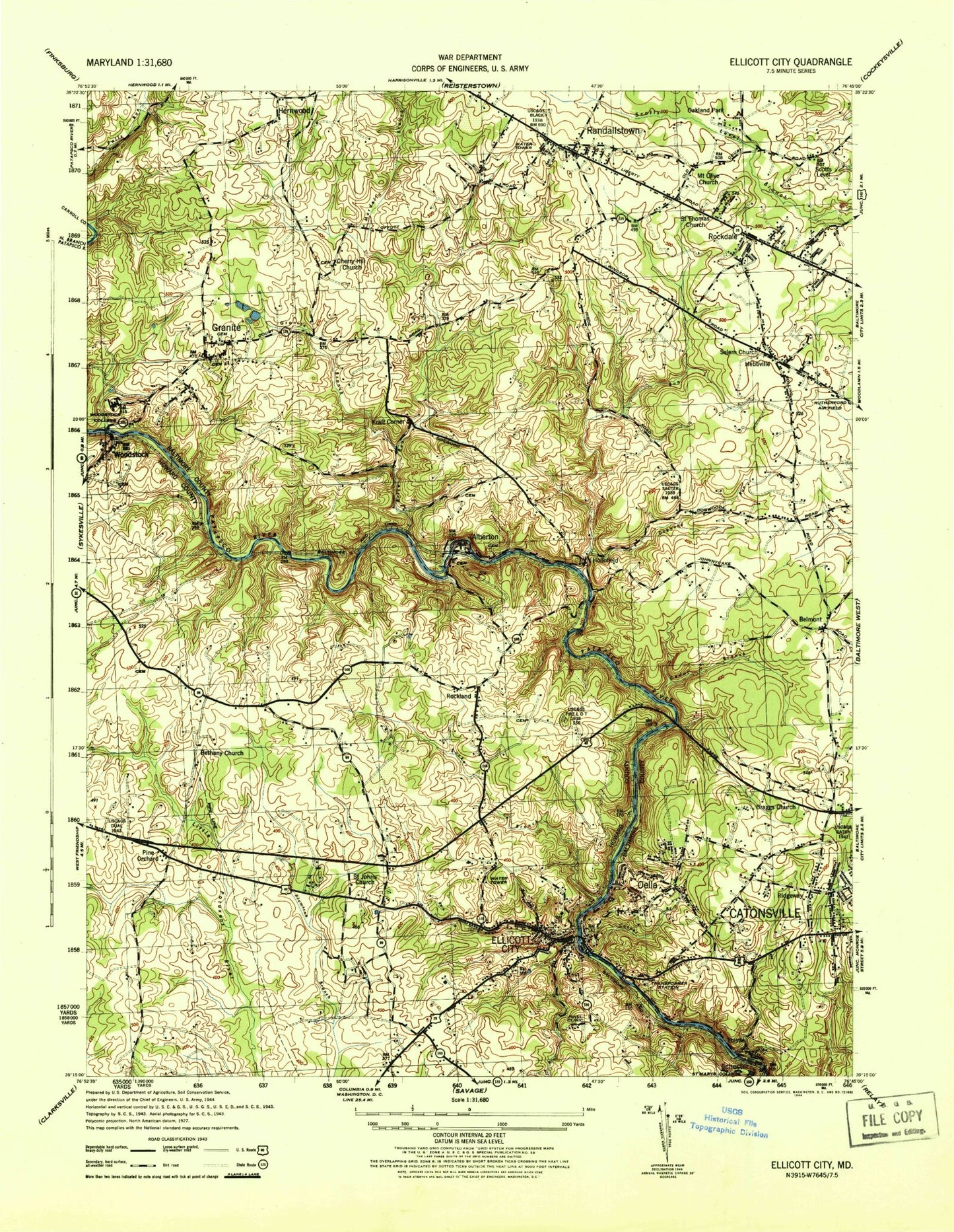
Classic USGS Ellicott City Maryland 7.5'x7.5' Topo Map
Couldn't load pickup availability
Historical USGS topographic quad map of Ellicott City in the state of Maryland. Typical map scale is 1:24,000, but may vary for certain years, if available. Print size: 24" x 27"
This quadrangle is in the following counties: Baltimore, Carroll, Howard.
The map contains contour lines, roads, rivers, towns, and lakes. Printed on high-quality waterproof paper with UV fade-resistant inks, and shipped rolled.
Contains the following named places: Bens Run, Bethany United Methodist Church, Bihy Cemetery, Brice Run, Cedar Branch, Cherry Hill Church, Cooper Branch, Daniels, Davis Branch, Davis Tunnel, Dogwood Run, Ellicott City, Emmerts Church, Good Shepherd Cemetery, Granite Branch, Hollofield Tower, Little Flower School, Mardella Branch, Milford Mill Academy, Miller Run, Mount Olive Church, Patapsco State Park, Saint Johns Church, Saint Marys College, Saint Stanislaus Church, Sucker Branch, Sylvan Dell Valley, Union Bethel African Methodist Episcopal Church, Union Dam, Woodstock College (historical), Ilchester, Belmont, Chestnut Hill, Granite, Gray, Hebbville, Hernwood, Hollofield, Kraft Corner, Oakland Park, Oella, Pine Orchard, Randallstown, Ridgeway, Rockdale, Rockland, Scotts Level, Thistle, Woodstock, Catonsville Middle School, Adil Meadows, Ascension Prince of Peace Episcopal Church, Northwest Hospital Center, Belle Farm Estates, Braggs Church (historical), Brenbrook Plaza Shopping Center, Carriage Hill Village, Carriage Hills Park, Catonsville Gateway, Catonsville Park, Chadwick Elementary School, Chadwick Manor, Chadwick Shopping Center, Chalfone Manor, Church Lane Elementary Technology School, Colonial Gardens, Congregation Beth Israel, Crown Estates Park, Diamond Ridge Golf Course, Drexel Woods, Fair Brook, Fields of Harvest, First Church of Christ Scientist, Forty West Shopping Center, Frederick Village, Gilson Park, Granite Presbyterian Church, Grays Level, Green Sanctuary Memorial Park Cemetery, Hebbville Elementary School, Heraldry Square, Hernwood Elementary School, Hernwood Sanitary Landfill, Hood Mill (historical), Inwood Shopping Center, Kings Park, Kingswood Common, Liberty Court Shopping Center, Liberty Manor, Liberty Plaza Shopping Center, Lynn Acres, Mardella Run, Merrymount, Milford Mill Shopping Center, Milford Shopping Center, Oakwood Village, Offutt Ridge, Old Court Middle School, Our Lady of Perpetual Help School, Parkview Trail, Pike Park Plaza Shopping Center, Pike Park Plaza South Shopping Center, Randall Ridge, Randallstown Elementary School, Randallstown Plaza Shopping Center, Randallstown Post Office, Rockdale Park, Rockwell, Rolling Heights, Rolling Park, Rolling Ridge, Rutherford Business Center, Saint Alphonsus Church, Saint Paul Evangelical Lutheran Church, Saint Paul School, Salem Church, Scotts Branch Elementary School, Scotts Level Park, Stevenswood, Temple Emanuel, Timber Point, Trinity United Methodist Church, Waterford Place, Westchester, Westerlee, Willow Glen North Park, Winand Elementary School, Windwood, Winfield Elementary School, Winsten Estates, Woodbridge Elementary School, Woodbridge Valley, Damiels Dam, Union Dam, Patapsco River Lake, Mitchell Heliport, Pinel Clinic Hospital, WLIF-AM (Baltimore), WPOC-FM (Baltimore), WHSW-TV (Baltimore), WNUV-TV (Baltimore), Autumn Hill, Bethany Lane Baptist Church, Bethany Manor, Bethgate, Bethwood, Bethel Baptist Church, Centennial High School, Centennial Lane Elementary School, Chateau Valley, Chatham Mall Shopping Center, Chestnut Farms, Chestnut Hill, Chestnut Hill Estates, The Church of Jesus Christ of Latter Day Saints, Crestleigh, Cypressmeade Park, David W Force Park, Dorsey Hall, Dunloggin, Dunloggin Middle School, Dunloggin Park, Dunmoor Woods, Ellicott Center Industrial Park, Ellicott Mills Middle School, Fairway Hill, First Church of the Nazarene, First Evangelical Lutheran Church, Font Hill Manor, Font Hill Park, Forest Hill Swim Club, Fox Hill, Glen Brook, Brittany, Gray Rock, Gwynn Acres Park, High View Estates, Hilton (historical), Ivy Hill, Keywaydin, Linwood, Linwood Childrens Home, McAlpine, Miller Branch Howard County Library, Mount Hebron High School, Nob Hill, Nob Hill Swim Club, Normandy Heights, Normandy Shopping Center, Normandy Woods, Northfield Elementary School, O'Donnell, Oak Lea, Oak West, Open Bible Tabernacle, Patapsco Middle School, Patapsco Valley State Park Headquarters, Pine Orchard Church of the Brethren, Pine Orchard Park, Rockland Center School, Rolling Ridge, Saint Johns Cemetery, Saint John's Lane Elementary School, Saint Johns Manor, Saint Johns Plaza Shopping Center, Saint Johns Village, School Number 9 (historical), Stonecrest Hills, Sylvan Hill, Sheppard Pratt Hospital - Ellicott City, The Fairways, The Oaks, The Willows, Toll House, Turf Valley Overlook, Valley Meade, Village Green Shopping Center, Wallace Park, Alberton (historical), Allenford, Braebrooke, Brennan Convalescent Home (historical), Brinkleigh, Brinkleigh Manor, Burleigh Manor, Centennial Manor, Chamberlea, Chapelview, Chateau Ridge, Chatham, Chatham Gardens, Church of the Resurrection, Davis (historical), Dorseys Run (historical), Ellicott City Historic District, Ellicott City Post Office