MyTopo
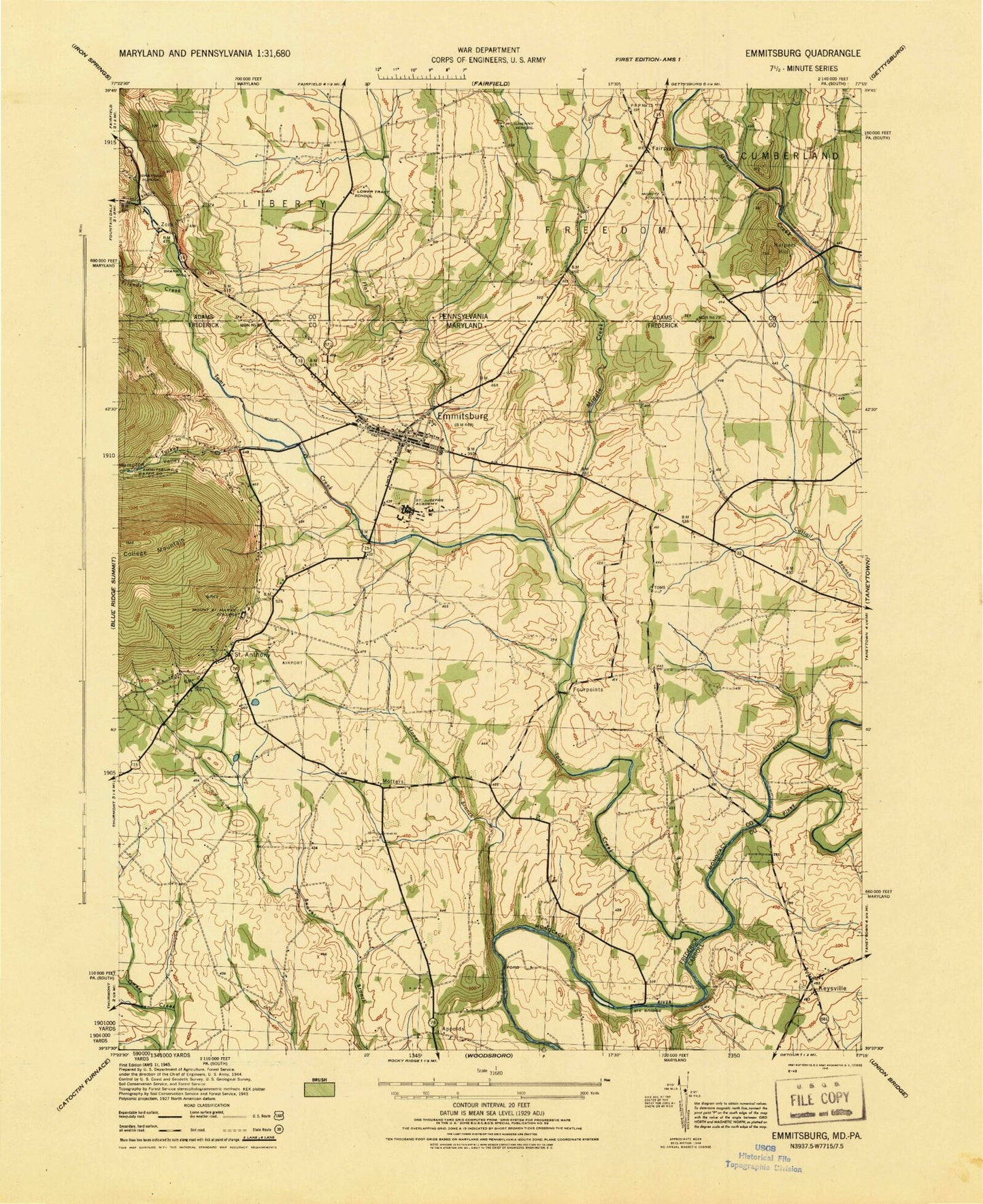
Classic USGS Emmitsburg Maryland 7.5'x7.5' Topo Map
Couldn't load pickup availability
Historical USGS topographic quad map of Emmitsburg in the states of Maryland, Pennsylvania. Map scale may vary for some years, but is generally around 1:24,000. Print size is approximately 24" x 27"
This quadrangle is in the following counties: Adams, Carroll, Frederick.
The map contains contour lines, roads, rivers, towns, and lakes. Printed on high-quality waterproof paper with UV fade-resistant inks, and shipped rolled.
Contains the following named places: Appolds, Barrett Hall, Bell Airport, Blackberry Hills, Bollinger Heights, Bollinger School, Borders Learning Center, Bullock, Bush Horner Branch, Carroll View, Catoctin Crosswind Airport, Catoctin View Christian School, Cedar Rowe Quarter Horse Farm, Chapel of the Immaculate Conception, Church of the Incarnation United Church of Christ, Coad Science Building, Cogan Student Union Building, Crystal Fountain Farms, Dinterman, District 5 Emmitsburg, Elder Cemetery, Elias Cemetery, Elias Lutheran Church, Emmit Ridge, Emmitsburg, Emmitsburg Ambulance Company Number 26, Emmitsburg Branch Library, Emmitsburg Cemetery, Emmitsburg Community Park, Emmitsburg Elementary School, Emmitsburg Library, Emmitsburg Police Department, Emmitsburg Post Office, Emmitsburg School, Emmitsburg Volunteer Ambulance Company Station 26, Fairplay, Flat Run, Flynn Hall, Four Points Bridge, Fourpoints, Friends Creek, Glass, Grace Church, Grace United Church of Christ, Groff's Content Farm, Hampton Valley, Harney Venture Estates, Harpers Hill, Jones, K Section Dam, K Section Pond, Keysville, Keysville Evangelical Lutheran Church, Keysville Union Church, Knott Academic Center, Knott Athletic Recreational and Convocational Complex, Knott Athletic Recreation Convocation Complex, Liberty Township Police Department, Longs, Marion Burk Knott Auditorium, Memorial Gymnasium, Middle Creek, Miney Branch, Moritz School, Mother Seton Elementary School, Motters, Motters Run, Mount Saint Mary's University, Mount Saint Mary's University Department of Public Safety, Mountain Manor Treatment Center Emmitsburg, Mountain View Cemetery, Mozinger, National Emergency Training Center, National Shrine of Saint Elizabeth Ann Seton, Northgate, Old Mount Saint Marys Cemetery, Pangborn Hall, Phillips Library, Piney Creek, Randallstown Precinct Number 2 Substation, Saint Anthony, Saint Anthony Shrine Roman Catholic Church, Saint Catherine's Nursing Center, Saint Elias Cemetery, Saint Joseph Catholic Church, Saint Joseph High School, Saint Josephs Cemetery, Saint Josephs College, Saint Mary Run, Section F Dam, Shanks Mill, Sheridan Hall, Silo Hill, Sixes Bridge, Snowden, Stonehurst, Stony Branch, Stouter, Terra Rubra Farm, The Grotto of Lourdes, The Terrace, Thornbrook, Toms Creek, Toms Creek Church, Toms Creek Methodist Cemetery, Town of Emmitsburg, Trinity United Methodist Church, Troxel, Turkey Creek, Twin Oaks Dairy, Union Cemetery, Vigilant Hose Company Number 6, Vigilant Hose Company Station 6, Washington School, Willow Rill, Willowdale Farms, Wivell Estates, WMTB-FM (Emmitsburg), Woodland Heights, Zora, ZIP Code: 21727