
MyTopo
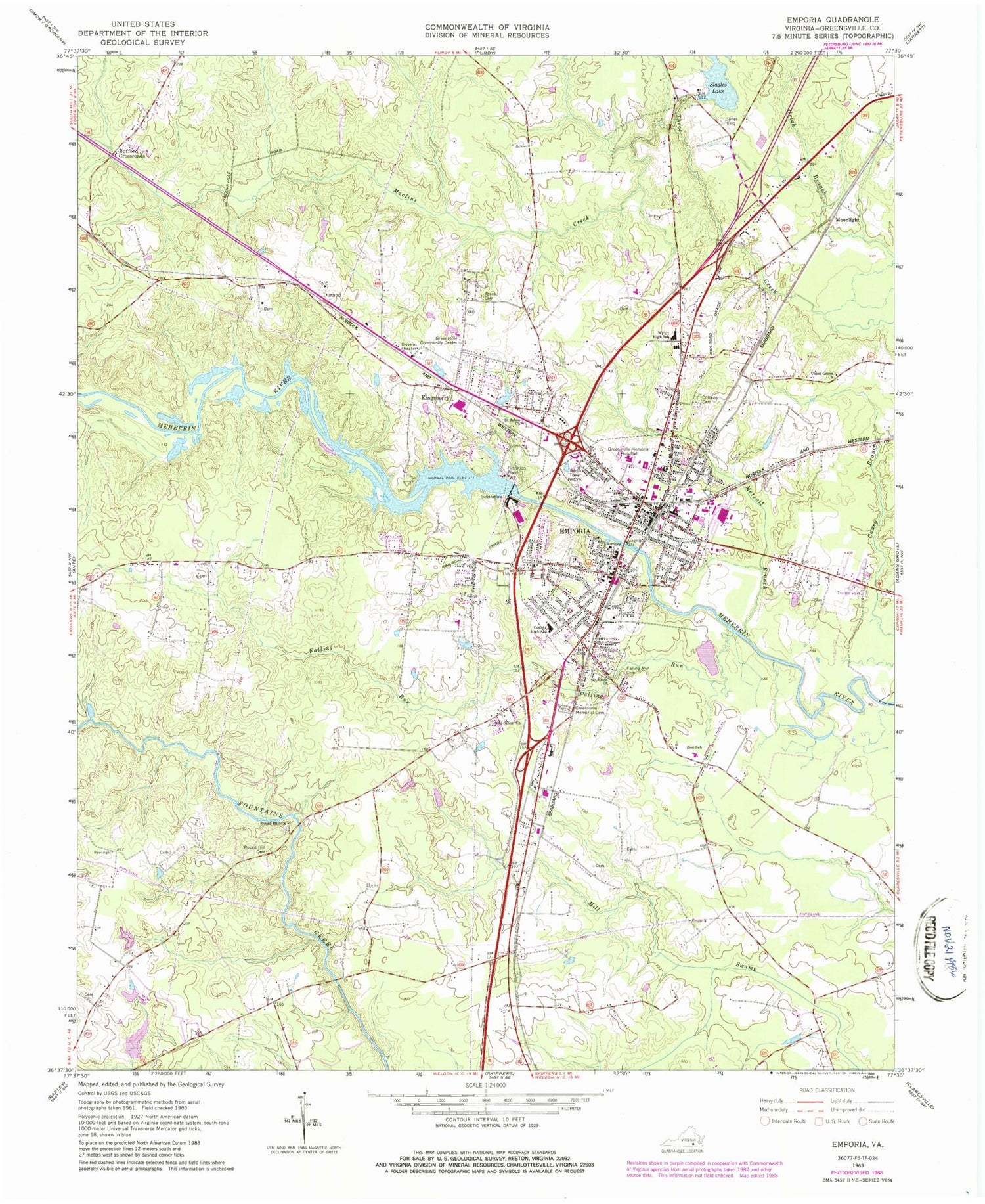
Classic USGS Emporia Virginia 7.5'x7.5' Topo Map
Couldn't load pickup availability
Historical USGS topographic quad map of Emporia in the state of Virginia. Map scale may vary for some years, but is generally around 1:24,000. Print size is approximately 24" x 27"
This quadrangle is in the following counties: Emporia (city), Greensville, Southampton.
The map contains contour lines, roads, rivers, towns, and lakes. Printed on high-quality waterproof paper with UV fade-resistant inks, and shipped rolled.
Contains the following named places: A B Adams Convalescent Center, Apostolic Faith Church, Baltimore Baptist Church, Belfield Elementary School, Belfield Magisterial District, Belfield Marketplace Shopping Center, Bible Baptist Independent Missionary Church, Bufford Crossroads, Calvary Baptist Church, Christ Episcopal Church, Church of God, Church of God of Prophecy, Church of the Holy City, City of Emporia, District 3, Dons Mobile Home Park, Durand, Edward W Wyatt Middle School, Emporia, Emporia Assembly of God Church, Emporia Cemetery, Emporia City Sheriff's Office, Emporia Dam, Emporia Elementary School, Emporia Executive Center, Emporia Industrial Park, Emporia Lake, Emporia Municipal Building, Emporia Police Department, Emporia Post Office, Emporia Shopping Center, Emporia Volunteer Fire Department, Emporia Waste Water Treatment Plant, Emporia Waterworks, Faith Baptist Church, Falling Run, Falling Run Cemetery, Falling Run Waste Water Treatment Plant, First Presbyterian Church, Forest Church, Forest Lawn Memorial Gardens, Glorious Church of God in Christ Apostolic, Greens Chapel Number Two Reformed Zion Union Apostolic Church, Greensville Community Center, Greensville County, Greensville County Courthouse, Greensville County Health Center, Greensville County High School, Greensville County Industrial Park, Greensville County Jail, Greensville County Sheriff's Office, Greensville County Technical Center, Greensville County Training School, Greensville County-Emporia Historical Museum, Greensville Elementary School, Greensville Memorial Cemetery, Greensville Memorial Hospital, Greensville Memorial Hospital Heliport, Greensville Volunteer Rescue Squad, Greenwood Park, Halifax Manor Mobile Home Park, Hicksford Elementary School, Jones Cemetery, Kingdom Hall of Jehovahs Witnesses, Kingsberry, Lakeside Village Mobile Home Park, Lanes Corner, Lifestar Ambulance Service Emporia, Lincoln Heights, Little Salem Church, Living Waters Rock Church, Maclins Creek, Magnums Mobile Home Park, Main Street Baptist Church, Main Street United Methodist Church, Meherrin Dialysis Center, Meherrin River Park, Meherrin River Reservoir, Metcalf Branch, Monumental United Methodist Church, Moonlight, Mount Olive Baptist Church, North Emporia, Parhams Farm, Pine View Mobile Home Park, Prince Squire Medical Center, Richardson Memorial Library, Rising Sun Holiness Church, Rockbridge School, Round Hill Cemetery, Round Hill Church, Royal Baptist Church, Saint James Episcopal Church, Saint John Inspirational Pentecostal Church, Saint Johns Church, Saint Johns Holy Mission, Saint Pauls Church, Saint Richards Catholic Church, Slagles Dam, Slagles Lake, Slagles Mill, Southern Grove Farms, Southern Virginia Regional Medical Center, Southside Regional Jail, Southside Square Shopping Center, Southside Virginia Community College - Wrenn Campus, Three Creek Waste Water Treatment Plant, Union Grove Church, Veterans Memorial Park, Village View, Virginia State Police Division 5 Area 35 Office, Walnut Heights, Washington Park, Westover Hills, WEVA-AM (Emporia), WEVA-FM (Emporia), White Chapel Church of God in Christ, White City, Zion Alternative Education Center, ZIP Code: 23847


