MyTopo
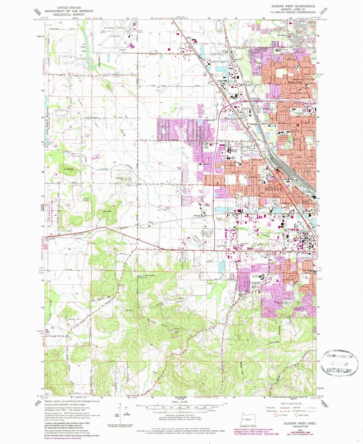
Classic USGS Eugene West Oregon 7.5'x7.5' Topo Map
Couldn't load pickup availability
Historical USGS topographic quad map of Eugene West in the state of Oregon. Map scale may vary for some years, but is generally around 1:24,000. Print size is approximately 24" x 27"
This quadrangle is in the following counties: Lane.
The map contains contour lines, roads, rivers, towns, and lakes. Printed on high-quality waterproof paper with UV fade-resistant inks, and shipped rolled.
Contains the following named places: Acorn City Park, Allison Park Christian Church, Amazon Creek Diversion Channel, Arrowhead City Park, Awbrey Park Elementary School, Bailey Hill, Bailey Hill Instructional Center, Balboa Park, Balboa Park Drag Strip, Berkeley City Park, Bethel, Bethel Branch Library, Bethesda Lutheran Church, Bramblewood City Park, Burma, Candlelight City Park, Cantrell Hill, Carmel of Maria Regina Monastery, Cascade Middle School, Churchill High School, Churchill Sports Park, City View Reservoir, Clear Lake, Clear Lake Elementary School, Crabtree Hill, Danebo, Danebo Elementary, Department of Motor Vehicles Eugene, Emerald Park, Empire Park, Enid, Eugene Fire Department Airport Station 12, Eugene Fire Station 10 Bailey Hill Station, Eugene Fire Station 11Santa Clara Station, Eugene Fire Station 7 Bethel Station, Eugene Fire Station 8 Danebo Station, Eugene Professionsal Rodeo Oregon Horse Center, Eugene Speedway, Eugene Yard, Eugene-Springfield Division, Fairfield Elementary, Finn, Fir Butte, Fir Grove, Fox Valley Lumber Company, Gilbert City Park, Golden Gardens City Park, Grace Baptist Church, Greenacres Golf Range, Hawkins Heights City Park, Hawkins Hill Reservoir, Howard Elementary School, Irving, Irving Elementary School, Irving Post Office, Irwin City Park, Kalapuya High School, Kelly Middle School, Kennedy Middle School, Lane College, Lane Memorial Gardens - Lane Memorial Funeral Home, Lane Rural Fire and Rescue Station 51, Lane School, Lane Substation, Lane Transit District Park and Ride, Lane Transit District River Road Transit, Lane Transit District Seneca Station, Lark Park, Lasen, Lifegate Christian Middle and High School, Mahlon Sweet Field, Malabon, Malabon Elementary School, Mangan City Park, Mayard, McCornack Elementary School, Meadow View School, Melvin Miller City Park, Mulkey Cemetery, Murray Hill, New Hope Christian College, North End Lumber Company, North Eugene High School, O E Ry Crossing, Oak Hill, Oak Hill Cemetery, Oregon Air and Space Museum, Petersen City Park, Prairie Mountain School, Red Cross Oregon Pacific Chapter Office, River Road, River Road Census Designated Place, River Road Post Office, Ross, Saint Matthews Episcopal Church, Saint Peters School, Santa Clara, Santa Clara Census Designated Place, Santa Clara Elementary School, Santa Clara Rural Fire Protection District Station 1, Santa Clara Rural Fire Protection District Station 2, Seneca, Shasta Middle School, Skyview City Park, Spring Creek Elementary School, State Street City Park, Trainsong City Park, Transfer, Walnut Grove City Park, Wellspring Friends School, West Lawn Memorial Park, West Side Post Office, Willamette High School, Willow Corner City Park, Willow Creek, Yujin Gakuen Elementary School, Zinker Reservoir, ZIP Codes: 97402, 97404