MyTopo
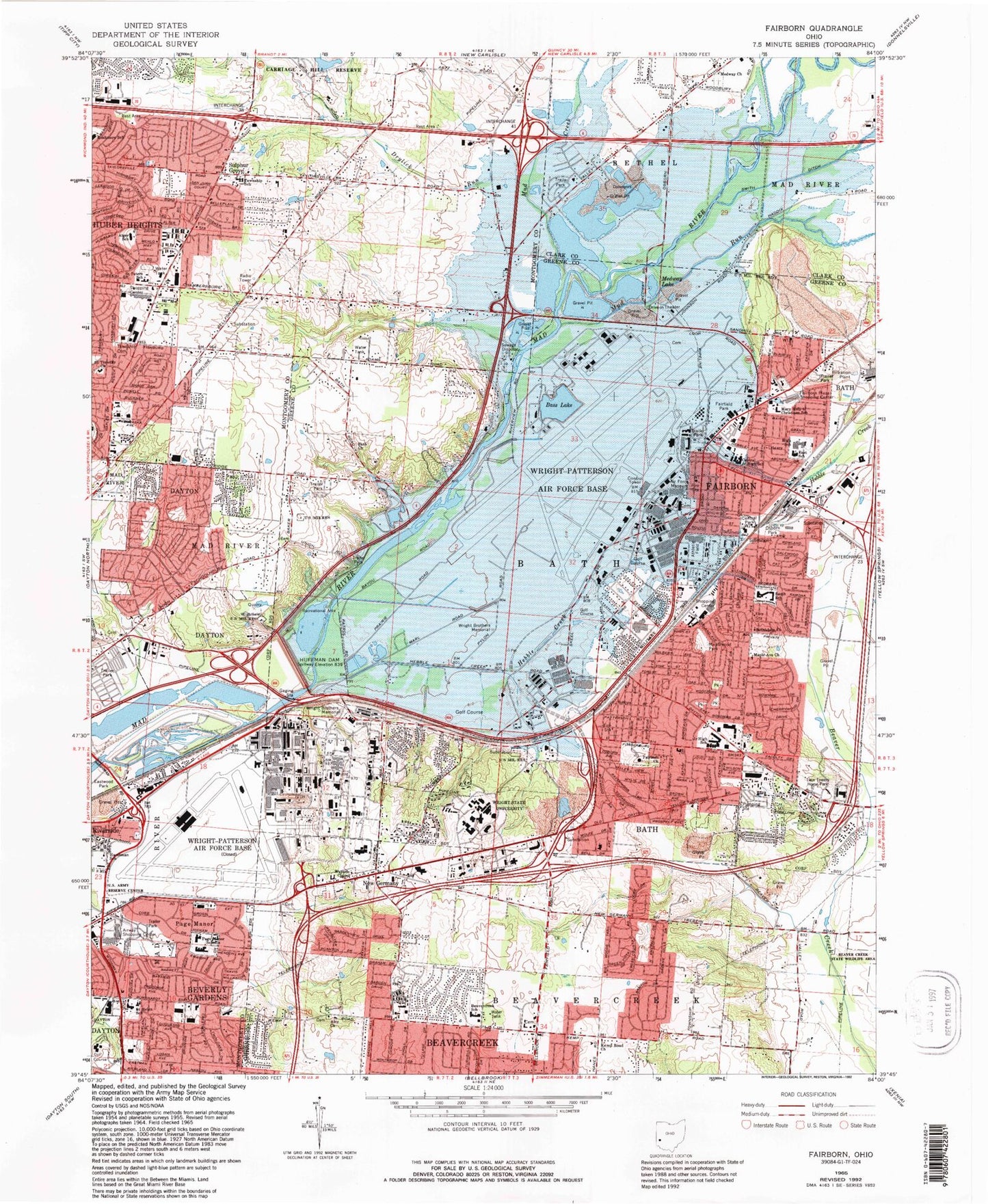
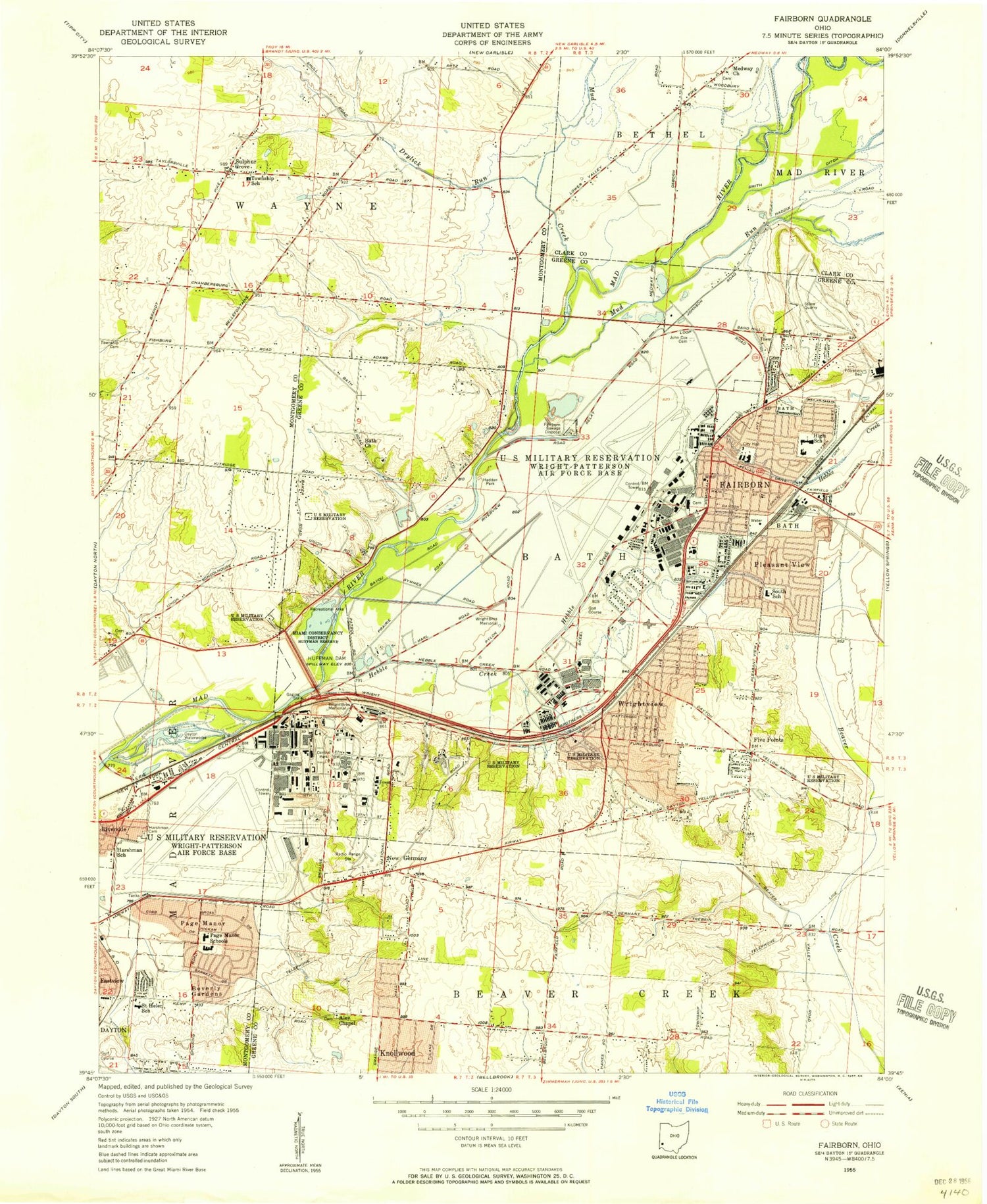
Classic USGS Fairborn Ohio 7.5'x7.5' Topo Map
Couldn't load pickup availability
Historical USGS topographic quad map of Fairborn in the state of Ohio. Typical map scale is 1:24,000, but may vary for certain years, if available. Print size: 24" x 27"
This quadrangle is in the following counties: Clark, Greene, Montgomery.
The map contains contour lines, roads, rivers, towns, and lakes. Printed on high-quality waterproof paper with UV fade-resistant inks, and shipped rolled.
Contains the following named places: Airway Church, Airway Shopping Center, Bass Lake, Bath Church, Central Junior High School, Central Park, Drylick Run, Fairborn Plaza Shopping Center, Harshman School, Huffman Dam, Kemp Road Church, Medway Church, Medway Lake, Mud Creek, Osborn Park, Page Manor Schools, Saint Helen School, Saint Peters School, Saint Timothy Church, Smith Ditch, Wayside Chapel, Wright Brothers Memorial, Huber Heights, New Germany, Page Manor, First Presbyterian Church of Fairborn, First Baptist Church of Fairborn, Mary Help of Christians Catholic Church, Grand Avenue Baptist Church, Trinity United Church of Christ, First Church of the Nazarene, Saville Park, Mary Help of Christians School, Baker Junior High School, Skyway Shopping Plaza Shopping Center, 88th Medical Group Wright Patterson Air Force Base, Liberty Missionary Baptist Church, Wright View Church of the Nazarene, South Fairborn Baptist Church, Fairborn Enterprise Baptist Church, First Assembly of God Church, Central Avenue Church of Christ, Palmer Elementary School, Wedgewood Park, Fairborn High School, Twin Towers Horse Park, Five Points Junior High School, Five Points Elementary School, Church of Christ, Wright Elementary School, Wartinger Park, Spicer Park, Spicer Heights Shopping Center, Grangeview Park, Trinity United Church of Christ, Titus Elementary School, Saint Helen Catholic Church, Beverly Gardens Elementary School, Spinning Hills Middle School, Alger School, Carriage Hill Reserve, Sulphur Grove, Park Hills Shopping Center, Maple Avenue Church, Wright State University, Huber Centre Shopping Center, Marian Meadows Shopping Center, Lofinos Plaza Shopping Center, Spin-Kemp Shopping Center, East Plaza Shopping Center, Page Manor Shopping Center, Huber Heights Baptist Temple, Beavercreek School, Bethlehem Lutheran Church, Fairborn Church, Saint Marks Lutheran Church, Aley United Methodist Church, Saville Elementary School, Saint Peter Catholic Church, Interstate Industrial Park, Rushmore Park, Brandt Tower Plaza Shopping Center, Goldmans Shopping Center, Gem City Shopping Center, Wrightgate Industrial Park, Valley Intercity Industrial Park, Shellabarger Park, Aley Cemetery, Cottonwood Park, Wrightview, Hebble Creek, Rohrers Island, Beverly Gardens, Five Points, Huffeysville (historical), Pleasant View, Simms (historical), Huffman Reservoir, Mud Run, Riverside, Fairborn, East Elementary School, Rushmore Elementary School, South Elementary School, Fairborn Post Office, Rogers Heliport, The Farm Heliport, Dayton Aviation Heritage National Historical Park, Five Points Plaza Shopping Center, University Shoppes Shopping Center, Fairway Terrace Mobile Home Park, Allyn Hall, Brehm Laboratory, Creative Arts Center, Fawcett Hall, Frederick A White Center, Hamilton Hall, Millet Hall, Oelman Hall, Rike Hall, University Center, Beaver Creek State Wildlife Area, Buckeye Mobile Home Park, Community Park East, Ervin J Nutter Center, Fairborn-Wright Office Park, Fairfield Park, Huber Mobile Home Park, Huffman Prairie National Historic Landmark, Patterson Park, Red Oak Mobile Home Park, Sandhill Road Park, Shawnee Park, South Point Village Mobile Home Park, Tecumseh Park, Thomas Trailer Park, Upper Valley Trailer Court, Valle Greene Park, Veterans Memorial, Womacks Mobile Home Park, Woodland Hills, Wright Executive Center, Wright School Park, Huber Heights First Baptist Church, WWSU-FM (Fairborn), Township of Bath, City of Huber Heights, Township of Mad River, Dille Cemetery, Harshman Cemetery, Kemp Cemetery, Shearer Cemetery, Bath Cemetery, Cox Cemetery, Fairfield Cemetery, Gerlaugh Cemetery, Mitman Cemetery, Sunnyside Cemetery, Union Schoolhouse Cemetery, Sulphurgrove Post Office (historical), Wright-Patterson Air Force Base Census Designated Place, City of Fairborn, Township of Wayne, City of Riverside, Wright-Patterson Air Force Base, Wright-Patterson Air Force Base, Park Hills Crossing, Fairborn Mobile Home Park, Sherman's Trailer Park, Wright Patterson Mobile Home Park, Freedom Church, McMahan Mobile Home Park, Crown Village Mobile Park, Huber Heights Fire Department Station 22, Fairborn Fire Department Station 1, Fairborn Fire Department Station 4, Beavercreek Township Fire Department Station 63, Wright Patterson Air Force Base Fire / Emergency Medical Services Department, Skyborn Drive-In, Fairborn Aggregates Pit, Frank's Fruit Farm, Hillside Tree Farm, Fairborn City Police Department, Airway Road Post Office, WPAFB Unit 2 Post Office, Huber Heights Post Office, Wright Patt Carrier Annex Post Office, WPAFB Unit 3 Post Office, AMC Dayton Post Office