MyTopo
Classic USGS Fairmount Tennessee 7.5'x7.5' Topo Map
Couldn't load pickup availability
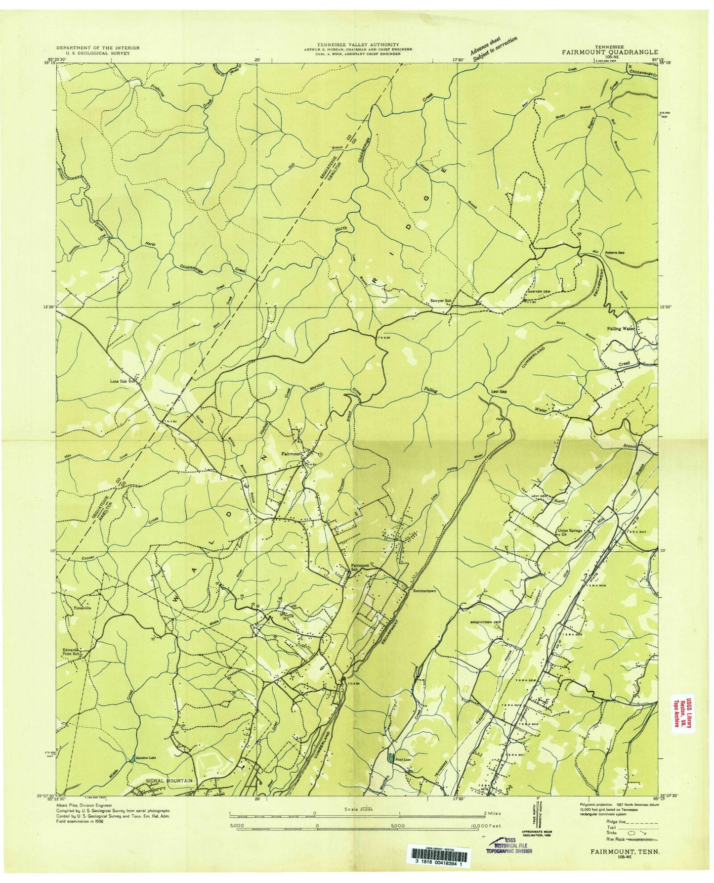
Historical USGS topographic quad map of Fairmount in the state of Tennessee. Typical map scale is 1:24,000, but may vary for certain years, if available. Print size: 24" x 27"
This quadrangle is in the following counties: Hamilton, Sequatchie.
The map contains contour lines, roads, rivers, towns, and lakes. Printed on high-quality waterproof paper with UV fade-resistant inks, and shipped rolled.
Contains the following named places: Cumberland Escarpment, Frederick Creek, Shepherd Forest, Short Creek, Signal Mountain Church, Signal Mountain Golf and Country Club, Skyline Park, Summertown, Taft Highway Church, The Hellican, The Horseshoe, Timesville, Union Chapel, Union Springs Church, Vandergriff Cemetery, W Road Church, Welcome Hill Church, Wolfpen Point, Frederick Creek, Adams Ridge, Applewood, Barker Ridge, Barker Spring, Big Bend, Boston Branch, Boston Branch Lake, Brock Creek, Brown Branch, Buck Knob, Bull Branch, Burnt Cabin Spring, Buzzard Point, Calvary Church, Chestnut Ridge, Chicken Hollow, Coal Bank Creek, Day Ona Heights Church, Devils Backbone, Double Bridges, Dowler Heights, Edwards Point, Eight Oak Ridge, Fairmount, Fairmount Branch, Falling Water, Falling Water Church, Falling Water Falls, Ford Gap, Forest Park, Freeman Ridge, Fruedenberg Creek, Fruedenberg Ridge, Gadd Ridge, Galaxy Heights, Hall Cemetery, Hatfield Creek, Hicks Branch, Hillandale Center, Hixson Branch, Hixson Camp, Hixson Church, Holly Branch, Hurricane Branch, Levi Cemetery, Levi Gap, Little Bend, Little Falling Water Creek, Log Cabin Chapel, Lone Oak, Mabbit Spring, Mailbox Hill, Maple Branch, Marshall Creek, McGrew Creek, Morrison Spring, Mount Carmel Church, Mountain Friendship Church, Mountain View Church, Muddy Branch, North Glen Estates, Northwoods, Oak Hill North, Pickett Gulf, Pine Ridge, Pinecrest Church, Prentice Cooper State Forest, Rainbow Lake, Read Spring, Roberts Cemetery, Roberts Gap, Rocky Branch, Rogers Creek, Round Knob, Saint Augustine Church, Sawyer Cemetery, Seed Tick Branch, Sequatchie Chapel, Service Branch, Standifer Creek, Stanley Branch, Timberlinks, Walden, Wayside Church, Bee Branch, Birnam Wood, Brimer Creek, Brown Chapel Cemetery, Delashmitt Road Church, Boston Branch Lake Dam, Lone Oak Elementary School, Grayson Ridge, Alpine Heights, Brynewood Park, Claridge, Cloverdale Estates, Cross Creek, Daytona Hills, Eastwood Acres, Forestdale, Golden Oaks Estates, Hiddenbrook, Laurel Creek, Metro Park, Montclair South, Morrison Springs, Mountainwood, Norcross Hills, Pine Hill, Plaza Hills, Read Lake, Signal Terrace, Springvale, Rustic Villa, Edwards Point, Bethel Bible School (historical), Calvary Christian School, Community Church, Dill Mine, Doc Spangle Mine, Edwards Point School, Fairmount School (historical), Falling Water Baptist Church, Falling Water Elementary School, Hixson Presbyterian Church, Montclair Golf Course, North Red Bank Baptist Church, Red Bank Presbyterian Church, Signal Bluff Church (historical), Signal Crest United Methodist Church, Signal Mountain Baptist Church, Signal Mountain Church of Christ, Signal Mountain Town Hall, Signal Mountain Junior High School, Tate Mine, Walden Town Hall, Signal Mountain United Methodist Church, Signal Plaza Shopping Center, Timesville Avenue Baptist Church, WJTT-FM (Red Bank), WDEF-FM (Chattanooga), WDOD-FM (Chattanooga), WSKZ-FM (Chattanooga), WCSO-FM (Signal Mountain), WDYN-FM (Chattanooga), WUTC-FM (Chattanooga), WDEF-TV (Chattanooga), WRCB-TV (Chattanooga), WTVC-TV (Chattanooga), WTCI-TV (Chattanooga), WRIP-TV (Chattanooga), Fairmount Cemetery, Alpine Baptist Church, Thrasher Elementary School, Alpine Crest Elementary School, Nathan L Bachman Elementary School, Sawyer Elementary School, Signal Mountain Division (historical), Richard Lewis Number Eight Mine, Signal Mountain Post Office, Fairmount Census Designated Place, Town of Walden, Town of Signal Mountain, Commissioner District 2, Commissioner District 8, Fair Meadows Mobile Home Park, Webb Trailer Court, Falling Water Census Designated Place, Lone Oak Census Designated Place, Mountain Creek Horse Farm, Signal Mountain Fire Department Station 1, Red Bank Fire Department Station Number 2, Dallas Bay Volunteer Fire Department and Rescue Station 3, Chattanooga Fire Department Station 22, Fairmount Orchard, Rockstack Falls, Signal Mountain Police Department, Walden Police Department, Flatrock Falls, Freudenberg Falls, Slider Falls, Cumberland Escarpment, Frederick Creek, Shepherd Forest, Short Creek, Signal Mountain Church, Signal Mountain Golf and Country Club, Skyline Park, Summertown, Taft Highway Church, The Hellican, The Horseshoe, Timesville, Union Chapel, Union Springs Church, Vandergriff Cemetery, W Road Church, Welcome Hill Church, Wolfpen Point, Frederick Creek, Adams Ridge, Applewood, Barker Ridge, Barker Spring, Big Bend, Boston Branch, Boston Branch Lake, Brock Creek, Brown Branch, Buck Knob, Bull Branch, Burnt Cabin Spring, Buzzard Point, Calvary Church, Chestnut Ridge, Chicken Hollow, Coal Bank Creek