MyTopo
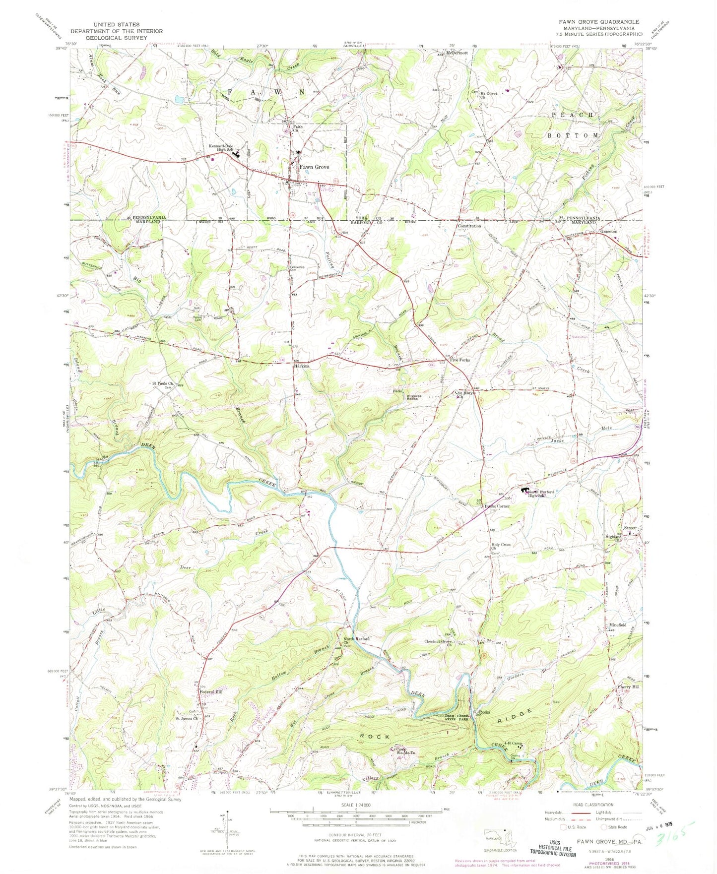
Classic USGS Fawn Grove Pennsylvania 7.5'x7.5' Topo Map
Couldn't load pickup availability
Historical USGS topographic quad map of Fawn Grove in the states of Pennsylvania, Maryland. Map scale may vary for some years, but is generally around 1:24,000. Print size is approximately 24" x 27"
This quadrangle is in the following counties: Harford, York.
The map contains contour lines, roads, rivers, towns, and lakes. Printed on high-quality waterproof paper with UV fade-resistant inks, and shipped rolled.
Contains the following named places: Belle Farm Heritage, Big Branch, Bobs Flow, Borough of Fawn Grove, Bushs Corner, Camp Wo-Me-To, Cattail Branch, Cherry Hill, Cherrywood Estates, Chestnut Grove Cemetery, Chestnut Grove Church, Children's Center of North Harford, Chrome Hill Estates, Church of Jesus Christ, Citizens Volunteer Fire Company Station 56, Clark Bridge, Clermont Mills, Coldstream, Constitution, Coventry Meadows, Deer Creek State Park, Deer Meadows, District 4 Marshall, Dunsen Heights, Eden Hills, Eden Mills Park, Faith Church, Falling Branch, Fawn Grove, Fawn Grove Post Office, Federal Hill, Federal Hill Heights, Federal Hill Post Office, Fellowship Church, Fellowship Methodist Episcopal Church Cemetery, Fifes Saw Mill, Fiore Winery, Five Forks, Four-H Camp Spring, Foxborough Nursery, Geneva Farms Golf Course, Gladden Branch, Graceton, Grier Nursery Farms, Griers Nursery and Greenhouses, Harford County Sheriff's Office Highland Community Policing, Harford Heritage, Harkins, Heaps Cemetery, Hidden Valley Girls Camp, Highland Cemetery, Highland Park, Highland Presbyterian Church, Highland Reading Center, Highland Ridge, Hoerr, Holy Cross Cemetery, Holy Cross Church, Island Branch, Jarrettsville Nursery, Kellogg Branch, Kennard-Dale High School, Kilgores Rocks, Links Airport, Little Creek Meadows, Little Deer Creek, Little Deer Creek Watershed Site Number 1 Dam, Loganville Fire Company Station Number 63, Madonna Hills, Madonna Landfill, McDermott, Meadowlark Estates, Midsummer Hill, Minefield, Molasses Mill, Mount Olivet Church, Nazarene Church, Nazarene School, Norrisville Seventh Day Adventist Church, Norrisville Volunteer Fire Company, North Bend Elementary School, North Bend Heights, North Harford Baptist Church, North Harford Cemetery, North Harford Church, North Harford Elementary School, North Harford Heights, North Harford High School, North Harford Middle School, Northampton, Orchard Valley Farms, Prestons Mill, Pylesville Census Designated Place, Quail Hills, Queen Annes Sheriff Sub Station South, Rock Hollow Branch, Rock Ridge, Rockridge Forest, Rocks, Rush Manor, Saint James Cemetery, Saint James Church, Saint Marys Cemetery, Saint Marys Church, Saint Pauls Cemetery, Saint Pauls Church, Spooners Creek, Spring Meadows, Stoneywood Nature Center, Street, Street Post Office, Twin Ridge Estates, Wet Stone Branch, Whispering Woods, Willwood, Wilsons Choice, Woodshed Village Shopping Center, ZIP Codes: 17321, 21132