MyTopo
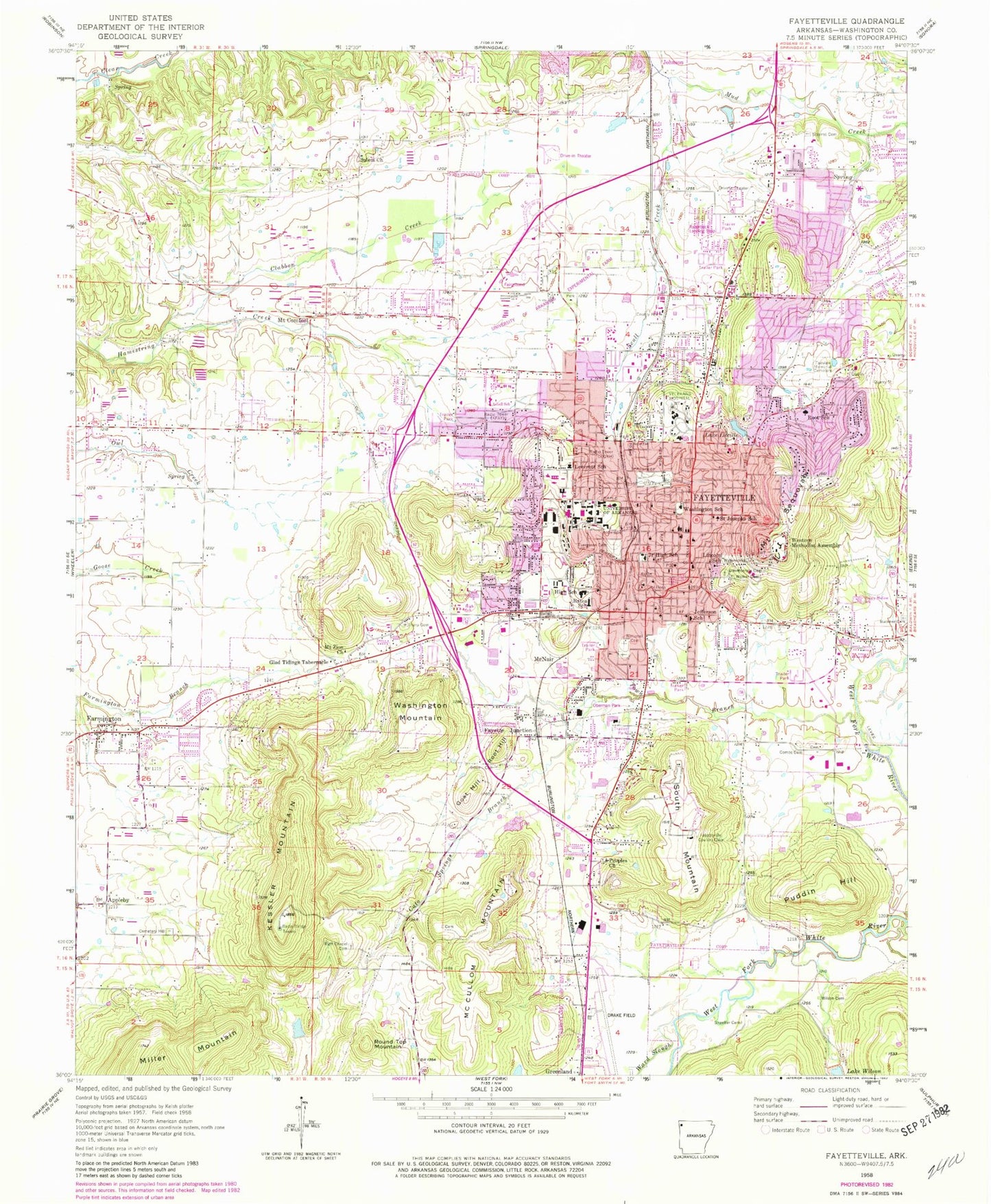
Classic USGS Fayetteville Arkansas 7.5'x7.5' Topo Map
Couldn't load pickup availability
Historical USGS topographic quad map of Fayetteville in the state of Arkansas. Typical map scale is 1:24,000, but may vary for certain years, if available. Print size: 24" x 27"
This quadrangle is in the following counties: Washington.
The map contains contour lines, roads, rivers, towns, and lakes. Printed on high-quality waterproof paper with UV fade-resistant inks, and shipped rolled.
Contains the following named places: Dowell Cemetery, Buckner Cemetery, Cato Springs Branch, Cemetery Hill Memorial Park, Combs Cemetery, Confederate Cemetery, Evergreen Cemetery, Fairview Memorial Cemetery, Glad Tidings Tabernacle, Hotz Park, Kessler Mountain, Lincoln School, Little Wildcat Creek, Mount Comfort, Mount Zion Church, Fayetteville National Cemetery, Peoples Church, Rieffs Chapel Cemetery, Salem Church, Shaeffer Cemetery, Stearns Cemetery, Sycamore Park, Tharp Cemetery, Town Branch, Walker Cemetery, Walker Park, Ward Slough, Wilson Cemetery, Appleby, Goat Hill, McCullom Mountain, Miller Mountain, Mount Sequoyah, Root Hill, Round Top Mountain, South Mountain, Washington Mountain, Asbell Park, Agricultural Park, Archias Mountain, Babe Ruth Ball Park, Baptist Student Center, Barbara (historical), Barnhill Arena, Butterfield Trail Park, Calvary Baptist Church, Center Street Church of Christ, Fayetteville Fire Department Station 1, Central Plaza, Central United Methodist Church, Chi Alpha Assembly of God Center, Christian Bible Center, College Avenue Baptist Church, Colonial Village Shopping Center, Combs Park, Covenant Presbyterian Church, Dowells Chapel (historical), Eastgate Shopping Center, Evelyn Hills Shopping Center, Fayetteville City Hall, Fayetteville City Hospital, Fayetteville High School, Fayetteville High School West, Fayetteville Industrial Park, Fiesta Square Shopping Center, Finger Park, Fayetteville Fire Department Station 2, Fayetteville Fire Department Station 3, Fayetteville Fire Department Station 4, First Baptist Church, First Christian Church, First United Presbyterian Church, George Cole Field, Gregory Park, Happy Hollow Park, Harmon Playground, Jefferson Park, Millsap Mountain, Mount Comfort Cemetery, Mount Nord Historic District, Mullins Library, Newman Catholic Student Center, North Street Church of Christ, Oak Plaza Shopping Center, Immanuel Baptist Church, Presbyterian-Christian Center, Raid Mountain, Razorback Golf Course, Razorback Stadium, Rieffs Chapel (historical), Robert Fulbright Public Library, Root Park, Saint Johns Lutheran Church, Saint Josephs Catholic Church, Saint Martins Episcopal University Center, Saint Pauls Episcopal Church, Saint Thomas Aquinas Catholic Church, Southgate Shopping Center, Trinity United Methodist Church, Unitarian Universalist Fellowship, University Baptist Church, Walker Park, Washington County Courthouse, Washington County Fairgrounds, Washington County Jail, Washington Park, Regency Hospital of Northwest Arkansas, Washington-Willow Historic District, Wesley Foundation United Methodist Campus Center, Westgate Shopping Center, Wilson Park, Paradise Valley Golf Course, Butterfield Trail School, Farmington, Fayetteville, McNair, Oberman Park, Puddin Hill, Saint Josephs School, Scull Creek, University of Arkansas, Western Methodist Assembly, Adams Lake Dam, Adams Lake, Wilson Lake Dam, Lake Lucille Dam, Lake Lucille, Arkansas Noname 350 Dam, Arkansas Noname 350 Reservoir, Fayette Junction, Fayetteville Country Club, University of Arkansas Experimental Farm, Asbell Elementary School, Bates Elementary School, Happy Hollow Elementary School, Jefferson Elementary School, Leverett Elementary School, Root Elementary School, Washington Elementary School, Woodland Junior High School, Drake Field, Veterans Administration Heliport, Mount Comfort Airpark (historical), Razorback Airport (historical), Fayetteville Post Office, Greenland Post Office, Farmington Post Office, KFAY-AM (Farmington), KOFC-AM (Fayetteville), KKEG-FM (Fayetteville), KKIX-FM (Fayetteville), Butterfield Trail Elementary School, Ramay Junior High School, Holcomb Elementary School, Holt Middle School, Clinton House Museum, Fayetteville Public Library, HealthSouth Rehabilitation Hospital Fayetteville, Washington Regional Medical Center, Washington Regional Medicorp, Jerry Pop Williams Elementary School, Fayetteville Fire Department Station 6, Fayetteville Fire Department Station 7, Washington County Sheriff's Office, 4th Judicial District Drug Task Force, Fayetteville Police Department, University of Arkansas Fayetteville Police Department, Federal Bureau of Investigation Fayetteville Office, Veterans Administration Medical Center Security, United States Drug Enforcement Administration - Fayetteville Field Office, Immigration Customs Enforcement, Metro Ambulance Service and American Medical Response, Central Emergency Medical Services, Owl Creek School, City of Fayetteville, Township of Fayetteville, Springwoods Behavioral Health Center Hospital, Northwest Health Physicians Specialty Hospital, Veterans Health Care Systems of the Ozarks, Fayetteville National Cemetery, Ground Cherry Creek, CB Craft Post Office, James Leeper Gravesite, Miller Robb Cemetery, Skelton Cemetery