MyTopo
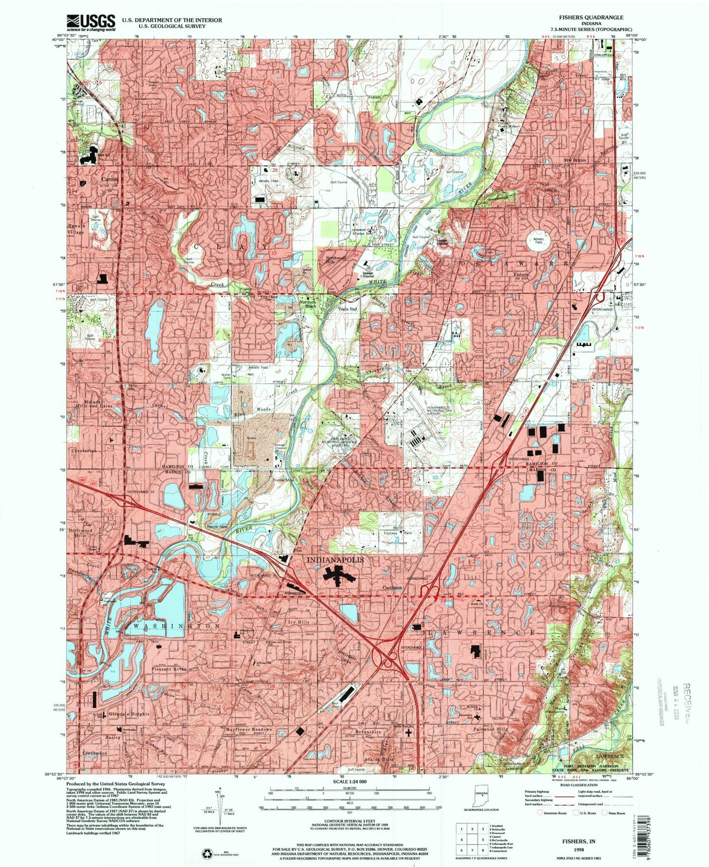
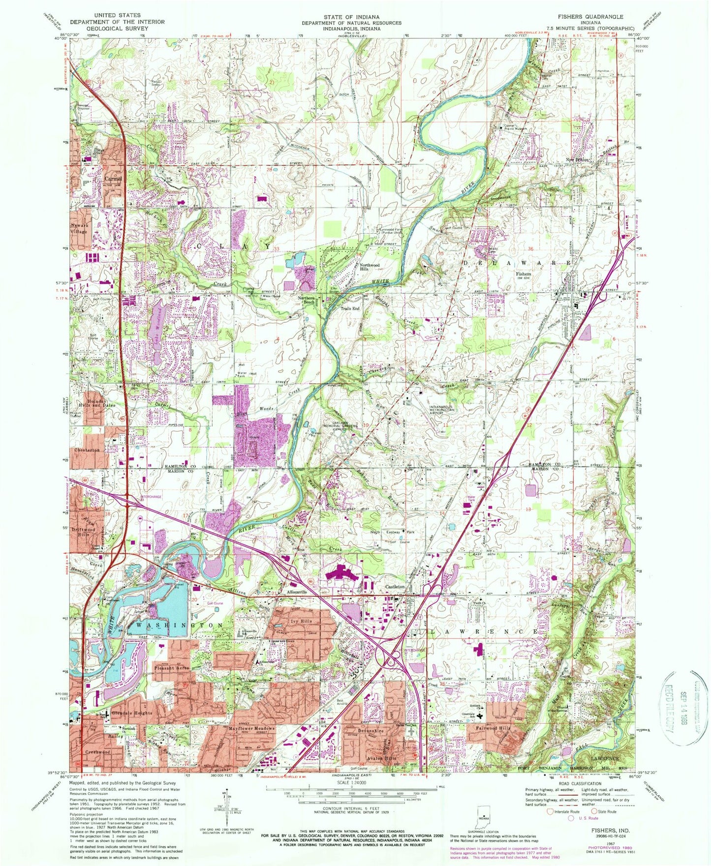
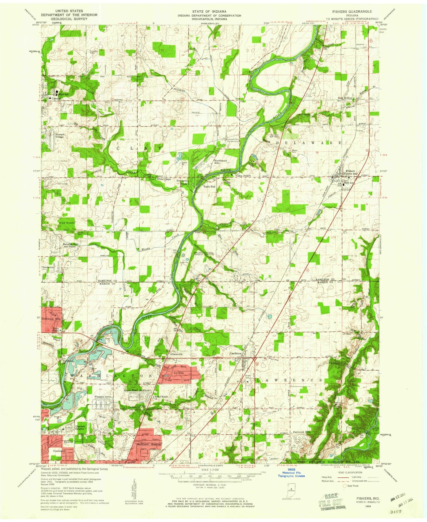
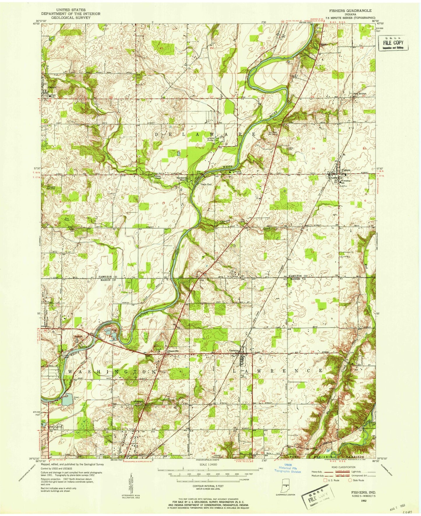
Classic USGS Fishers Indiana 7.5'x7.5' Topo Map
Couldn't load pickup availability
Historical USGS topographic quad map of Fishers in the state of Indiana. Typical map scale is 1:24,000, but may vary for certain years, if available. Print size: 24" x 27"
This quadrangle is in the following counties: Hamilton, Marion.
The map contains contour lines, roads, rivers, towns, and lakes. Printed on high-quality waterproof paper with UV fade-resistant inks, and shipped rolled.
Contains the following named places: Allison Run, Allisonville, Allisonville Christian Church, Allisonville Elementary School, Antioch Independent Christian Church, Avalon Hills, Behner Brook, Bishop Run, Blue Woods Creek, Britton Branch, Brook Ditch, Budd Run, Camp Branch, Carmel, Carmel Creek, Castle Creek, Castleton, Cheeney Creek, Chesterton, Episcopal Church of the Nativity, Conner Prairie Museum, Cool Creek, Creekwood, Crestview School, Cross and Crown Lutheran Church, Delight Creek, Devonshire, Driftwood Hills, Eller Bridge, Eller Run, Fairwood Hills, Faith Presbyterian Church, Farley Cemetery, Fishers, Glendale Heights, Haverstick Creek, Heady Cemetery, Heath Ditch, Hillsdale Run, Hiway Run, Holaday Hills and Dales, Home Run, Hot Lick Creek, Howe Creek, Howland Ditch, Indian Creek, Ivy Hills, Kirkendall Creek, Lantern Run, Light Branch, Little Cool Creek, Lynwood Farm Purdue University, Mark Run, Mayflower Meadows, Mitchner Ditch, New Britton, Newark Village, Nora Branch, North Eastway Park, Northeast Baptist Church, Northern Beach, Northside Baptist Church, Northwood Hills, Oaklawn Memorial Gardens Cemetery, Pleasant Acres, Ream Creek, Saint Pius X School, Sargent Brook, Sargs Run, Shoemaker Ditch, Skiles Test Elementary School, Smock Creek, Strange Creek, Trails End, Union Methodist Church, Vestal Ditch, Spannuth Cemetery, Weaver Creek, White Chapel Cemetery, Fishers Elementary School, Woodland Addition Lake, Woodland Addition Lake Dam, Saint Pius Roman Catholic Church, Lighthouse Tabernacle, Castleview Independent Baptist Church, Lux Lake Dam, Lux Lake, WHJE-FM (Carmel), Lake Woodland, Best Lock Airstrip (historical), Indianapolis Metropolitan Airport, Beaver Airstrip (historical), Keystone at the Crossing Shopping Center, Noregate Shopping Center, Castleton Square Shopping Center, Lakewood Villages Shoppes, Castleton Plaza, John Heath Ditch, Wadsworth Ditch (historical), Ivy Branch, Jose Creek, Vertland, Township of Delaware, Township of Lawrence, Church of the Nativity, Marion County Bridge 0501F, Hopewell Cemetery, Whitsell Cemetery, Lawrence Branch Indianapolis-Marion County Public Library, Carmel Lutheran Church, Chinese Community Church, Christ Community Church, First Baptist Church of Carmel, King of Glory Lutheran Church, New Hope Korean Baptist Church, Saint Elizabeth Seton Church, Saint Marks United Methodist Church, Hope Christian and Missionary Alliance Church, Fishers Heritage Park At White River, Ritchey Woods Nature Preserve, Loma Industrial Park, Crosspoint Business Park, Delaware Business Park, Centre North Shopping Center, North By Northeast Shopping Center, Signature Park Northeast Business Park, Exit 5 Business Park, Fishers Corners Commerce Park, Northeast Commerce Park, Roy G Holland Memorial Park, Fishers Pointe Shopping Center, Sunblest Commercial Park, Fishers Station Shopping Center, Sunblest Place Shopping Center, Fishers Landing Shopping Center, Fishers Crossing Shopping Center, Village At Main Street Shopping Center, Riverglen Golf Course, Prairie View Country Club, Cottingham Park, Harrison Park, New Britton Commercial Park, Fairlane Center Business Park, Fishers Trade Center, Britton Golf Course (historical), Parkside Business Park, Reynolds Industrial Park, New Britton Elementary School, Lantern Road Elementary School, Fishers Post Office, Fishers Town Hall, Fishers Fire Department Station 91 Headquarters, Hamilton East Public Library, Fishers Fire Department Station 93, Harrison Parkway Elementary School, Cherry Tree Elementary School, Prairie Trace Elementary School, Clay Middle School, Carmel-Clay Schools Central Administration Building, Carmel Fire Department Station 44, Mohawk Trails Elementary School, Carmel High School, Carmel Public Library, Carmel Elementary School, Carmel Post Office, Flowing Well Park, Carmel-Clay County Park, Woodbrook Elementary School, Forest Dale Elementary School, Carmel Fire Department Station 43, School Number 6 (historical), School Number 1 (historical), School Number 3 (historical), Nelson Office Park, White Oak Centre Shopping Center, Hazel Landing Park, Eller Road Park, Woodland Country Club, Merchant Square Shopping Center, Mohawk Hills Golf Course, Marsh Plaza Shopping Center, Brookshire Golf COurse, Founders Park, Oakhill Mansion, River Heritage Park, Plum Creek Golf Course, Mark Badger Park, River Road Park, Cedar Cove, Roxbury Pines, Hamilton Hills, Lantern Crossing, Lantern Pines, Covington Estates, Forest Ridge, Eller Commons, Eller Trails, Eller Run, White Horse Rapids, Round Up, Oxford Park, Princeton Park, Gatewood, Harvard Park, Wildwood Estates, Cherry Hill Farms, Bluestone, Northfield Estates, Berkley Ridge, Timber Springs, Hickory Woods, Burberry Place, Heritage Meadows, Morgan Meadows, Charleston Crossing, Maple Del, Conner Creek, Timber Lane Estates, River Edge, Barrington Ridge, River Glen, River Highlands, Sunblest Farms, Sunblest, Winding Creek, Fawnbrook Woods, New Britton Woods, Sweet Springs Estates, Lantern Farms, Lynwood Hills, Conner Knoll, Cottingham Estates, Harrison Woods, Harrison Park, Stevenson Mill, Connerwood