MyTopo
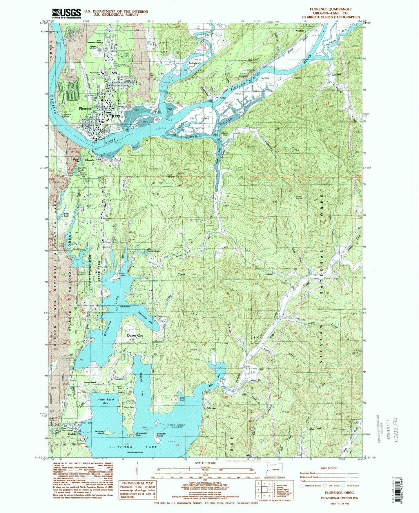
Classic USGS Florence Oregon 7.5'x7.5' Topo Map
Couldn't load pickup availability
Historical USGS topographic quad map of Florence in the state of Oregon. Map scale may vary for some years, but is generally around 1:24,000. Print size is approximately 24" x 27"
This quadrangle is in the following counties: Lane.
The map contains contour lines, roads, rivers, towns, and lakes. Printed on high-quality waterproof paper with UV fade-resistant inks, and shipped rolled.
Contains the following named places: Acme, Acme Post Office, Alderwood Water Development Company, Alene Post Office, Arrowhead Point, B and B Spur, Barrett Lake, Bay Bridge Marina, Bay Bridge Marina Boat Ramp, Bear Lake, Bernhardt Creek, Buck Creek, Bull Island, Butterfly Island, Camp Baker, Camp Cleawox, Camp Florence, Canary, Canary Post Office, Carle Creek, Carter Creek, City of Dunes City, City of Florence, Cleawox Lake, Coos Lower Umpqua and Siuslaw Reservation, Cougar Creek, Cox Creek, Cox Island, Cushman, Cushman Post Office, Cushman RV Park and Marina Boat Ramp, Darlings Resort Boat Ramp, Deer Creek, Demming Creek, Department of Motor Vehicles Florence, Drew Cemetery, Dunes City, Dunes City City Hall, Dunes City Division, Erhart Cove, Fishmill Lodges and RV Park Boat Ramp, Flint Creek, Florence, Florence City Dock and Ramp, Florence City Hall, Florence Events Center, Florence Foursquare Church, Florence Justice Center, Florence Municipal Airport, Florence Municipal Airport Terminal Building, Florence Playhouse, Florence Police Department, Florence Post Office, Florence Public Works Shop, Florence Wastewater Treatment Facility, Glenada, Glenada Ponds, Glenada Post Office, Grant Creek, Heceta Lodge Number 11 IOOF Cemetery, Honeyman State Park Boat Ramp, Jernigan Island, Jessie M Honeyman Memorial State Park, Joaquin Miller State Park, Johns Creek, Jordan Creek, Kiechle Arm, Lake Woahink Seaplane Base, Lane Community College, Lane County Public Works Shop Zone 5, Lilly Lake, Little North Woahink Lake, Maple Creek, Miller Arm, Miller Creek, Mills Creek, Mount Canary Company Log Pond, Munsel Creek, Munsel Creek County Park, Munsel Creek Water Treatment Plant, Neper, Nightingale's Fish Camp Boat Ramp, North Beach, North Beach Bay, North Fork Shoal, North Fork Siuslaw River, Ocean Dunes Golf Links, Ocean Dunes High School, Oregon Youth Authority Camp Florence Youth Transitional Facility, Pacific Sunset Memorial Park Cemetery, Peace Harbor Hospital, Pier Point Spring, Port of Siuslaw Marina Florence City Dock, Pritchard State Park, Prosser Slough, Rhododendron Elementary School, Roache Creek, Saint Marys Catholic Church, Saubert Creek, Schrum Creek, Shulte Creek, Siboco, Siltcoos, Siltcoos Lake, Siltcoos Lake Resort Boat Ramp, Siltcoos Post Office, Siuslaw Elementary School, Siuslaw High School, Siuslaw Marina, Siuslaw Marina Boat Ramp, Siuslaw Middle School, Siuslaw Pioneer Museum, Siuslaw Public Library Main Branch, Siuslaw School, Siuslaw Valley Fire and Rescue Station 1, Siuslaw Valley Fire and Rescue Station 2 Old Town Station, Siuslaw Valley Fire and Rescue Station 5 Canary Station, Siuslaw Valley Fire and Rescue Station 7 Oak Street Station, Siuslaw Valley Fire and Rescue Station 8 Clear Lake Station, Siuslaw Vista, Skunk Creek, Skunk Hollow, South Coast Water District, South Inlet, South Jetty Recreation Site, South Slough, Spruce Point, Spruce Point Cemetery, Stanwood, Summerbell Arm Woahink Lake, Tyee Campground Boat Ramp, Tyee Recreation Site, W D Hull Mill, Wendson, Wendson Canyon, West Woahink Lake Boat Ramp, Western Lane Ambulance District, Westlake, Westlake County Park, Westlake Post Office, Westlake Resort Boat Ramp, Woahink Creek, Woahink Lake, ZIP Code: 97493