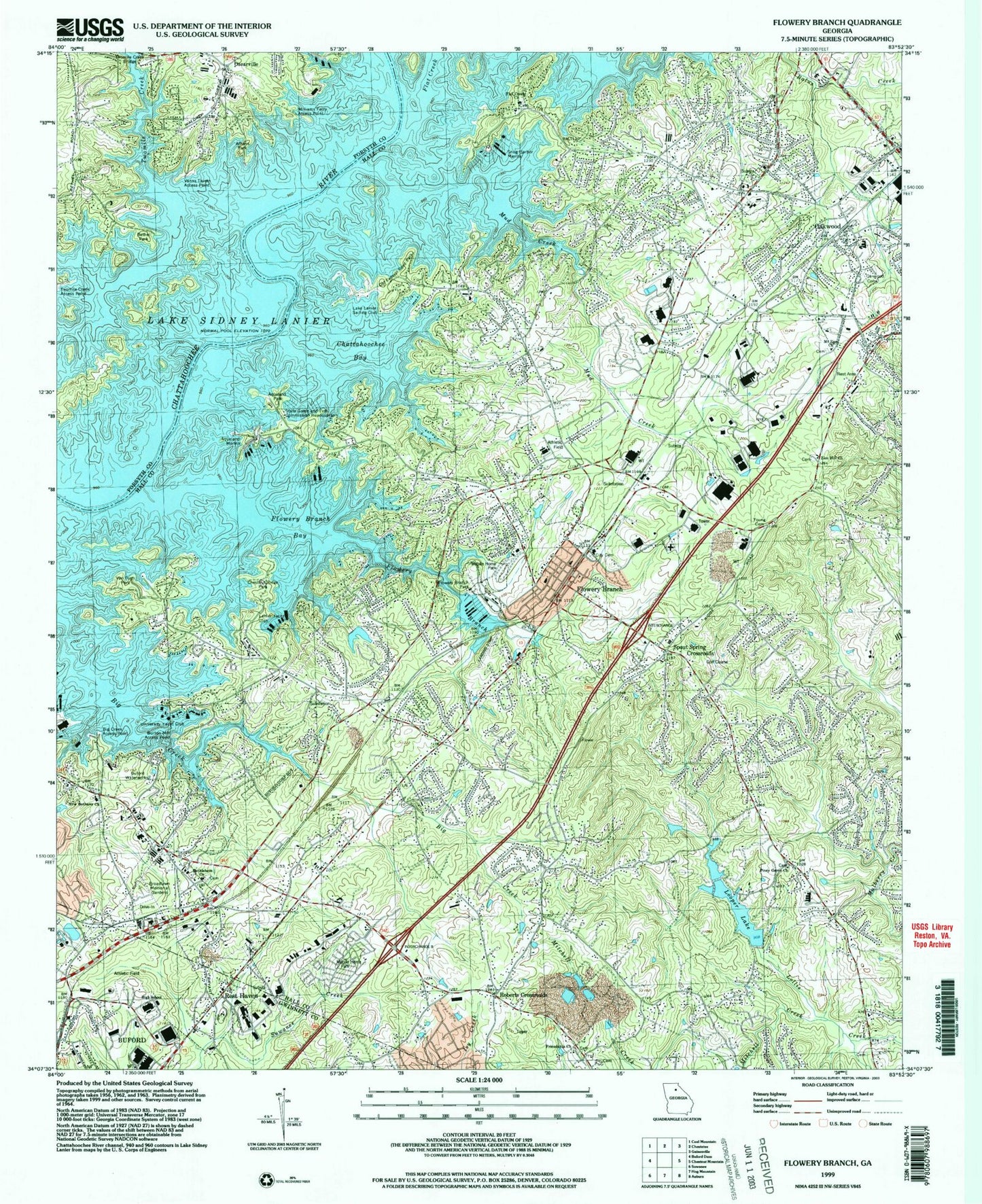
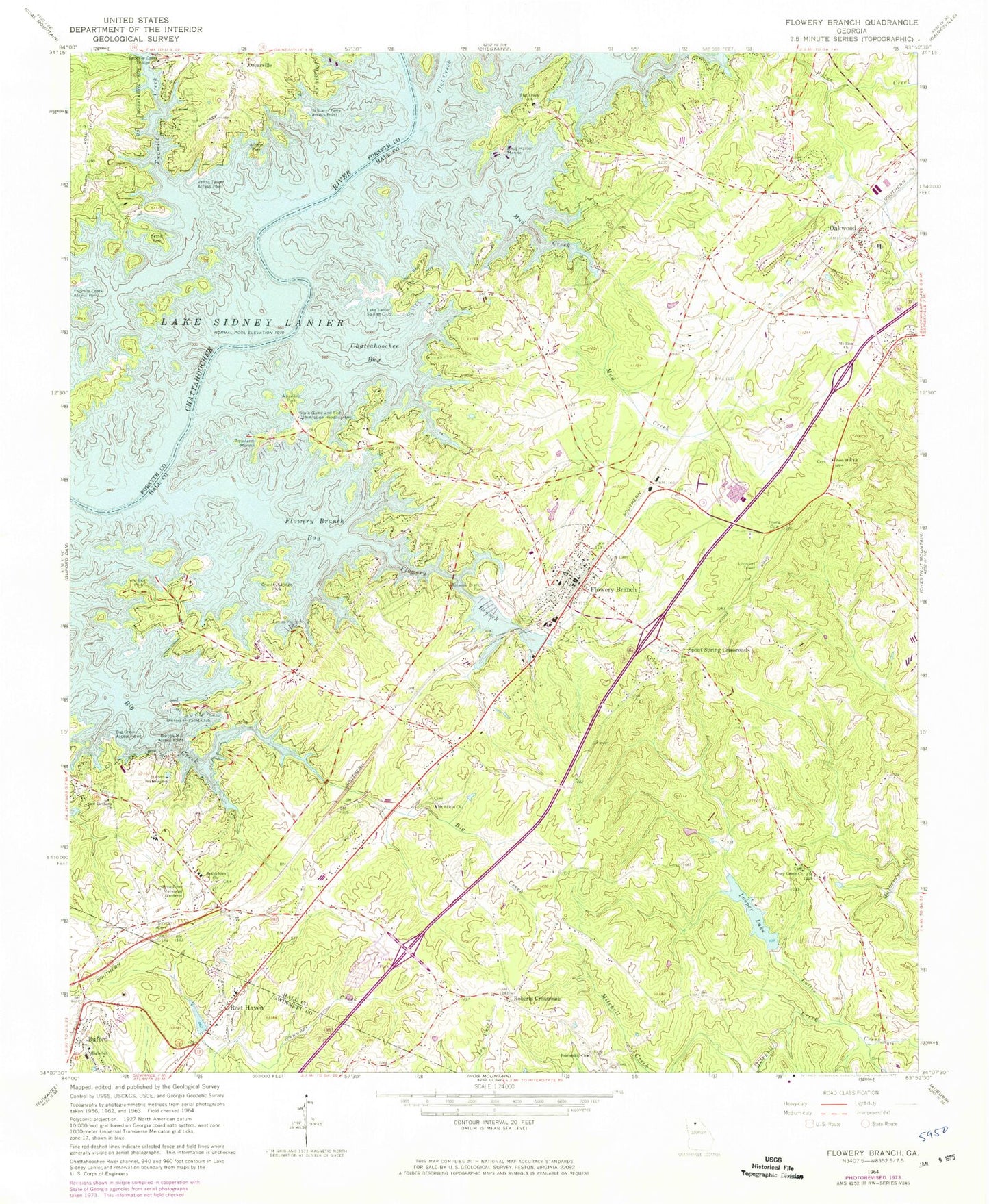
MyTopo
Classic USGS Flowery Branch Georgia 7.5'x7.5' Topo Map
Couldn't load pickup availability
Historical USGS topographic quad map of Flowery Branch in the state of Georgia. Map scale may vary for some years, but is generally around 1:24,000. Print size is approximately 24" x 27"
This quadrangle is in the following counties: Forsyth, Gwinnett, Hall.
The map contains contour lines, roads, rivers, towns, and lakes. Printed on high-quality waterproof paper with UV fade-resistant inks, and shipped rolled.
Contains the following named places: Alberta Banks Park, Aqualand Marina, Aqualand Park, Athens Park, Balus Creek, Beard, Bentwood, Bethel Park, Bethlehem Church, Big Creek, Big Creek Access Point, Bristol School, Broadlawn Memorial Gardens, Buford Academy, Buford Elementary School, Buford Fine Arts Center, Buford High School, Buford Middle School, Buford Waterworks, Burton Mill Access Point, Byers, C W Davis Middle School, Center School, Chattahoochee Baptist Cemetery, Chattahoochee Baptist Church, Chattahoochee Bay, Chestnut Ridge Park, Christ Lutheran Church of God, City of Flowery Branch, City of Oakwood, Commonwealth Industrial Park, Covenant Connections Church, Federal Crossing, First Baptist Church of Oakwood, Flat Creek, Flat Creek Baptist Cemetery, Flat Creek Church, Flowery Branch, Flowery Branch Bay, Flowery Branch Cemetery, Flowery Branch City Hall, Flowery Branch Commercial Historic District, Flowery Branch Division, Flowery Branch Elementary School, Flowery Branch High School, Flowery Branch Park, Flowery Branch Police Department, Flowery Branch Post Office, Flowery Branch School, Flowery Branch United Methodist Church, Forest Park, Fountain of Faith Church, Fox Hill, Free Methodist Tabernacle, Friendship Church, Friendship Elementary School, Gaines Ferry, Gay Lan, Goddards Ford, Green Crossing, Green Meadows, Hall County Fire Station 5, Hall County Fire Station 8, Hall Creek Village Business Park, Hammer, Hidden Harbor, Holiday Meadows, Holiday Villa, Holland, Jeffersonian School, Johnson, Lake Forest, Lake Lanier Sailing Club, Lanier Yacht Club, Lights Ferry, Loch Arbor, Looper Lake, Looper Lake Dam, Lott Creek, Manranatha Christian Academy Oakwood Extension, Maranatha Christian Academy, Martin Elementary School, McClure, McEver Road Baptist Church, Misty Cove, Mitchell Creek, Mount Calvery Church, Mount Salem Baptist Cemetery, Mount Salem Church, Mount Zion Cemetery, Mount Zion Church, Mud Creek, New Bethany Baptist Cemetery, New Bethany Church, Northeast Georgia Visitor Information Center, Oakwood, Oakwood Cemetery, Oakwood City Hall, Oakwood Division, Oakwood Elementary School, Oakwood Gospel Tabernacle, Oakwood Police Department, Oakwood Post Office, Old Federal Road Park, Olde Federal Pointe, Open Door Church, Oscarville, Peoples Church, Piney Grove Church, Piney Grove School, Pleasant View, Quail Run, Radford School, Raintree East, Raintree West, Reed, Rest Haven, Rest Haven City Hall, Roberts Crossroads, Sagefield, Sallee Heights, Scotts Cove, Smith Cemetery, Snug Harbor Marina, Southgate, Spout Spring Crossroads, Spout Springs Elementary School, Sprout Springs Elementary School, The Flying W Ranch Airport, The Rock Church Flowery Branch, Town of Rest Haven, Trudy Estates, Twomile Creek, Twomile Creek Bridge, University Yacht Club, Van Pugh Park, Vanns Tavern Access Point, Vista Brook, Waverly Way, Wayne, West Hall Baptist Church, West Hall High School, West Hall Middle School, Wheeler Cemetery, Williams Ferry Access Point, Winns Ferry, Woodbridge, Woodlake, Young Family Cemetery, Zion Hill Baptist Cemetery, Zion Hill Church, ZIP Codes: 30542, 30566