MyTopo
Classic USGS Flushing New York 7.5'x7.5' Topo Map
Couldn't load pickup availability
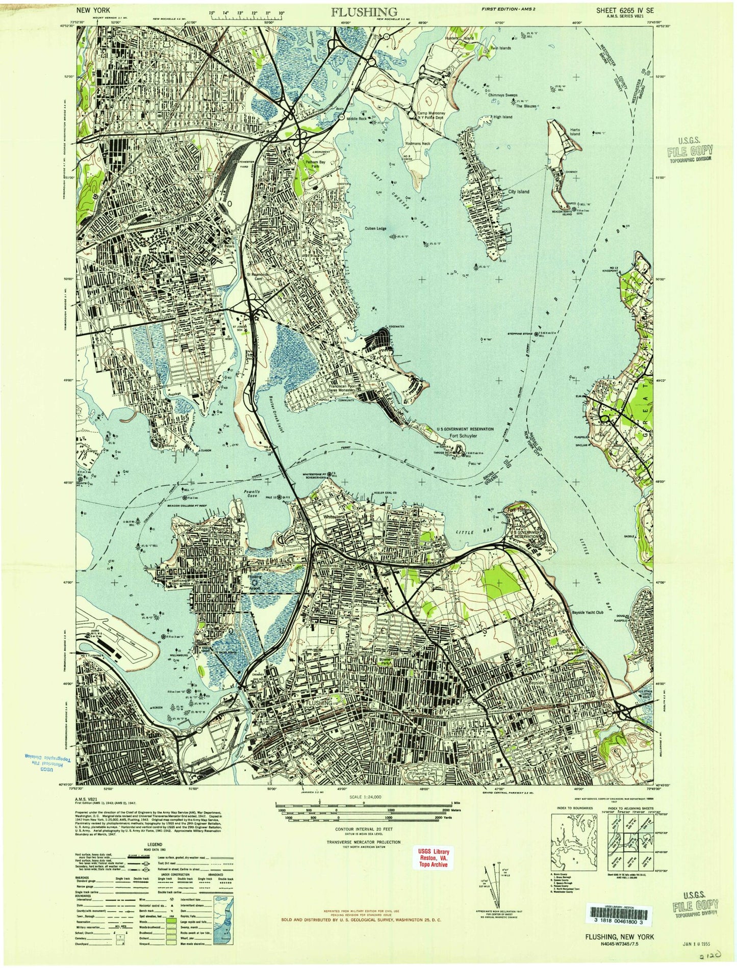
Historical USGS topographic quad map of Flushing in the state of New York. Typical map scale is 1:24,000, but may vary for certain years, if available. Print size: 24" x 27"
This quadrangle is in the following counties: Bronx, Nassau, Queens, Westchester.
The map contains contour lines, roads, rivers, towns, and lakes. Printed on high-quality waterproof paper with UV fade-resistant inks, and shipped rolled.
Contains the following named places: Alley Creek, Auburndale Station, Bartow-Pell Mansion Museum, Baychester, Bayside, Bayside Station, Beechhurst, Belden Point, Beth Abraham Home for the Incurables, Big Tom, Blessed Sacrament School (historical), Blessed Sacrament School, Bowne House, Bowne Park, Broadway Station, Bronx River, Bronx Psychiatric Center, Bronxdale, Benjamin Cardozo High School, Castle Hill Point, Cherry Tree Point, Chimney Sweeps Islands, Christopher Columbus High School, City Island, City Island Bridge, City Island Harbor, Clason Point, Public School 100, College Point, College Point, College Point Reef, Hermon A MacNeil Park, Crocheron Park, Cryders Point, Cuban Ledge, Deep Reef, East Elmhurst, East Nonations, Eastchester Bay, Albert Einstein College of Medicine of Yeshiva University, Intermediate School 131, Elm Point, Ferry Point Park, Flushing, Flushing Bay, Flushing Cemetery, Flushing Creek, Flushing High School, Flushing Hospital Medical Center, Public School 184, Flushing Station, Francis Lewis Park, Givan Creek, John Golden Park, Goose Island, Green Flats, Haffen Park, Hammond Creek, Hart Island, Intermediate School 125, Museum of the American Indian Heye Foundation Annex (historical), High Island, Holy Cross High School, Holy Cross School, Holy Rosary School, Hunts Point, Hutchinson River, Institute for Education of the Blind, Middle School X101 Edward R Byrne, Junior High School X123 James M Kiernan, Middle School 127, Middle School 135, Middle School 158, Junior High School 185, Junior High School 189, Junior High School 194, Kennedy Childrens Home, Public School 193, Leavitts Park, Little Bay, Little Neck Bay, Locust Point, Locust Point, Machaux Rock, Malba, Martin Field, Memorial Field of Flushing, Middle Reef, Middle Rock, Mill Creek, Morris Park, Murray Hill Station, Oakland Gardens, Oakland Lake, Old Ferry Point, Orchard Beach, Our Lady of Sorrows School, Park of Edgewater, Parkchester, Parkway School, Parsons Beach, Parsons Hospital (historical), Pelham Bay, Pelham Bay Park, Pelham Bridge, Pelham Cemetery, Public School 92, Monastery of Saint Clare, Potters Field Burial Ground, Powell Cove, Preston High School, Public School 102, Public School 105, Public School 107, Public School 107, Public School 108, Public School 119, Public School 119, Public School 121, Public School 127, Public School 129, Public School 130, Public School 138, Public School 14, Public School 143, Public School 149, Public School 159, Public School 169, Public School 17 (historical), Public School 20, Public School 209, Public School 21, Public School 214, Public School 22, Public School 23, Public School 24, Public School 27 (historical), Public School 29, Public School 31, Public School 32, Public School 41, Public School 41, Public School 47, Public School 615, Public School 69, Public School 71, Public School 72, Public School 79, Public School 83, Public School 89, Public School 96, Public School 97, Pugsley Creek, Queensborough Community College - City University of New York, Rat Island, Raymond O'Conner Park, Rodman Neck, Sacred Hearts School, Saint Agnes Academy High School, Saint Andrew Avellino School, Saint Anthony School, Saint Benedict School, Saint Catherine Academy, Saint Clare School, Saint Dominic Roman Catholic Parochial School, Saint Fidelis School, Saint Francis Xavier Parochial School, Saint Gabriels School, Saint Josephs School, Monsignor Scanlan High School, Saint Kevin School, Saint Lucy School, Saint Lukes School, Saint Mary's Hospital for Children, Saint Marys School, Saint Marys Star of the Sea School, Saint Mel's School, Saint Michael School, Saint Peter's Episcopal Church, Saint Raymond Cemetery, Saint Raymonds School, Sound View Park, South Nonations, Stepping Stones, Stepping Stones Light, Stepping Stones Park, Tallman Island, The Bluzes, Throgs Neck, Throgs Neck Bridge, Throgs Point, Trinity School, Turtle Cove, Twin Island, Unionport, United States Merchant Marine Academy, Van Nest, Van Nest Yard, Villa Maria Academy, Village Park, Little Neck, Westchester, Westchester Creek, Whitestone, Whitestone Bridge, Whitestone Point, Bronx, WNBC and WCBS, Weir Creek, Bird Grove, Cape Ruth, State University of New York Maritime College, LaGuardia Airport, Bronx County, Clason Point, Hewlett Point, Throgs Neck, Willets Point, Rice Memorial Stadium, Shea Stadium (historical), Edo Seaplane Base, Traulsen-College Point Heliport, Flushing Airport (historical), Landmark Plaza Heliport, Evers Seaplane Base, WFAN-AM (New York), WCBS-AM (New York), Borough of Bronx, Bronx Children's Psychiatric Center, Battery Beecher (historical), Battery Bell (historical), Battery Gansevoort (historical), Battery Hazzard (historical), Fort Schuyler (historical), Battery Baker (historical), Battery Burnes (historical)