

MyTopo
Classic USGS Fort Barrancas Florida 7.5'x7.5' Topo Map
Couldn't load pickup availability
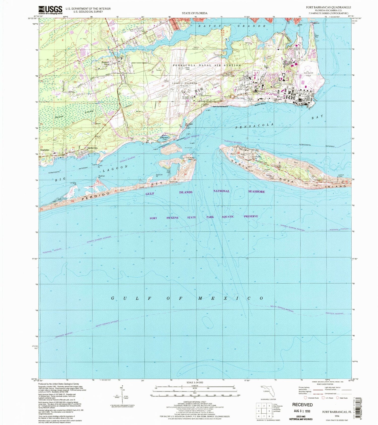
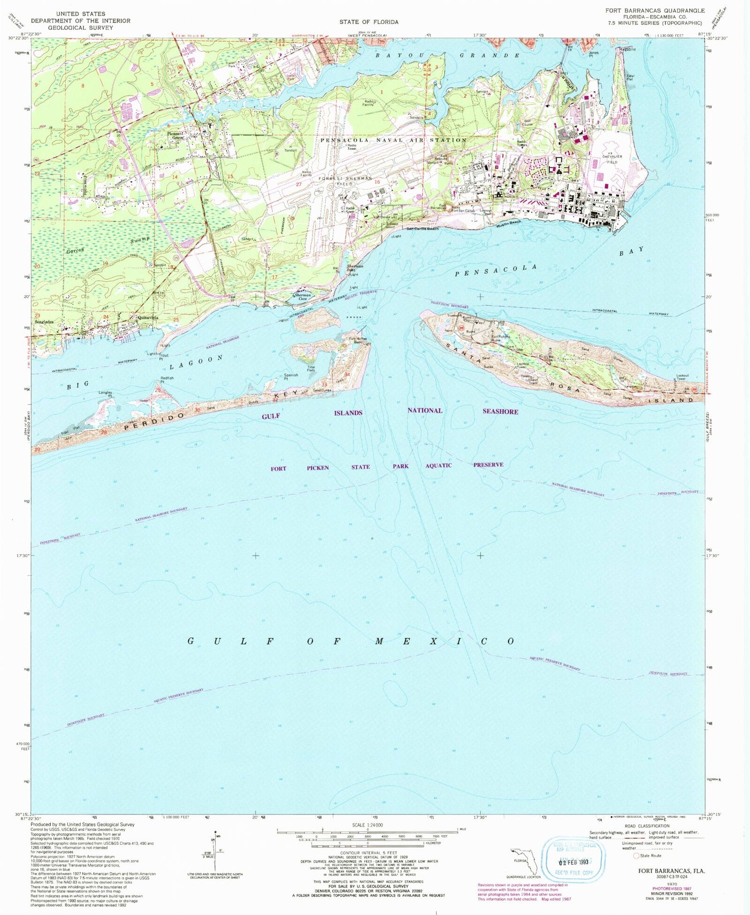
Historical USGS topographic quad map of Fort Barrancas in the state of Florida. Typical map scale is 1:24,000, but may vary for certain years, if available. Print size: 24" x 27"
This quadrangle is in the following counties: Escambia.
The map contains contour lines, roads, rivers, towns, and lakes. Printed on high-quality waterproof paper with UV fade-resistant inks, and shipped rolled.
Contains the following named places: Barrancas National Cemetery, Bayou Grande, Fort Pickens Ruins (historical), Fort Pickens State Park, Jones Point, Langley Point, Magazine Point, Mustin Beach, Pleasant Grove, Quinavista, Redfish Point, San Carlos Beach, Sherman Cove, Sherman Inlet, Spanish Point, Trout Point, Caucus Shoal, Fort Pickens, Big Lagoon, Middle Ground, Fort Barrancas (historical), Fort McRee (historical), Fort Redoubt (historical), Fort San Carlos (historical), Fort McRee Leading Light, Pleasant Grove Elementary School, Redoubt Bayou, Robertson Island, Red Bluffs, Chasefield Plantation Cemetery, Sherman Grove, House Memorial African Methodist Episcopal Zion Church, Joaquin Barella Grant, Francisco Barrios Grant, Fort Pickens State Park Aquatic Preserve, Fort Barrancas Barracks, Pensacola Lighthouse, National Museum of Naval Aviation, Escambia Bay Marine Institute, Chevalier Field (historical), Battery Langdon (historical), Battery Worth (historical), Battery Pensacola (historical), Battery Cullum (historical), Battery Sevier (historical), Battery Van Swearingen (historical), Battery Payne (historical), Battery Trueman (historical), Battery Cooper (historical), Battery Slemmer (historical), Battery Center (historical), Naval Air Station Pensacola, Escambia County Fire and Rescue Station 14 Pleasant Grove, Naval Air Station Regional Fire and Emergency Services Station 5, Naval Air Station Regional Fire and Emergency Services Station 4, Naval Air Station Regional Fire and Emergency Services Station 3, Naval Air Station Regional Fire and Emergency Services Station 2, Naval Air Station Regional Fire and Emergency Services Station 1, Pensacola Naval Air Station/Forrest Sherman Field, Naval Air Station Post Office, Pensacola Station Census Designated Place, Barrancas National Cemetery, Bayou Grande, Fort Pickens Ruins (historical), Fort Pickens State Park, Jones Point, Langley Point, Magazine Point, Mustin Beach, Pleasant Grove, Quinavista, Redfish Point, San Carlos Beach, Sherman Cove, Sherman Inlet, Spanish Point, Trout Point, Caucus Shoal, Fort Pickens, Big Lagoon, Middle Ground, Fort Barrancas (historical), Fort McRee (historical), Fort Redoubt (historical), Fort San Carlos (historical), Fort McRee Leading Light, Pleasant Grove Elementary School, Redoubt Bayou, Robertson Island, Red Bluffs, Chasefield Plantation Cemetery, Sherman Grove, House Memorial African Methodist Episcopal Zion Church, Joaquin Barella Grant, Francisco Barrios Grant, Fort Pickens State Park Aquatic Preserve, Fort Barrancas Barracks, Pensacola Lighthouse, National Museum of Naval Aviation, Escambia Bay Marine Institute, Chevalier Field (historical), Battery Langdon (historical), Battery Worth (historical), Battery Pensacola (historical), Battery Cullum (historical), Battery Sevier (historical), Battery Van Swearingen (historical), Battery Payne (historical), Battery Trueman (historical), Battery Cooper (historical), Battery Slemmer (historical), Battery Center (historical), Naval Air Station Pensacola, Escambia County Fire and Rescue Station 14 Pleasant Grove, Naval Air Station Regional Fire and Emergency Services Station 5, Naval Air Station Regional Fire and Emergency Services Station 4, Naval Air Station Regional Fire and Emergency Services Station 3, Naval Air Station Regional Fire and Emergency Services Station 2, Naval Air Station Regional Fire and Emergency Services Station 1, Pensacola Naval Air Station/Forrest Sherman Field, Naval Air Station Post Office, Pensacola Station Census Designated Place


