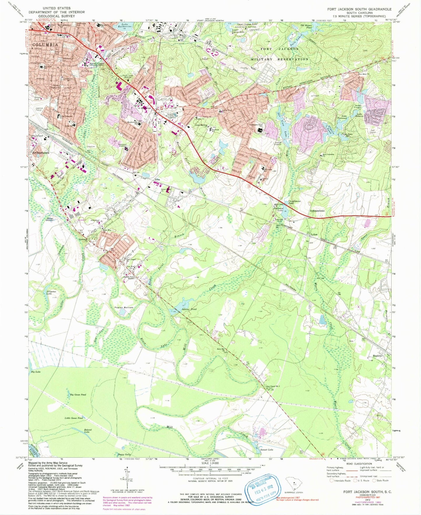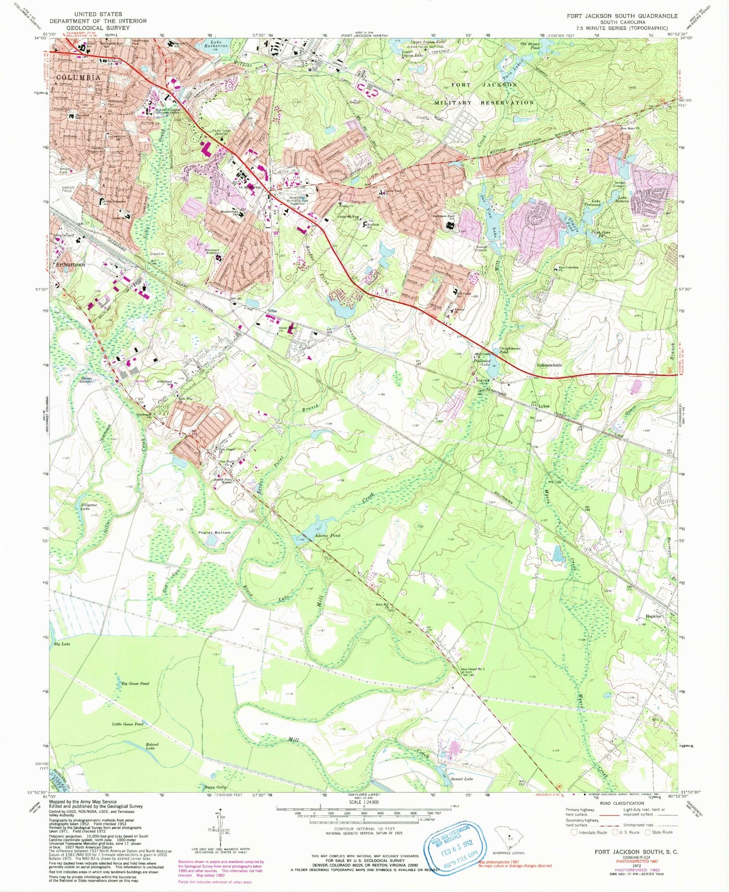
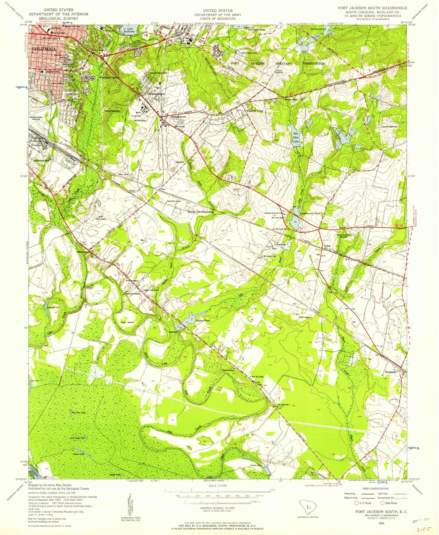
MyTopo
Classic USGS Fort Jackson South South Carolina 7.5'x7.5' Topo Map
Couldn't load pickup availability
Historical USGS topographic quad map of Fort Jackson South in the state of South Carolina. Map scale may vary for some years, but is generally around 1:24,000. Print size is approximately 24" x 27"
This quadrangle is in the following counties: Calhoun, Richland.
The map contains contour lines, roads, rivers, towns, and lakes. Printed on high-quality waterproof paper with UV fade-resistant inks, and shipped rolled.
Contains the following named places: Adams Pond, Alligator Lake, Arthur Davis Church, Atlas Road School, Bates Park, Bates School, Bendemeer, Berkeley Forest, Bethlehem Church, Bible Way Church, Big Goose Pond, Black Lake, Bluff Estates, Bluff Road Park, Brandon Acres, Brandon Hills, Brennen School, Burnside East, Burnside School, Burnsides Pond D-0576 Dam, Capitol View, Capitol View Census Designated Place, Capitol View Church, Captain Jims Pond, Caughman Road Park, Caughmans Pond, Caughmans Road School, Cedar Terrace Shopping Center, Charlestowne, Childs, Childs Cemetery, Christ the King Church, Columbia - Richland Fire Department Industrial Park, Columbia - Richland Fire Service Capitol View, Columbia - Richland Fire Station Atlas Road, Columbia Industrial Park, Cow Cut, Dominion Hills, Dorn VA Medical Center Police Department, Dreher High School, East Columbia Church, Eastmont, Eastway Park, Fort Jackson Fire Department, Galaxy, Gallman School, Goose Branch, Gordon Springs, Green Lawn Memorial Park, Greenlawn Church, Hammond Academy, Hampton Memorial Park, Hampton Ridge, Hampton Trace, Hazelwood Acres, Heathwood, Heathwood Hall School, Heathwood Park, Heritage Woods, Hopkins, Independents, Jim Hamilton L B Owens Airport, Knollwood, Lake Katherine, Lake Rebecca, Lake Trotwood, Lake Trotwood Dam, Landmark Square Shopping Center, Lee Hills, Little Calvary Church, Little Goose Pond, Lower Legion Lake, Lower Twin Lake, Lower Twin Lake Dam - Fort Jackson, Lykes, Lykesland School, Meadowfield, Meadowfield School, Midland Technical Education Center, Mill Creek Church, Mill Creek Estates, Mill Creek School, Millwood, Mount Calvary Church, Mountain Brook, New Hope Church, New Veile Church, New Viele Chapel, Old Heises Pond, Padgett Acres, Pennington Acres, Pine Bluff Church, Pine Lake, Pinewood Lake, Pinewood Lake D-0580 Dam, Poplar Bottom, Quail Creek, Quail Hills, Reeder Point Branch, Reeder Point Mission, Reedy Point School, Rock Hill Church, Rock Hill School, Roland Lake, Rosewood, Rosewood Park, Rosewood School, Rosewood Shopping Center, Saint Marks Wood, Sims, Sims Park, South Carolina Noname 40012 D-0577 Dam, South Kilbourne School, Starlite, Strathaven Forest, Sun View Lake, Sunset Fishing Club, Sunset Lake, Sweet Home Church, Temple Church, Trinity Church, Twin Lakes, Ulmers Pond, Ulmers Pond D-0581 Dam, Upper Legion Lake, Upper Legion Lake Dam - Fort Jackson, Valencia Heights, Valencia Playground, Veals Chapel, Veals School, Village Bond, Washington Lake, Washington Park, Wildcat Creek, William Jennings Bryan Dorn Veterans Affairs Medical Center, Woodhill Estates, Woodhill Mall Shopping Center, Woodland Park, Yorkshire, Zion Chapel Church, Zion Chapel Number 2, ZIP Codes: 29205, 29209