MyTopo
Classic USGS Fort Knox Kentucky 7.5'x7.5' Topo Map
Couldn't load pickup availability
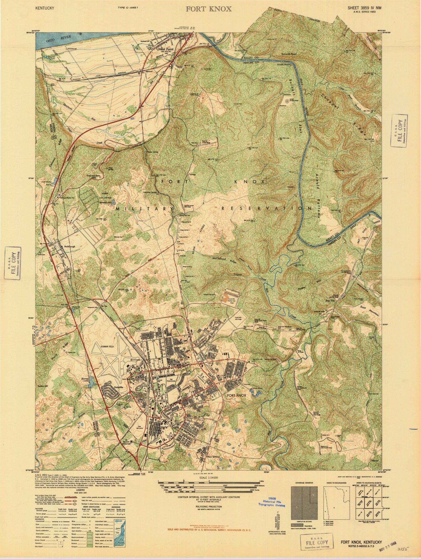
Historical USGS topographic quad map of Fort Knox in the state of Kentucky. Typical map scale is 1:24,000, but may vary for certain years, if available. Print size: 24" x 27"
This quadrangle is in the following counties: Bullitt, Hardin, Harrison, Jefferson, Meade.
The map contains contour lines, roads, rivers, towns, and lakes. Printed on high-quality waterproof paper with UV fade-resistant inks, and shipped rolled.
Contains the following named places: Arnold Bottoms, Arnold Rocks, Boone Cemetery, Briscoe School, Burcham Cemetery, Burnett Flat, Buzzard Roost, Calvin Cemetery Number 1, Cameron Ridge, Canby Hill, Cedar Grove Cemetery, Cedar Point Branch, Chappel Ridge, Cornwell Field, Crittenberger School, Davis Cemetery, Dickerson Lake, Dripping Springs, Dry Branch, Easy Gap, Field Cemetery, Fort Hill Cemetery, Gaffey Heights, Gander Branch, Gentry Cemetery, Geoghegan Cemetery, Godman Chapel, Hart Cemetery, High School, Hilltop Chapel, Hooker Mountain, Ireland Army Community Hospital, Johnson Branch, Johnson Cemetery, Kingsolver School, Long Cemetery, March Ridge, McClelland Ridge, McCormick Cemetery, McIntire Cemetery, Mill Creek, Montgomery Cemetery, Muldraugh, Muth Cemetery, Phillips Cemetery, Pierce School, Pleasant View Cemetery East, Pond Creek, Poplar Spring, Prewitts Lake, Prichard Chapel, Prichard Place, Ray Cemetery, Rose Terrace, Round Hollow, Fort Knox Post Cemetery, Scott Junior High School, Scott Mountain, Stevens School, The Armor Center, Thorne Park, Tioga Creek, Tioga Spring, Tip Top, Tip Top Station, Tobacco Leaf Lake, Tollgate Creek, Turret Field, Van Voorhis Manor, West Point, Withers Cemetery, Howard, Davis Cemetery, Sutherland Cemetery, Bleakley Cemetery, Eisenhower Chapel, MacDonald Junior High School, Mudge School, VanVoorhis School, Heard Park, Fort Hill City Park, Anderson Golf Course, Golf Course, United States Bullion Depository, Godman Army Airfield, West Point Division, Fort Knox Census Designated Place, City of Muldraugh, City of West Point, Muldraugh Post Office, West Point Post Office, Fort Knox, Fort Knox Division, Muldraugh Fire Department, Fort Knox Fire Division Station 1, Crystal Lake, Muir Hill, North Fork Dry Branch, HRCoe Post Office, Fort Knox Post Office, Arnold Bottoms, Arnold Rocks, Boone Cemetery, Briscoe School, Burcham Cemetery, Burnett Flat, Buzzard Roost, Calvin Cemetery Number 1, Cameron Ridge, Canby Hill, Cedar Grove Cemetery, Cedar Point Branch, Chappel Ridge, Cornwell Field, Crittenberger School, Davis Cemetery, Dickerson Lake, Dripping Springs, Dry Branch, Easy Gap, Field Cemetery, Fort Hill Cemetery, Gaffey Heights, Gander Branch, Gentry Cemetery, Geoghegan Cemetery, Godman Chapel, Hart Cemetery, High School, Hilltop Chapel, Hooker Mountain, Ireland Army Community Hospital, Johnson Branch, Johnson Cemetery, Kingsolver School, Long Cemetery, March Ridge, McClelland Ridge, McCormick Cemetery, McIntire Cemetery, Mill Creek, Montgomery Cemetery, Muldraugh, Muth Cemetery, Phillips Cemetery, Pierce School, Pleasant View Cemetery East, Pond Creek, Poplar Spring, Prewitts Lake, Prichard Chapel, Prichard Place, Ray Cemetery, Rose Terrace, Round Hollow, Fort Knox Post Cemetery, Scott Junior High School, Scott Mountain, Stevens School, The Armor Center, Thorne Park, Tioga Creek, Tioga Spring, Tip Top, Tip Top Station, Tobacco Leaf Lake, Tollgate Creek, Turret Field, Van Voorhis Manor, West Point, Withers Cemetery, Howard, Davis Cemetery, Sutherland Cemetery, Bleakley Cemetery, Eisenhower Chapel, MacDonald Junior High School, Mudge School, VanVoorhis School, Heard Park, Fort Hill City Park, Anderson Golf Course, Golf Course, United States Bullion Depository, Godman Army Airfield, West Point Division, Fort Knox Census Designated Place, City of Muldraugh, City of West Point, Muldraugh Post Office, West Point Post Office, Fort Knox, Fort Knox Division, Muldraugh Fire Department, Fort Knox Fire Division Station 1, Crystal Lake, Muir Hill, North Fork Dry Branch, HRCoe Post Office, Fort Knox Post Office, Arnold Bottoms, Arnold Rocks, Boone Cemetery, Briscoe School, Burcham Cemetery, Burnett Flat, Buzzard Roost, Calvin Cemetery Number 1, Cameron Ridge, Canby Hill, Cedar Grove Cemetery, Cedar Point Branch, Chappel Ridge, Cornwell Field, Crittenberger School, Davis Cemetery, Dickerson Lake, Dripping Springs, Dry Branch, Easy Gap, Field Cemetery, Fort Hill Cemetery, Gaffey Heights, Gander Branch, Gentry Cemetery, Geoghegan Cemetery, Godman Chapel, Hart Cemetery, High School, Hilltop Chapel, Hooker Mountain, Ireland Army Community Hospital, Johnson Branch, Johnson Cemetery, Kingsolver School, Long Cemetery