MyTopo
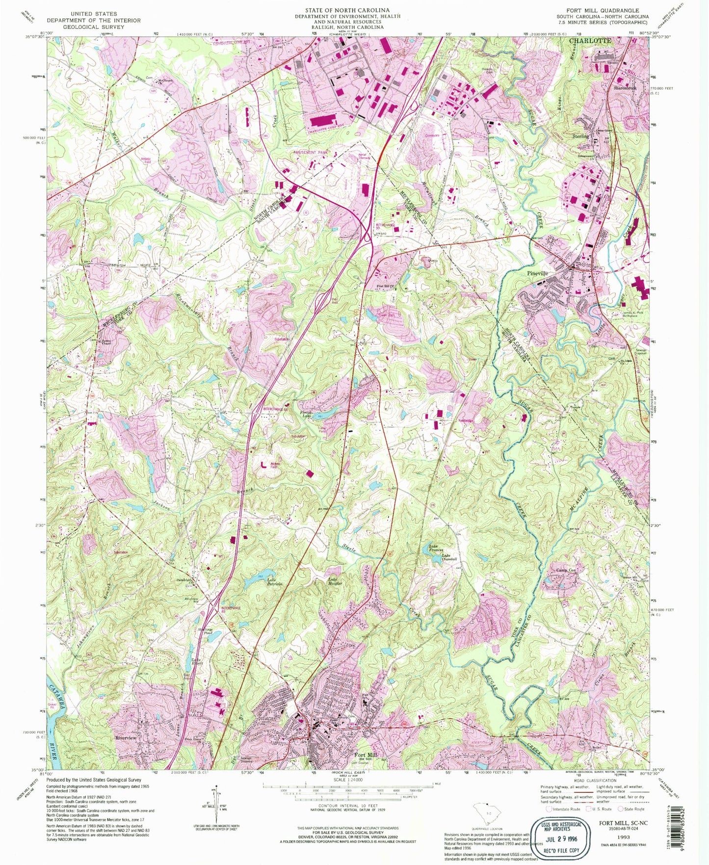
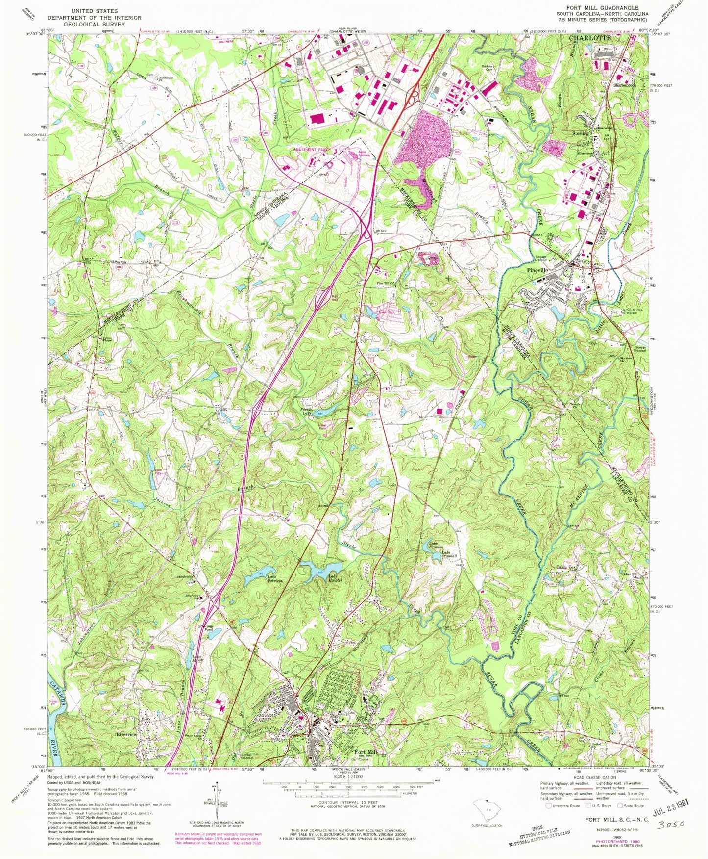
Classic USGS Fort Mill South Carolina 7.5'x7.5' Topo Map
Couldn't load pickup availability
Historical USGS topographic quad map of Fort Mill in the states of South Carolina, North Carolina. Typical map scale is 1:24,000, but may vary for certain years, if available. Print size: 24" x 27"
This quadrangle is in the following counties: Lancaster, Mecklenburg, York.
The map contains contour lines, roads, rivers, towns, and lakes. Printed on high-quality waterproof paper with UV fade-resistant inks, and shipped rolled.
Contains the following named places: Bethel Church, Lake Crandall, Lake Elliott, Forest Lake, Lake Frances, Lake Haigler, Jackson Branch, James Chapel, Johnnytown Branch, Jones School, Lake Patricia, Philadelphia Church, Piney Grove Church, Riverview, Stallings Pond, Camp Cox, Carowinds, Carowood, Flint Hill School (historical), Forest Lake, Fort Mill Country Club, Fort Mill Elementary School, Fort Mill High School, Fort Mill Primary School, Fort Mill Public Library, Fort Mill Square Shopping Center, Grey Rock, Grey Rock Golf Course, Kanawha Hills, Macedonia Church, Old Orchid, River View School (historical), Saint James Church (historical), Saint James School (historical), Whiteville Park, Gold Hill School (historical), Oak Grove Church (historical), Riverview Chapel, South Carolina Noname 46015 D-3480 Dam, South Carolina Noname 46016 D-1238 Dam, Lake Haigler, South Carolina Noname 46032 D-3645 Dam, Heritage Lake Dam D-3648, Heritage Lake, Lake Frances Dam D-3647, Lake Crandall Dam D-3646, Creech Pond Dam D-1236, Creech Pond, Lake Elliot Dam D-1234, Stalling Pond Dam D-1233, Gibson Pond Dam D-3644, Gibson Pond, Barberville, Barberville School (historical), Harrisburgh Mill (historical), Indian Hill Church, Fish School, Flint Hill Baptist Church, Fort Mill, Riverview School, Fort Mill Division, Riverview Census Designated Place, Town of Fort Mill, Riverview Fire Department, Flint Hill Fire Department Station 1, Flint Hill Fire Department Station 2, Fort Mill Fire Department, Fort Mill Emergency Medical Services Tega Cay Rescue Squad, James Chapel Cemetery, Baxter Village Census Designated Place, Blankmanship Branch, China Grove Church, Dinkins Cemetery, James K Polk Birthplace, Kings Branch, Little Sugar Creek, McAlpine Creek, McClintock Church, McCullough Branch, Polk Ditch, Saint Johns Church, Silvermount Church, Steele Creek, Temple Church, Walker Branch, Carowinds Airport (historical), Flying H Farm Airport (historical), Crystal Springs Lake Dam, Crystal Springs Lake, Number One Settling Basin, Arrowood Southern, Banalsburg (historical), Carowinds, Commerce Industrial Park, Eden Gardens, Morrows (historical), Park Place Shopping Center, Pineville Elementary School, Pineville Town Center Shopping Center, Ravenwood, Southland Industrial Park, Sterling Elementary School, Central Steele Creek Community House (historical), Outlet Marketplace, Pineville, Sharonbrook, Sterling, Steele Creek Elementary School (historical), Township 14-Pineville, Lake Wylie Elementary School, Public Library of Charlotte and Mecklenburg County - Steele Creek Branch, Southwest Middle School, Town of Pineville, Pineville Quarry, Steele Creek Athletic Association Park, Steele Creek Masonic Lodge 737 AF & AM, Steele Creek Volunteer Fire Department Station 2 / Rescue Ambulance, Pineville - Morrow Volunteer Fire Department, Pineville Police Department, Pineville Post Office, McClintock Church Cemetery, Lawrence Chapel Presbyterian Church Cemetery, Saint Johns Church Cemetery