MyTopo
Classic USGS Fort Moultrie South Carolina 7.5'x7.5' Topo Map
Couldn't load pickup availability
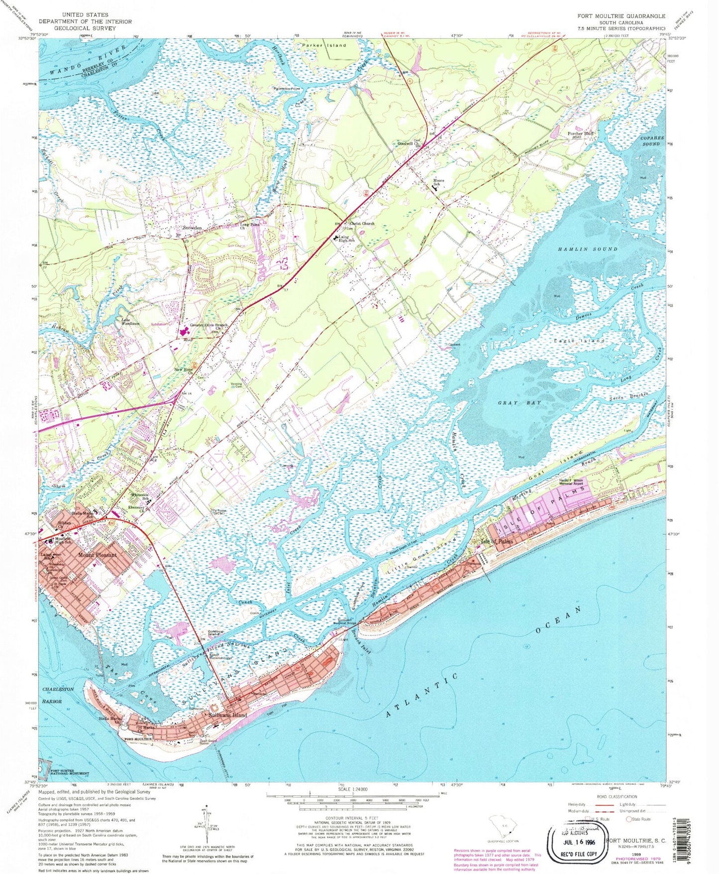
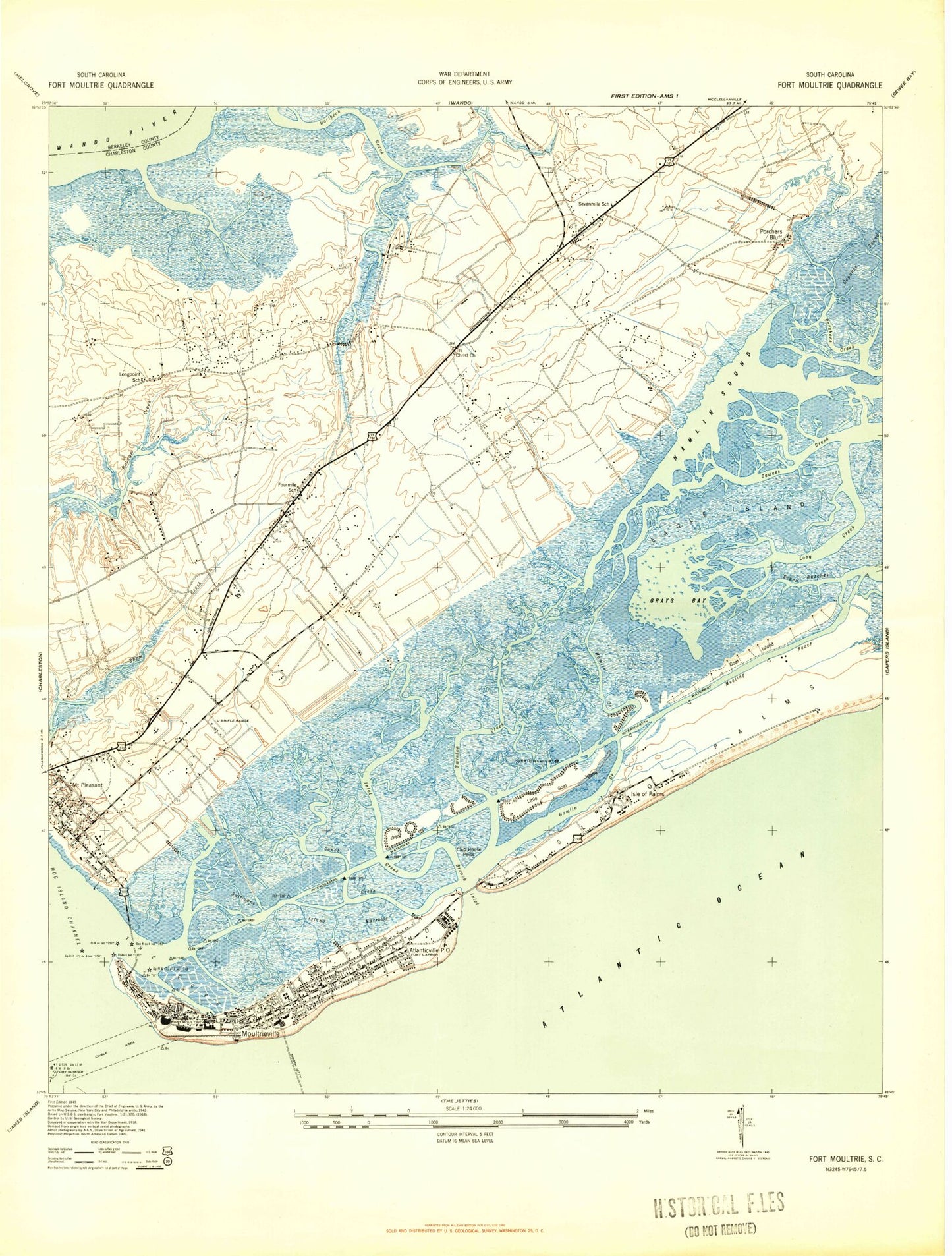
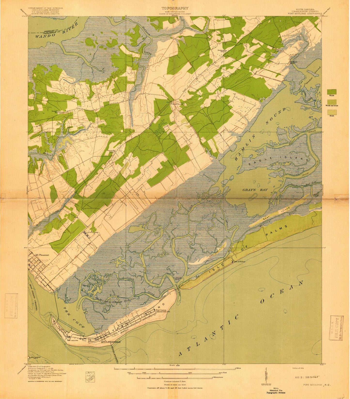
Historical USGS topographic quad map of Fort Moultrie in the state of South Carolina. Typical map scale is 1:24,000, but may vary for certain years, if available. Print size: 24" x 27"
This quadrangle is in the following counties: Berkeley, Charleston.
The map contains contour lines, roads, rivers, towns, and lakes. Printed on high-quality waterproof paper with UV fade-resistant inks, and shipped rolled.
Contains the following named places: Boone Hall Creek, Breach Inlet, Christ Episcopal Church, Clubhouse Point, Conch Creek, Confederate Cemetery, Eagle Island, Ebenezer Church, Foster Creek, Friendship African Methodist Episcopal Church, Goat Island, Goldbug Island, Goodwill Church, Gray Bay, Greater Olive Branch Church, Hamlin Creek, Hamlin Sound, Inlet Creek, Laing Elementary School, Little Goat Island, Long Creek, Long Point Baptist Church, Meeting Reach, Jennie Moore Elementary School, Morgan Creek, Mount Pleasant, New Hope Church, Ocean Grove Cemetery, Palmetto Point, Saint Marks Church, Ben M Sawyer Memorial Bridge, Snowden, Sullivans Island, Sullivans Island Narrows, Swinton Creek, The Cove, Thompson Memorial Bridge, Venning Cemetery, Whitesides Elementary School, Lake Woodlawn, Isle of Palms, Jeanette Creek, Island of Palms, Island of Palms, Porcher Bluff, Sullivans Island, South Carolina Noname 10033 D-1740 Dam, Lake Wackedaw, South Carolina Noname 10034 D-3045 Dam, Raven's Run Airport, WZJY-AM (Mount Pleasant), WZJY-AM (Mount Pleasant), WSCI-FM (Charleston), WSSX-FM (Charleston), WEZL-FM (Charleston), WFCH-FM (Charleston), WEZL-FM (Charleston), WAVF-FM (Hanahan), WDXZ-FM (Mount Pleasant), WXLY-FM (North Charleston), WXLY-FM (North Charleston), WCTP-TV (Charleston), Fort Moultrie, Hibben United Methodist Church, Laing Middle School, Moultrie Middle School, Saint Pauls Lutheran Church, Stella Maris Catholic Church, Avian Park, Belle Hall Elementary School, Boone Hall Plantation, Brook Green Meadow, Cassina Heights, Cassina Plantation, Charles Pinckney National Historic Site, Charleston Tennis Club, Christ Our King Catholic Church, Church of the Holy Cross, Citadel Beach Club, Creekside Park, East Cooper Medical Center, Fairmount Shopping Plaza Shopping Center, First Baptist Church of Mount Pleasant, First United Methodist Church, Forest Trail, Fort Sumter (historical), Four Mile School (historical), Four Mile School (historical), Harborgate, Heritage, Hickory Shadows, Island Palm Marina, Isle of Palms Baptist Church, Isle of Palms City Hall, Isle of Palms Post Office, James B Edwards Elementary School, Long Point School (historical), Moss Park, Moultrie Heights, Moultrie Shopping Center, Mount Pleasant Academy, Mount Pleasant Historic District, Mount Pleasant Sports Complex, Myrtle Acres, Oakland Plantation, Old Womans Point, Osceola Heights, Osceola Oaks, Palmetto Fort, Parish Place, Phillips Chapel (historical), Point Pleasant, Sea Island Shopping Center, Seaside Farms Estates, Seven Mile School (historical), Shemwood, Somerset Point, Sullivans Island Baptist Church, Sullivans Island Elementary School, Sullivans Island Post Office, The Village, Three Mile Church (historical), Trident School, United States Coast Guard Historic District, Wando Estates, Waterway Arms, Mount Pleasant Division, Battery Bingham (historical), Battery Capron (historical), Battery Gadsden (historical), Battery Jasper (historical), Battery Logan (historical), Battery Lord (historical), Battery McCorkle (historical), Battery Pierce Butler (historical), Battery Thomson (historical), Isle of Palms Post Office (historical), Isle of Palms Police Department, Mount Pleasant Police Facility, Sullivan's Island Police Department, Charleston County Sheriff's Office East Cooper, Mount Pleasant Police Department Substation, Mount Pleasant Fire Department Station 1, Isle of Palms Fire Department Station 1, Mount Pleasant Fire Department Station 2, Sullivans Island Fire Department, Mount Pleasant Fire Department Station 4, Isle of Palms Fire Department Station 2, City of Isle of Palms, Town of Mount Pleasant, Town of Sullivan's Island, Woodland Hall Kindergarten, Wando Park Industrial Park, Anna Knapp Plaza, Brickyard Falls Shopping Center, Brookgreen Town Center, Center Oak Plaza, Fairmont Plaza, Market Center, Mount Pleasant Square Shopping Center, Mount Pleasant Town Center, National Crossing, Queensborough Center, Seaside Farms Shopping Center, Shoppes at Park West, Sweetgrass Shopping Center, Wando Crossing, Cooper Hall, Sandpiper Courtyard of Charleston, Savannah Grace Residential Care Facility, Greenhill Community Center, Miriam Brown Community Center, Richard L Jones Center, Snee Farm Country Club Office, Charleston County Public Library Edgar Allan Poe Branch Library, Charleston County Public Library Mount Pleasant Regional Branch Library, Isle of Palms Marina, Tolers Cove Marina, Awendaw Fire District Station 5, Isle of Palms Fire Department Station 3, Southeastern Spine Institute Ambulatory Surgery Medical Center, Vibra Hospital of Charleston, Boone Hall Creek, Breach Inlet, Christ Episcopal Church, Clubhouse Point, Conch Creek, Confederate Cemetery, Eagle Island, Ebenezer Church, Foster Creek, Friendship African Methodist Episcopal Church, Goat Island, Goldbug Island, Goodwill Church, Gray Bay, Greater Olive Branch Church, Hamlin Creek, Hamlin Sound, Inlet Creek, Laing Elementary School, Little Goat Island, Long Creek, Long Point Baptist Church, Meeting Reach, Jennie Moore Elementary School, Morgan Creek, Mount Pleasant, New Hope Church, Ocean Grove Cemetery, Palmetto Point, Saint Marks Church, Ben M Sawyer Memorial Bridge, Snowden, Sullivans Island, Sullivans Island Narrows, Swinton Creek, The Cove, Thompson Memorial Bridge, Venning Cemetery, Whitesides Elementary School, Lake Woodlawn, Isle of Palms, Jeanette Creek, Island of Palms, Island of Palms, Porcher Bluff, Sullivans Island, South Carolina Noname 10033 D-1740 Dam, Lake Wackedaw, South Carolina Noname 10034 D-3045 Dam, Raven's Run Airport, WZJY-AM (Mount Pleasant), WZJY-AM (Mount Pleasant), WSCI-FM (Charleston), WSSX-FM (Charleston)