MyTopo
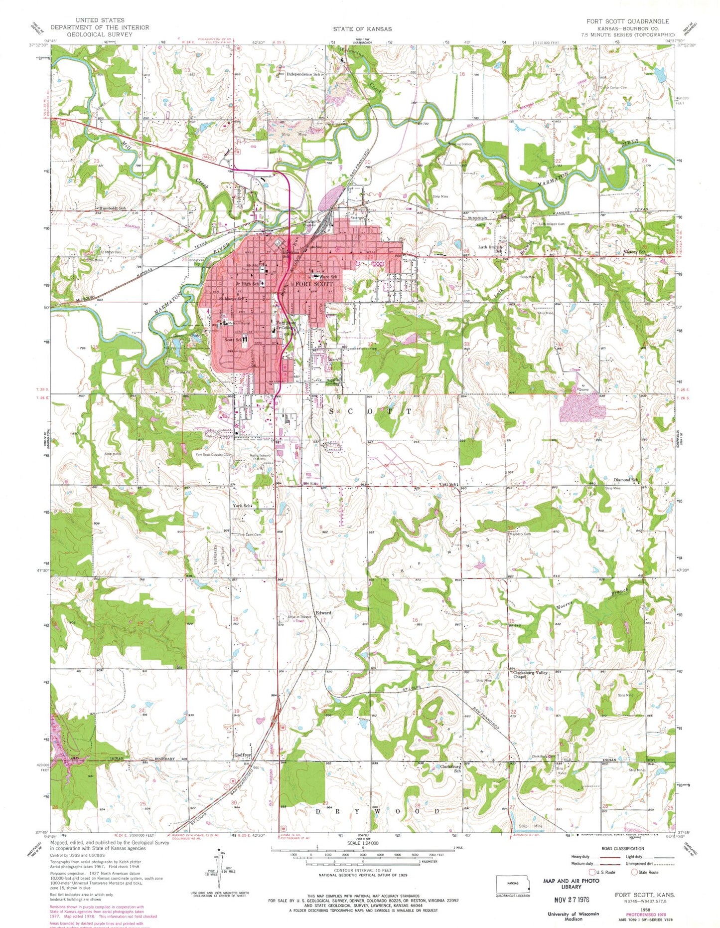
Classic USGS Fort Scott Kansas 7.5'x7.5' Topo Map
Couldn't load pickup availability
Historical USGS topographic quad map of Fort Scott in the state of Kansas. Map scale may vary for some years, but is generally around 1:24,000. Print size is approximately 24" x 27"
This quadrangle is in the following counties: Bourbon.
The map contains contour lines, roads, rivers, towns, and lakes. Printed on high-quality waterproof paper with UV fade-resistant inks, and shipped rolled.
Contains the following named places: Abundant Grace Church, Apostolic Christian Church, Apostolic Pentecostal Church, Bell School, Bourbon County Chapter American Red Cross, Bourbon County Courthouse, Bourbon County Fairgrounds, Bourbon County Public Works, Bourbon County Sheriff's Department Jail, Bourbon County Sheriff's Office, Bridal Veil Park, Buck Run, Buck Run Community Center, Catt School, Church of Christ, City of Fort Scott, Clarksburg, Clarksburg Cemetery, Clarksburg School, Clarksburg Valley Chapel, Community Christian Church, Community of Christ, Diamond School, Edward, Emmanuel Baptist Church, Eugene Ware Elementary School, Evergreen Cemetery, Faith Christian Center, First Baptist Church, First Christian Church, First Church of God, First Church of the Nazarene, First Presbyterian Church, First Southern Baptist Church, First United Methodist Church, Fort Scott, Fort Scott Area Chamber of Commerce, Fort Scott Brethren Church, Fort Scott Campground, Fort Scott Christian Heights School, Fort Scott Church of Christ, Fort Scott City Hall, Fort Scott Community College, Fort Scott Country Club, Fort Scott Fire Department, Fort Scott High School, Fort Scott Memorial Hall, Fort Scott Middle School, Fort Scott National Cemetery, Fort Scott National Historic Site, Fort Scott Police Department, Fort Scott Post Office, Fort Scott Public Library, Fort Scott Public Works, Fort Scott Seventh Day Adventist Church, Fort Scott Wastewater Treatment Plant, Fort Scott-Gunn Park Dam, Godfrey, Grace Baptist Tabernacle, Gunn Park, Hawkins School, Hickory Creek, Humboldt School, Independence School, Kingdom Hall of Jehovah's Witnesses, KMDO-AM (Fort Scott), KOMB-FM (Fort Scott), Lath Branch, Lath Branch Cemetery, Lath Branch School, Life Point Assembly of God Church, Mary Queen of Angels Catholic Church, Mayberry Cemetery, Mercy Health Center Heliport, Mercy Hospital - Fort Scott, Mill Creek, Mount Olive Church of God in Christ, Oak Grove Cemetery, Old Fort Scott, Parkway Church of God, Pine Lawn Cemetery, Presbyterian Manors of Mid - America, Ralph Richards Museum, Saint John's United Methodist Church, Saint Marys Catholic School, Saint Mary's Cemetery, Scott Township District 5 Fire Department Station 1, Scott Township District 5 Fire Department Station 2, Southeast Kansas Multi - County Health Department Bourbon County, The Church of Jesus Christ of Latter Day Saints, Township of Scott, Trinity Lutheran Church, Umstead School, Union Center Cemetery, United Missionary Baptist Church, Victory School, West Park Church of the Nazarene, Winfield Scott Elementary School, Wolverine Creek, York School