
MyTopo
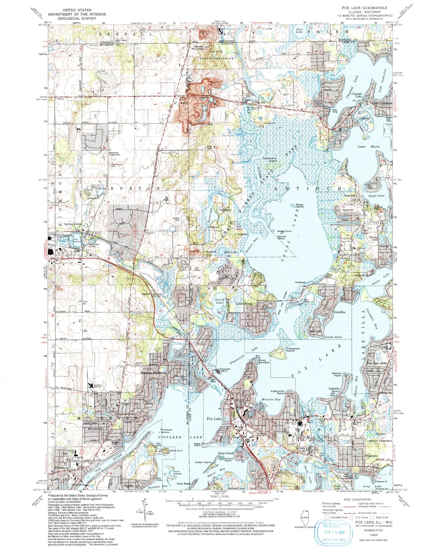
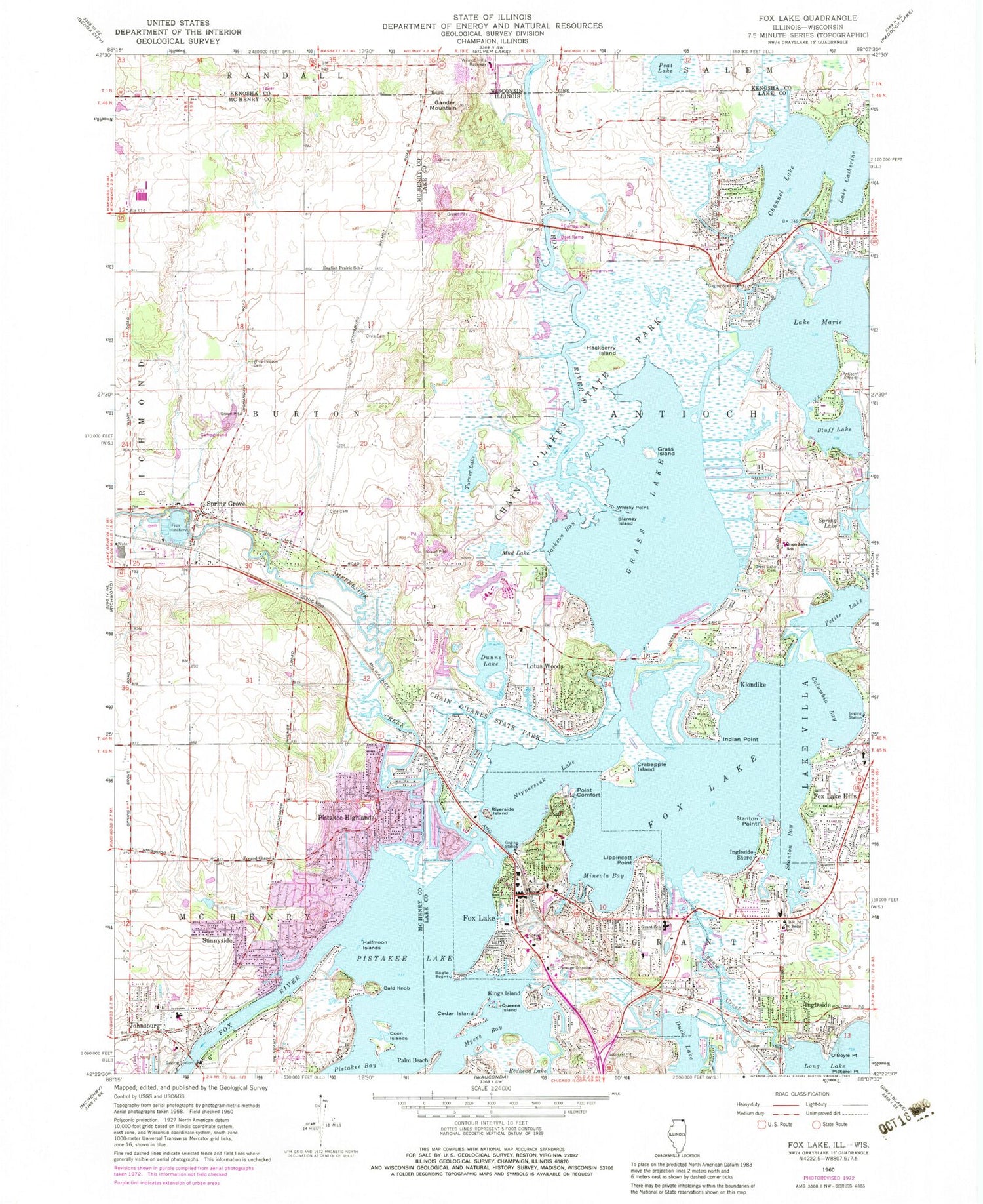
Classic USGS Fox Lake Illinois 7.5'x7.5' Topo Map
Couldn't load pickup availability
Historical USGS topographic quad map of Fox Lake in the states of Illinois, Wisconsin. Typical map scale is 1:24,000, but may vary for certain years, if available. Print size: 24" x 27"
This quadrangle is in the following counties: Kenosha, Lake, McHenry.
The map contains contour lines, roads, rivers, towns, and lakes. Printed on high-quality waterproof paper with UV fade-resistant inks, and shipped rolled.
Contains the following named places: Bald Knob, Barney Island, Bluff Lake, Lake Catherine, Cedar Island, Chain O'Lakes State Park, Channel Lake, Cole Cemetery, Columbia Bay, Coon Islands, Crabapple Island, Duck Lake, Dunns Lake, Eagle Point, English Prairie School, Fox Lake, Fox Lake, Fox Lake Hills, Muller Chapel, Gander Mountain, Grant High School, Grass Island, Grass Lake, Grass Lake Cemetery, Grass Lake Elementary School, Hackberry Island, Halfmoon Islands, Indian Point, Ingleside, Ingleside Shore, Jackson Bay, Johnsburg, Kings Island, Klondike, Lippincott Point, Long Lake, Lotus Woods, Lake Marie, Mineola Bay, Mud Lake, Nippersink Creek, O'Boyle Point, Orvis - Sanborn Cemetery, Palm Beach, Petite Lake, Pickerel Point, Pistakee Highlands, Pistakee Lake, Point Comfort, Queens Island, Riverside Island, Saint Bede School, Spring Lake, Squaw Creek, Stanton Bay, Stanton Point, Sunnyside, Turner Lake, Whisky Point, Wray - Imeson Cemetery, Pistakee, Spring Grove, Fox Lake Seaplane Base (historical), Precision Chrome Heliport, Arrow Heliport, Pillow Hill Airport, Richardson Field, Township of Burton, Kazimier Lake Dam, Kazimier Lake, Creek School (historical), English Prairie Post Office (historical), James C Bush Elementary School, Johnsburg High School, Johnsburg Junior High School, Johnsburg Middle School, Mount Hope United Methodist Church, Nippersink Canoe Base County Park, Richardsons Landing Strip (historical), Spring Grove Elementary School, Spring Grove Post Office, Sunnyside Village Hall, Thomas Memorial County Park, Antioch Airport (historical), Catfish Cove Picnic Area, Channel Lake, Channel Lake School (historical), Deer Path Picnic Area, Forest School, Gavin Central Elementary School, Gavin North Intermediate School, Grass Lake, Hickory Grove Picnic Area, Honeysuckle Hollow Camping Area, Lake Catherine, Lotus Point, Mudlake West Youth Group Camping Area, Oak Grove Picnic Area, Oak Point Day Use Area, Pike Marsh Picnic Area, Prairie View Camping Area, Stanton School, Turner Lake Fen Nature Preserve, Turner Lake South Camping Area, Spring Grove Cemetery, Gavin Bog and Prairie Nature Preserve, Fox Lake Country Club, Lakeland Shopping Center, Gander Mountain Forest Preserve, Meadowland Community Church, Saint Peter Church, Grant Woods Forest Preserve, Spring Grove Fen Nature Preserve, Weingart Road Sedge Meadow Nature Preserve, Nippersink Lake, Fox Lake Regional Sewage Treatment Plant, Fox Lake Hills Census Designated Place, Lake Catherine Census Designated Place, Long Lake Census Designated Place, Pistakee Highlands Census Designated Place, Channel Lake Census Designated Place, Village of Johnsburg, Village of Fox Lake, Village of Spring Grove, Richardson Farm, Midland Airport, Fox Lake Fire Department Station 2, Fox Lake Fire Department Station 1, Spring Grove Fire Protection District, McHenry Township Fire Protection District Station 2, Fox Lake Fire Department Station 4, Village of Johnsburg Police Department, Fox Lake Police Department, Spring Grove Police Department, Ingleside Post Office, Fox Lake Post Office, Peat Lake, Wilmot Hills Raceway, Eagle Lake 3WR1658 Dam, Eagle Lake 7, Peat Lake State Natural Area, Oriole Springs Orchard


