MyTopo
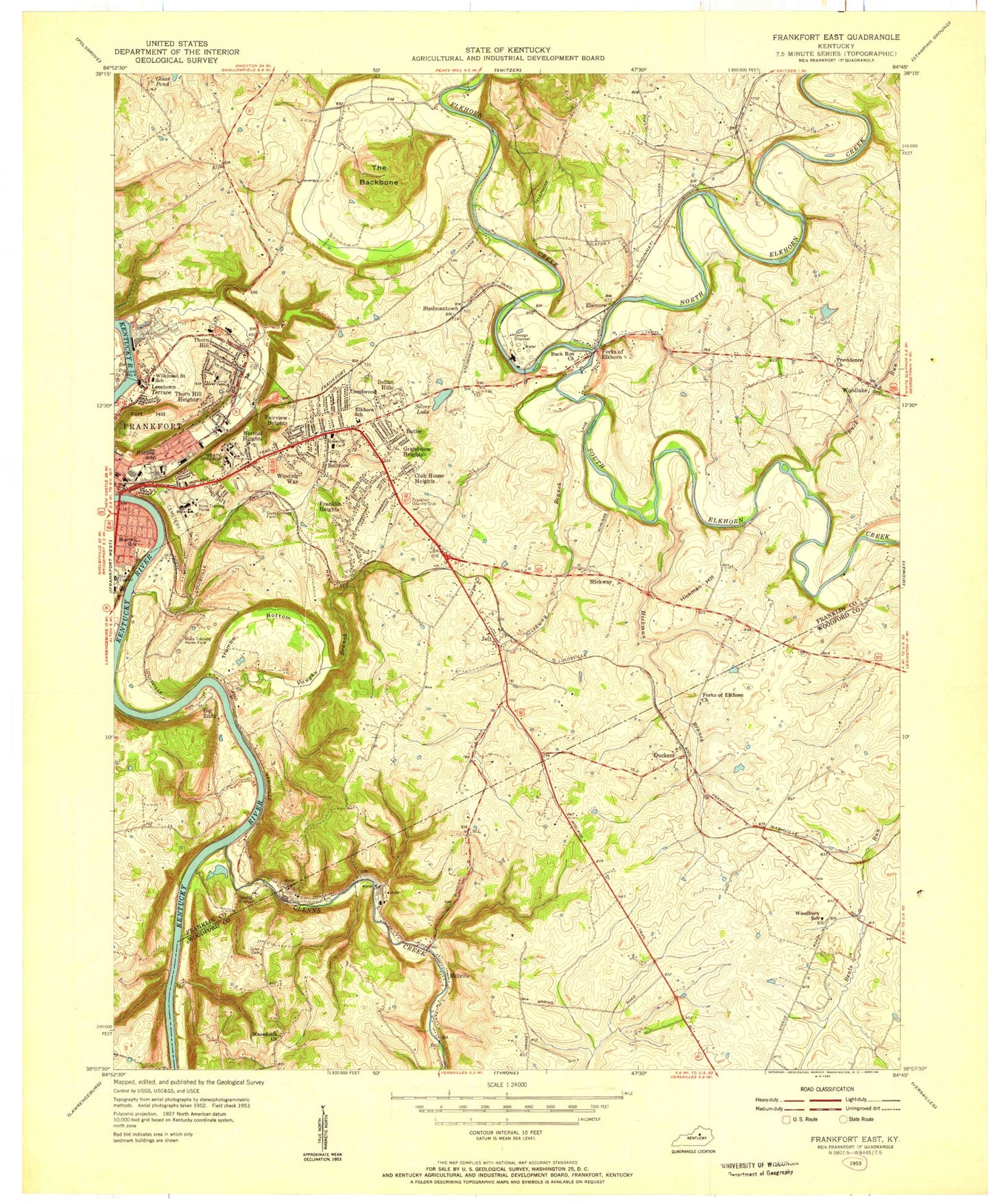
Classic USGS Frankfort East Kentucky 7.5'x7.5' Topo Map
Couldn't load pickup availability
Historical USGS topographic quad map of Frankfort East in the state of Kentucky. Typical map scale is 1:24,000, but may vary for certain years, if available. Print size: 24" x 27"
This quadrangle is in the following counties: Franklin, Woodford.
The map contains contour lines, roads, rivers, towns, and lakes. Printed on high-quality waterproof paper with UV fade-resistant inks, and shipped rolled.
Contains the following named places: Bon Air Hills, Buck Run, Crestwood Church, Duckers, Elkhorn Middle School, Elsinore, Forks of Elkhorn, Forks of Elkhorn Church, Fort Hill, Frankfort State Hospital, Frankfort State School, Glenns Creek, Green Hill Cemetery, Hickman Branch, Hickman Hill, Highland Church, Holmes Saint School, Indian Hills, Jett, Kentucky State University, Macedonia Church, Millville, North Elkhorn Creek, Penitentiary Branch, Silver Lake, Slickway Branch, South Elkhorn Creek, South Trimble Memorial Bridge, Sunset Memorial Gardens, The Backbone, Thorn Hill School, Trumbo Bottom, Vaughn Branch, Woodlake, Big Eddy, Slickway, East School, Frankfort County High School, Murray Street School, Wilkinson Street School, Frankfort Country Club, Lock and Dam Number 4, Frankfort, WVBA-FM (Frankfort), Frankfort Division, City of Frankfort, Canty Branch, Duckers Railroad Station (historical), Glenns Creek Railroad Station (historical), Dorsey Post Office (historical), Dorsey Tavern (historical), Grassy Spring Church (historical), Grassy Spring School (historical), Buckley Wildlife Sanctuary, Thompsons Fort (historical), Millville Railroad Station (historical), Taylorton Railroad Station (historical), Millville Post Office (historical), Miles Mill (historical), Cook Cemetery, North Fork Glenns Creek, Canewood Farm (historical), Woodburn School (historical), Old Taylor Distillery (historical), Old Crow Distillery, Spring Garden Farm (historical), Perrys Mill (historical), Elm Grove (historical), Duckers Post Office (historical), Harmony Presbyterian Church (historical), Jett Post Office (historical), New Post Office (historical), Capitol View Park, Jones Railroad Station (historical), Poplar Hill, Arnolds Station (historical), Belair Farm (historical), Bells Grove Farm (historical), Brighton Park Mill (historical), Buck Run School (historical), Buffalo Trace Distillery, Camp Madison (historical), Churches Schoolhouse (historical), Cliffside Railroad Station (historical), Cove Spring (historical), DeShon School (historical), Elkhorn Campground, Elkhorn Mills (historical), Elsinore Railroad Station (historical), Excelsior Institute (historical), Forks of Elkhorn Post Office (historical), Foster Tavern (historical), Frankfort Cemetery, Frankfort Tabernacle Church (historical), Gores Station (historical), Haydons Station (historical), Hickman Branch South Elkhorn Creek, Hoge, John Major Station (historical), Llangollen Farm (historical), Locust Grove Spring (historical), Macklin Mill (historical), Pond Spring (historical), Redstone Hall (historical), Roaring Spring, Saffells Bend, School Number Eleven (historical), School Number Nine (historical), School Number Thirty (historical), Silver Lake Farm (historical), Steadmanville Mill (historical), Steadmanville Post Office (historical), Trumbo Railroad Station (historical), Valley Farm (historical), White School (historical), Wood Lake, Woodlake Farm (historical), Woodlake Post Office (historical), Yeatmans Branch, Graben Tavern (historical), Jett Railroad Station (historical), Locust Hill, Macklin Mill Dam (historical), Mount Pleasant Church (historical), Oakley Post Office (historical), Franklin County Fire Department Station 8 Industrial Park Station, Frankfort City Fire Department Station 4, Frankfort City Fire Department Station 2, Franklin County Fire Department Station 5, Kentucky Division of Forestry Bluegrass District, Glen Willis Historical Marker, Buena Vista Historical Marker, Student Branch, Franklin County Sheriff's Office, Frankfort Post Office, Bon Air Hills, Buck Run, Crestwood Church, Duckers, Elkhorn Middle School, Elsinore, Forks of Elkhorn, Forks of Elkhorn Church, Fort Hill, Frankfort State Hospital, Frankfort State School, Glenns Creek, Green Hill Cemetery, Hickman Branch, Hickman Hill, Highland Church, Holmes Saint School, Indian Hills, Jett, Kentucky State University, Macedonia Church, Millville, North Elkhorn Creek, Penitentiary Branch, Silver Lake, Slickway Branch, South Elkhorn Creek, South Trimble Memorial Bridge, Sunset Memorial Gardens, The Backbone, Thorn Hill School, Trumbo Bottom, Vaughn Branch, Woodlake, Big Eddy, Slickway, East School, Frankfort County High School, Murray Street School, Wilkinson Street School, Frankfort Country Club, Lock and Dam Number 4, Frankfort, WVBA-FM (Frankfort), Frankfort Division, City of Frankfort, Canty Branch, Duckers Railroad Station (historical), Glenns Creek Railroad Station (historical), Dorsey Post Office (historical), Dorsey Tavern (historical), Grassy Spring Church (historical), Grassy Spring School (historical), Buckley Wildlife Sanctuary, Thompsons Fort (historical), Millville Railroad Station (historical), Taylorton Railroad Station (historical), Millville Post Office (historical), Miles Mill (historical), Cook Cemetery, North Fork Glenns Creek, Canewood Farm (historical), Woodburn School (historical), Old Taylor Distillery (historical), Old Crow Distillery, Spring Garden Farm (historical), Perrys Mill (historical), Elm Grove (historical), Duckers Post Office (historical), Harmony Presbyterian Church (historical), Jett Post Office (historical), New Post Office (historical), Capitol View Park, Jones Railroad Station (historical), Poplar Hill, Arnolds Station (historical), Belair Farm (historical), Bells Grove Farm (historical), Brighton Park Mill (historical), Buck Run School (historical), Buffalo Trace Distillery, Camp Madison (historical), Churches Schoolhouse (historical), Cliffside Railroad Station (historical), Cove Spring (historical), DeShon School (historical), Elkhorn Campground, Elkhorn Mills (historical), Elsinore Railroad Station (historical), Excelsior Institute (historical), Forks of Elkhorn Post Office (historical), Foster Tavern (historical), Frankfort Cemetery, Frankfort Tabernacle Church (historical), Gores Station (historical), Haydons Station (historical), Hickman Branch South Elkhorn Creek, Hoge, John Major Station (historical), Llangollen Farm (historical), Locust Grove Spring (historical)


