MyTopo
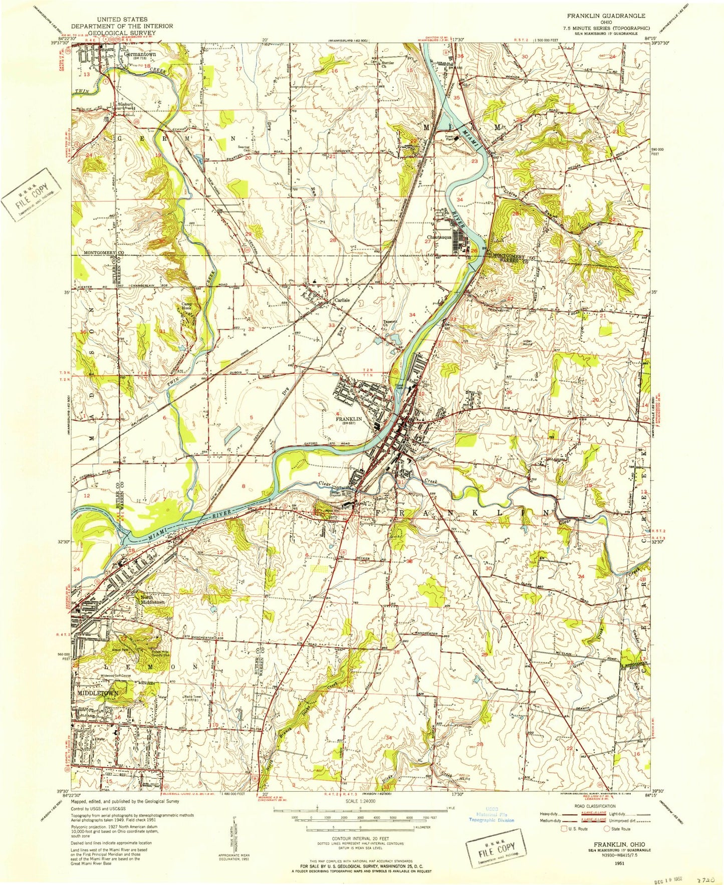
Classic USGS Franklin Ohio 7.5'x7.5' Topo Map
Couldn't load pickup availability
Historical USGS topographic quad map of Franklin in the state of Ohio. Map scale may vary for some years, but is generally around 1:24,000. Print size is approximately 24" x 27"
This quadrangle is in the following counties: Butler, Montgomery, Warren.
The map contains contour lines, roads, rivers, towns, and lakes. Printed on high-quality waterproof paper with UV fade-resistant inks, and shipped rolled.
Contains the following named places: Anthony Wayne Elementary School, Armco Park, Camp Hook, Carlisle, Carlisle Cemetery, Carlisle Fire Department, Carlisle First Church of God, Carlisle High School, Carlisle Intermediate School, Carlisle Middle School, Carlisle Police Department, Carlisle Post Office, Carlisle Primary School, Chautaugua Post Office, Chautauqua, Chautauqua Dam, Chautauqua Post Office, Chautauqua Reservoir, Christ United Methodist Church, Christian Enterprise Baptist Church, Church of God, Church of the Nazarene, City of Franklin, City of Middletown, Clear Creek, Conover Hospital, Crains Run, Creekview Elementary School, Dave Finkelman Auditorium, Dixie Heights Park, Downing Park, Dry Run, Eastgate Plaza Shopping Center, Eighth Street Church of God, Eldorado, Fenwick High School, First Baptist Church, First Church of Christ Scientist, First Church of God of Franklin, First Presbyterian Church, First United Methodist Church of Franklin, Franklin, Franklin City Police Department, Franklin Division of Fire, Franklin Golf Course, Franklin High School, Franklin Junior High School, Franklin Lions Club Municipal Park, Franklin Post Office, Franklin Square Shopping Center, Franklin Township Fire Department Station 20, Franklin Township Hall, Fresh Air Camp, Gander Run, Gardner-Harvey Library, George A Gerke Elementary School, Germantown Post Office, Good Shepherd United Methodist Church, Goose Creek, Greenwood Church, Hempton Benrott Middle School, Heritage Christian School, Homan Park, Hummel Airport, Hutchins Station Reservoir, Ideal Mobile Home Park, Jacot Park, Jaygee Industrial Park, Jill Lane Park, Joint Emergency Medical Services, Joint Emergency Medical Services Station 20, Kitty Hawk Plaza Shopping Center, Laura Farrell Elementary School, Laynecrest Plaza Shopping Center, Little Mount, Little Twin Creek, Logan T Johnston Hall, Madison Industrial Park, Manchester Junior High School, Maple Park, Maple Park School, Messiah Lutheran Church, Miami River County Park, Miami Township Fire Department Station 47, Miami University Middletown Branch, Middletown Dam, Middletown Fire Department Station 85, Middletown High School, Middletown Reservoir, Middletown Shopping Center, Midway Meadows Office Park, Midway Plaza Shopping Center, Mount Olive Church, North Middletown, O H Hutchings Station Dam, Pennyroyal Elementary School, Rickard Acres, Riverview Baptist Church, Rosedale Elementary School, Saint Johns United Church of Christ, Saint Mary Catholic Church, Saint Marys School, Saint Paul Lutheran Church, Saint Pauls Evangelical Lutheran Church, School Number 12, Second Baptist Church, Second Street School, Smitty's Trailer Court, South Public School, Spring Hill School, Springboro Business Park, Springboro Post Office, Stettler Cemetery, Stettler Church, Sunbury, Swartzel Cemetery, Tapscott Cemetery, Tapscott Primitive Baptist Church, Temple Baptist Church, Thesken Hall, Township of Franklin, Twin Creek, Twin Creek Park, Tytus Avenue First Church of God, Verity Student Center, Village of Carlisle, Whistlestop Shopping Center, Wildwood Elementary School, Wildwood Golf Club, Wildwood Park, William C Schenck Elementary School, Wilson Elementary School, Wilson Park, Woodhill Cemetery, WPBF-FM (Middletown), WPFB-AM (Middletown), Zion Lutheran Church, ZIP Code: 45005