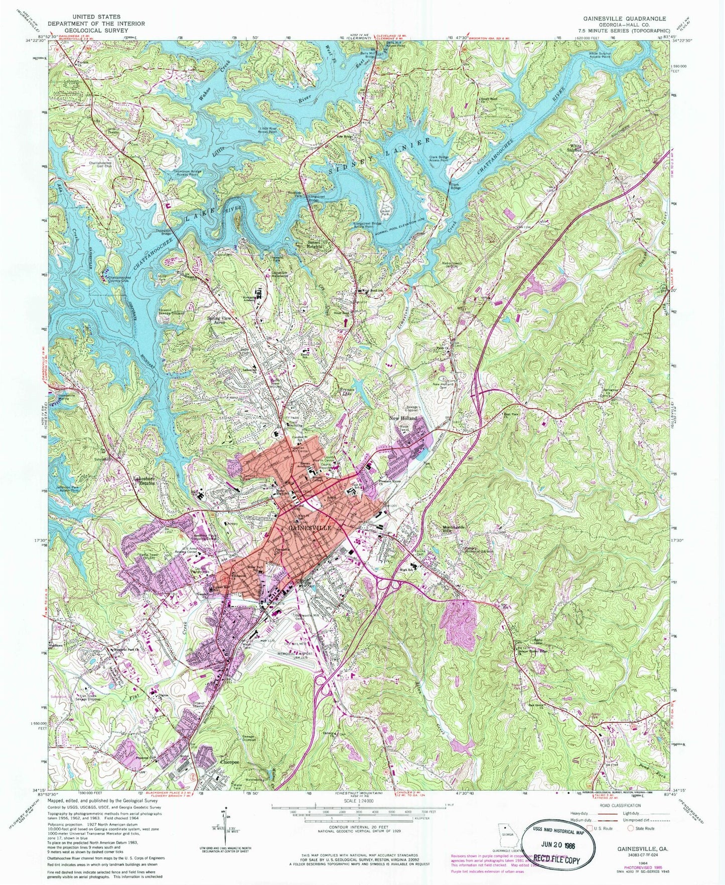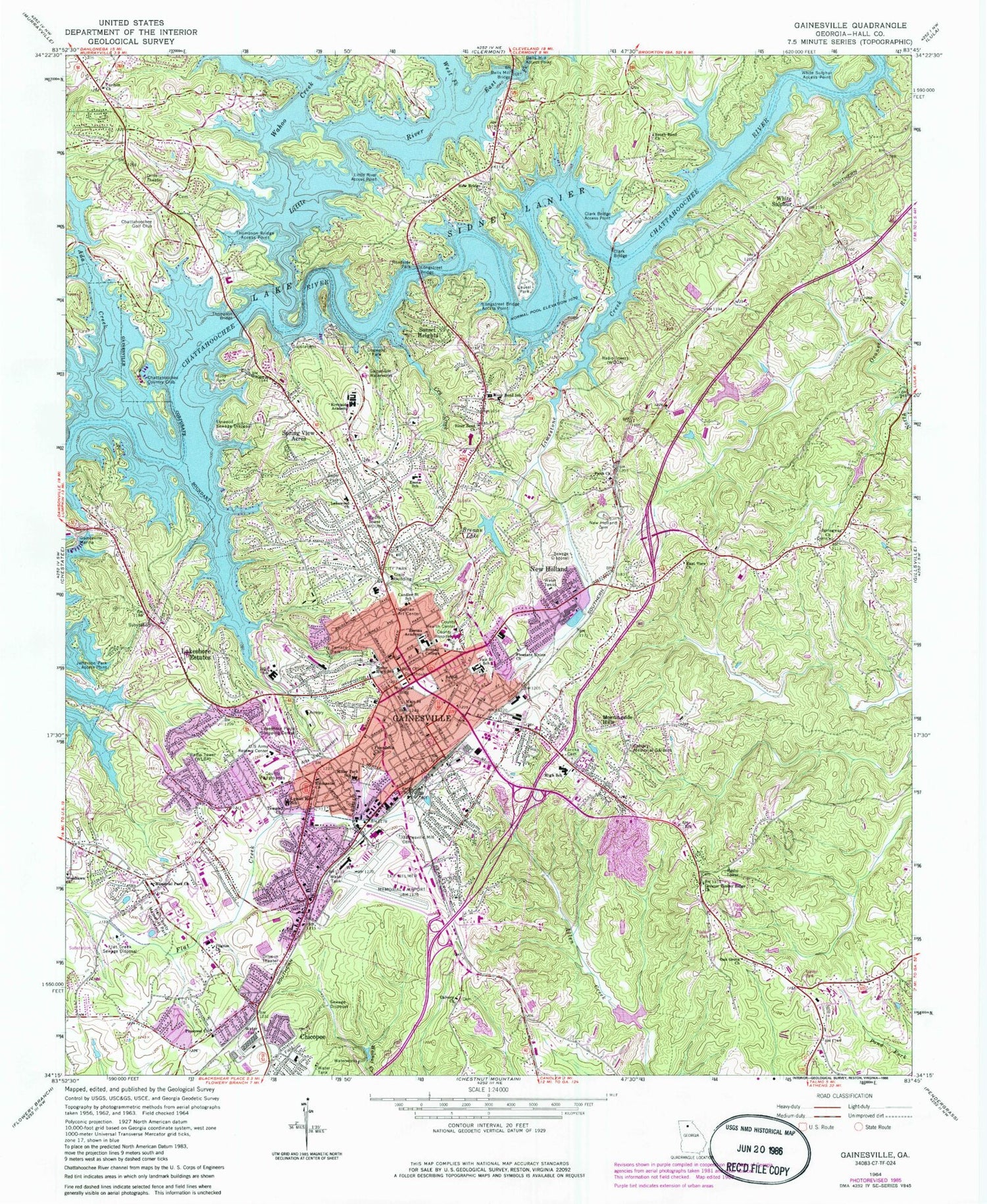
MyTopo
Classic USGS Gainesville Georgia 7.5'x7.5' Topo Map
Couldn't load pickup availability
Historical USGS topographic quad map of Gainesville in the state of Georgia. Map scale may vary for some years, but is generally around 1:24,000. Print size is approximately 24" x 27"
This quadrangle is in the following counties: Hall.
The map contains contour lines, roads, rivers, towns, and lakes. Printed on high-quality waterproof paper with UV fade-resistant inks, and shipped rolled.
Contains the following named places: Ada Creek, Ahaluna, Air Line School, Airline Cemetery, Airline School, Airport Industrial Park, Alpine Educational Program School, Alta Vista Cemetery, Atlas Circle, Bailey, Bamboo Village Shopping Center, Barrett, Bells Mill Access Point, Bells Mill Bridge, Bethel Church, Beverly Hills, Blue Ridge Shopping Center, Blueberry Hills, Botany Woods, Brenau Academy, Brenau College Historic District, Brenau Lake, Brenau Lake Dam, Brenau University, Broad Street Shopping Center, Calvary Baptist Cemetery, Calvary Church, Calvary Memorial Gardens, Camellia Heights, Candler Street School, Cascade Woods, Centennial Elementary School, Centennial Industrial Park, Chapman, Chattahoochee Country Club, Chattahoochee Golf Club, Chattahoochee Landing, Chattahoochee Place, Cherokee Meadows, Cherrywood, Chestnut Oak Hills, Chicopee, Chicopee Mill and Village Historic District, City of Gainesville, Clark Bridge, Clark Bridge Access Point, Clarks Bridge, Corinth Baptist Cemetery, Cornith Church, Country Club Gardens, Cry Creek, Dixie Hills, Dogwood Park, East Fork Little River, East View Church, Emmanuel Church, Enota Elementary School, Fair Street Elementary School, Faith Church, Flat Creek Sewage Disposal, Fleetwood, Fox Hollow, Friendship Church, Frontier Trail, Gainesville, Gainesville Carrier Annex Post Office, Gainesville Christian School, Gainesville City Hall, Gainesville Civic Center, Gainesville Division, Gainesville Exploration Academy, Gainesville Fire Department Station 1, Gainesville Fire Department Station 2, Gainesville Fire Department Station 3, Gainesville Fire Department Station 4, Gainesville High School, Gainesville Industrial Park North, Gainesville Industrial Park South, Gainesville Learning Academy, Gainesville Marina, Gainesville Middle School, Gainesville Mill Cemetery, Gainesville Mill School, Gainesville Mills, Gainesville Police Department, Gainesville Police Department Featherbone Communiversity Precinct, Gainesville Police Department Mall Precinct, Gainesville Police Department Melrose Precinct, Gainesville Post Office, Gainesville Waterworks, Gainesville West Shopping Center, Georgia State Patrol Troop B Post 6 Gainesville, Good Shepard Lutheran School, Gower Springs, Greater Timber Ridge Church, Green Hills, Green Street-Brenau Historic District, Greenway, Greystone, Griffin Heights, Hall County, Hall County Courthouse, Hall County Fire Services Station 21, Hall County Fire Station 1, Hall County Fire Station 7, Hall County Sheriff's Office, Happy Valley, Hayes, Highway Fiftythree Access Point, Holland, Holly Park, Interactive College of Technology Gainesville Campus, Ivy Terrace Park, Jefferson Park Access Point, Jones Elementary School, Jubilee Christian Academy, Kemp, Lakeland Heights, Lakeshore Estates, Lakeshore Plaza Shopping Center, Lakeshore Village Shopping Center, Lakeview Academy, Lakewood Church, Lanier North Woods, Lanier Park Hospital Heliport, Lanier Plaza Shopping Center, Lanier Valley, Laurel Hills, Laurel Park, Le Dan, Lee Gilmer Memorial Airport, Limestone Creek, Limestone Post Office, Linwood Sewage Disposal, Little River, Little River Access Point, Longstreet Bridge, Longstreet Bridge Access Point, Lyman Hall Elementary School, Lyman Hall School, Main Street School, McEvers Corners Shopping Center, Memorial Park Cemetery, Memorial Park Church, Middle Oconee Structure Number Seven Dam, Mill Creek, Miller Park School, Mooney, Morning Side Hills, Naval Air Facility Gainesville, New Bridge Baptist Cemetery, New Bridge Church, New Gainesville Middle School, New Holland, New Holland Cemetery, New Holland Core Knowledge Academy, New Life Baptist Cemetery, North Banks Cove, North Georgia Christian School, North Horizons Lanier Park Health Center, Northcliff Colony, Northeast Georgia Medical Center, Northlake, Northlake Plaza Shopping Center, Oak Grove Baptist Cemetery, Oak Grove Baptist Church, Oakhill, Pilgrim Church, Pine Point, Pinecrest Church, Pleasant Union Church, Quiet Place in the Woods, Quinlan Art Center, Rabbitown, Rainbow Village, Ramsey-Fraser Lake, Ramsey-Fraser Lake Dam, Reservoir Seven, River Bend Church, River Point, Riverbend, Riverbend Elementary School, Riverside Military Academy, Roper Park, Sagamore, Scoutland, Shady Lane, Shady Valley, Shamrock Heights, Sherwood Plaza Shopping Center, South Bend Church, South Bend Methodist Cemetery, Spring View Acres, Springway Baptist Cemetery, Springway Church, Stevens, Sundown on Lanier, Sunset Heights, Surf Side Club Estates, Tapawingo, Temple Church, The Bluffs, The International Center, Thompson Bridge, Thompson Bridge Access Point, Thompson Mill, Town View Plaza Shopping Center, Tumlin Heights, Tyner, Wahoo Creek, Washington Plaza Shopping Center, Washington Square Shopping Center, Waterford, WBCX-FM (Gainesville), WDUN-AM (Gainesville), West Fork Little River, Westgate, Westside, Westside Post Office, Westside Shopping Center, WGGA-AM (Gainesville), White Sands, White Sulphur, White Sulphur Access Point, White Sulphur Elementary School, White Sulphur Springs, White Sulphur Station, Wild Fern, Wildwood Heights, WLBA-AM (Gainesville), Woodlake, Woodlawn Cemetery, Woodlawn Church, Yonah Park, ZIP Code: 30501