MyTopo
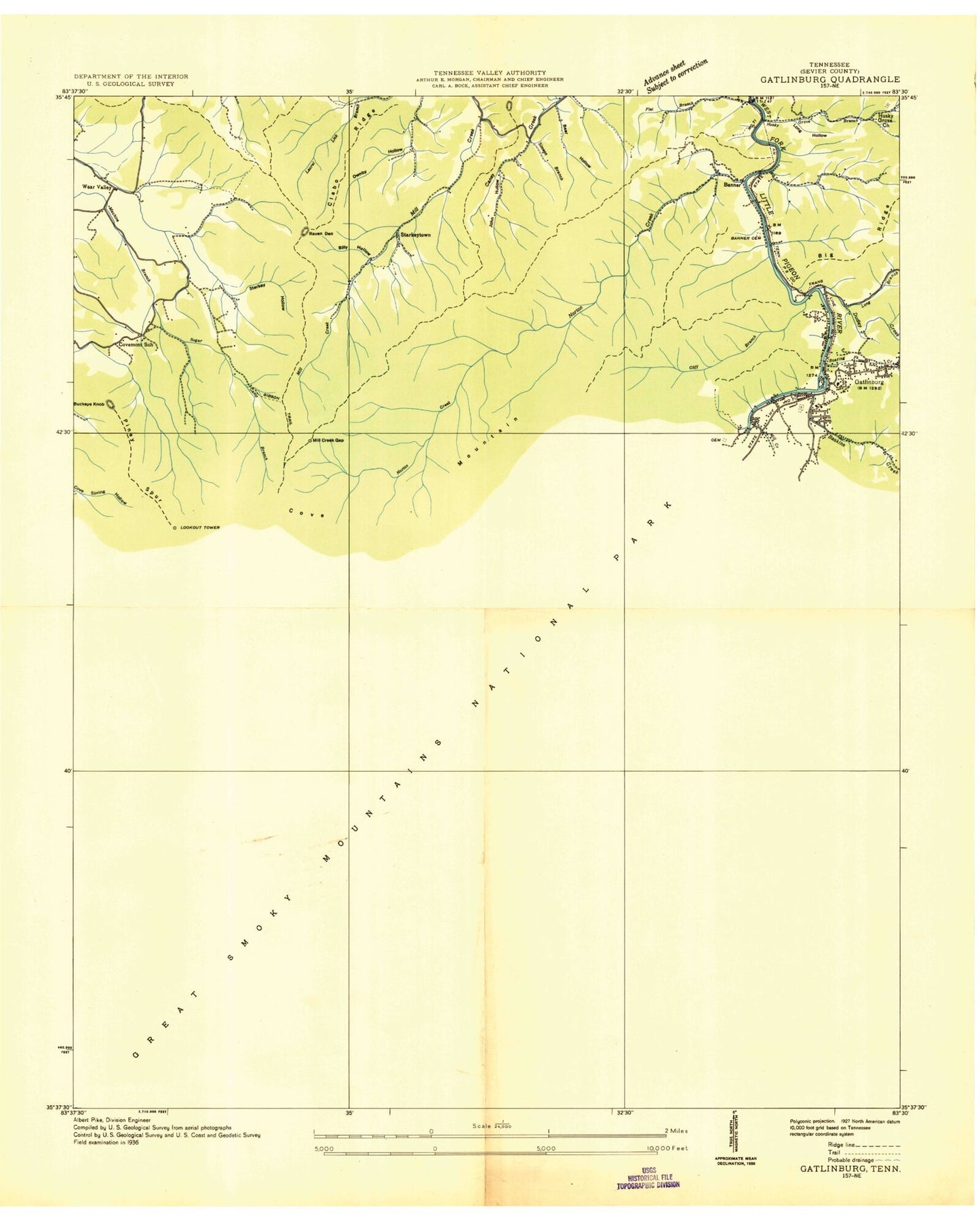
Classic USGS Gatlinburg Tennessee 7.5'x7.5' Topo Map
Couldn't load pickup availability
Historical USGS topographic quad map of Gatlinburg in the state of Tennessee. Typical map scale is 1:24,000, but may vary for certain years, if available. Print size: 24" x 27"
This quadrangle is in the following counties: Sevier.
The map contains contour lines, roads, rivers, towns, and lakes. Printed on high-quality waterproof paper with UV fade-resistant inks, and shipped rolled.
Contains the following named places: Jakes Creek Trail, Pine Knot Branch, Shields Branch, Shinbone Ridge, Slick Limb Branch, Sloan Ridge, Spring Branch, Starkey Gap, Starkey Hollow, Steep Branch, Sugar Camp Branch, Sugar Orchard Branch, Sugarland Branch, Sugarland Mountain Trail, Tanager Branch, The Sugarlands, Third Branch, Trotter Camp, Twin Creeks Uplands Research Laboratory, Twomile Branch, Twomile Lead, Upland Branch, Watercrease Branch, Whistlepig Branch, Arrowhead Branch, Ash Hopper Branch, Banner Cemetery, Baskins Creek, Bearpen Gap, Bearwallow Branch, Bearwallow Gap, Bearwallow Hollow, Beech Branch, Bent Field, Big Branch, Bill Deadening Branch, Billy Hollow, Blanket Creek, Blanket Mountain, Briar Knob, Brushy Ridge, Buckberry Branch, Buckeye Knob, Bullhead Branch, Burnt Mountain, Campbell Lead, Caney High Top, Carr Branch, Catron Branch, Chalet Village, Chinquapin Knob, Chinquapin Ridge, Clabo Ridge, Cliff Branch, Cove Mountain, Cove Mountain Trail, Critter Branch, Crooked Arm Ridge, Cucumber Gap, Dan Hollow, Double Gourd Branch, Dry Pond Branch, Dudley Bluff, Dudley Creek, Elkmont, Elkmont Ranger Station, Fighting Creek, Fighting Creek Gap, First Branch, Flat Branch, Flint Rock Branch, Fox Hole Branch, Greystone Heights, Groundhog Branch, Mount Harrison, Henderson Branch, Hickory Flats Branch, Hickory King Branch, Holy Branch, Holy Butt, Huskey Branch, Huskey Gap, Huskey Grove Branch, Jay Bird Branch, Joe Hollow, John Hollow, King Hollow Branch, King Hollow Spring, Kiver Branch, Laurel Branch, Laurel Falls, Laurel Falls Trail, Long Branch, Long Hollow, Maloney Point, Mannis Branch, Meigs Mountain, Middle Ridge, Mids Branch, Mids Gap, Mill Creek Gap, Millsap Branch, Mynatt Park, Newt Prong, Norton Creek, Ownby Hollow, Parton Branch, Phils View, Pinestand Ridge, Piney Butt, Piney Spur, Poplar Branch, Ramp Creek, Raven Den, Red Bird Branch, Roaring Fork, Roberts Branch, Rocky Ridge, Rymel Branch, Sawmill Branch, Second Branch, Seng Branch, Jakes Creek, Sugar Maple Branch, Sugarlands Visitor Center, Thirst Branch, Tulip Branch, Valley View Church, Waterdog Branch, Wear Cove, Agana Branch, Banner Church, Big Hollow, Big Medicine Branch, Cataract Branch, Cherry Branch, Cherry Gap, Covemont Church, Crowson Cemetery, Grassy Branch, Huskey Grove Church, Ownby Cemetery, Painter Branch, Phoebe Branch, Rattlebox Branch, Road Turn Branch, Norton Creek Ranch, Shandy Hollow, Sugar Branch, Starkeytown, Banner School (historical), Covemont School (historical), First Baptist Church, First United Methodist Church, Gatlinburg Church of Christ, Gatlinburg Presbyterian Church, Holston Assembly Grounds (historical), Jim Carr Mill (historical), Millsap Picnic Grounds, Mountain Mall Shopping Center, Our Saviour Lutheran Church, Park Plaza Shopping Center, Pi Beta Phi Elementary School, Saint Marys Catholic Church, Sugarlands Utility Area (historical), Twin Creeks Government Headquarters (historical), Village Shopping Center, Windmill Towne Shopping Center, WVTN-FM (Gatlinburg), Cole Cemetery, Elkmont - Wonderland Cemetery, Fighting Creek Cemetery, Evans Chapel Cemetery, Huskey Grove Cemetery, Lower Fighting Creek Cemetery, I N Trentham Cemetery, Valley View Cemetery, White Oak Flats Cemetery, Gatlinburg, King Branch Campsite, Medicine Branch Bluff Campsite, Le Conte Creek, Camp Le Conte, Gatlinburg Fire Department Station 2, Gatlinburg Fire Department Station 3, Gatlinburg Space Needle, Elkmont Group Campground, Elkmont Campground, Gatlinburg Welcome Center, Burton Ogle Cemetery, Levi Trentham Cemetery, N S McCarter Cemetery, Old Sugarlands Cemetery, Vance Newman Cemetery, Jakes Creek Trail, Pine Knot Branch, Shields Branch, Shinbone Ridge, Slick Limb Branch, Sloan Ridge, Spring Branch, Starkey Gap, Starkey Hollow, Steep Branch, Sugar Camp Branch, Sugar Orchard Branch, Sugarland Branch, Sugarland Mountain Trail, Tanager Branch, The Sugarlands, Third Branch, Trotter Camp, Twin Creeks Uplands Research Laboratory, Twomile Branch, Twomile Lead, Upland Branch, Watercrease Branch, Whistlepig Branch, Arrowhead Branch, Ash Hopper Branch, Banner Cemetery, Baskins Creek, Bearpen Gap, Bearwallow Branch, Bearwallow Gap, Bearwallow Hollow, Beech Branch, Bent Field, Big Branch, Bill Deadening Branch, Billy Hollow, Blanket Creek, Blanket Mountain, Briar Knob, Brushy Ridge, Buckberry Branch