MyTopo
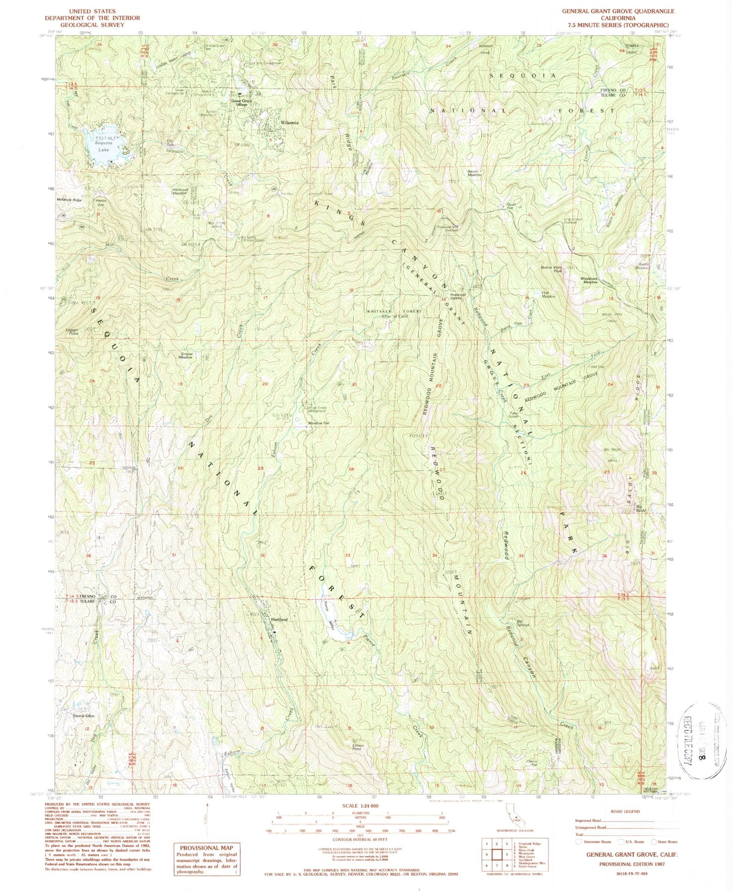
Classic USGS General Grant Grove California 7.5'x7.5' Topo Map
Couldn't load pickup availability
Historical USGS topographic quad map of General Grant Grove in the state of California. Typical map scale is 1:24,000, but may vary for certain years, if available. Print size: 24" x 27"
This quadrangle is in the following counties: Fresno, Tulare.
The map contains contour lines, roads, rivers, towns, and lakes. Printed on high-quality waterproof paper with UV fade-resistant inks, and shipped rolled.
Contains the following named places: Fox Flat, Weston Meadow, Whitaker Forest, Woodcock Meadow, Azalea Campground, Bacon Meadow, Bearskin Grove, Big Baldy Grove, Big Baldy Ridge, Big Springs, Big Stump Entrance Station, Big Stump Grove, Buena Vista Creek, Buena Vista Grove, Cherry Flat, Crystal Springs Campground, Fallen Goliath, Grouse Meadow, Happy Gap, Hart Meadow, Hart Tree, Hitchcock Meadow, Kings Canyon Overlook, Log Corral Meadow, Logger Point, Meadow Flat, Park Ridge, Pierce Valley, Quail Flat, Rabbit Meadow, Redwood Mountain, Redwood Mountain Grove, Redwood Saddle, Sequoia Creek, Sequoia Guard Station, Sequoia Lake, General Grant Grove, General Grant Grove Section Kings Canyon Nat, Sunset Campground, Swale Campground, Tenmile Grove, Baumans Cow Camp, Western Camp, Grant Grove Ranger Station, Big Baldy, Eshom Point, Hartland, Wilsonia, Sequoia Lake 693 Dam, KJOI-FM (Dinuba), KSJV-FM (Fresno), KZZF-FM (Hanford), KBOS-FM (Tulare), KSEQ-FM (Visalia), KFSO-FM (Visalia), KARM-FM (Visalia), KQKX-FM (Woodlake), KQKX-FM (Woodlake), KMPH-TV (Visalia), General Grant Tree, Ella Falls, Eshom Creek Campground, Grant Grove Village, Redwood Mountain Overlook, Hartland Census Designated Place, Wilsonia Census Designated Place, Buena Vista Peak