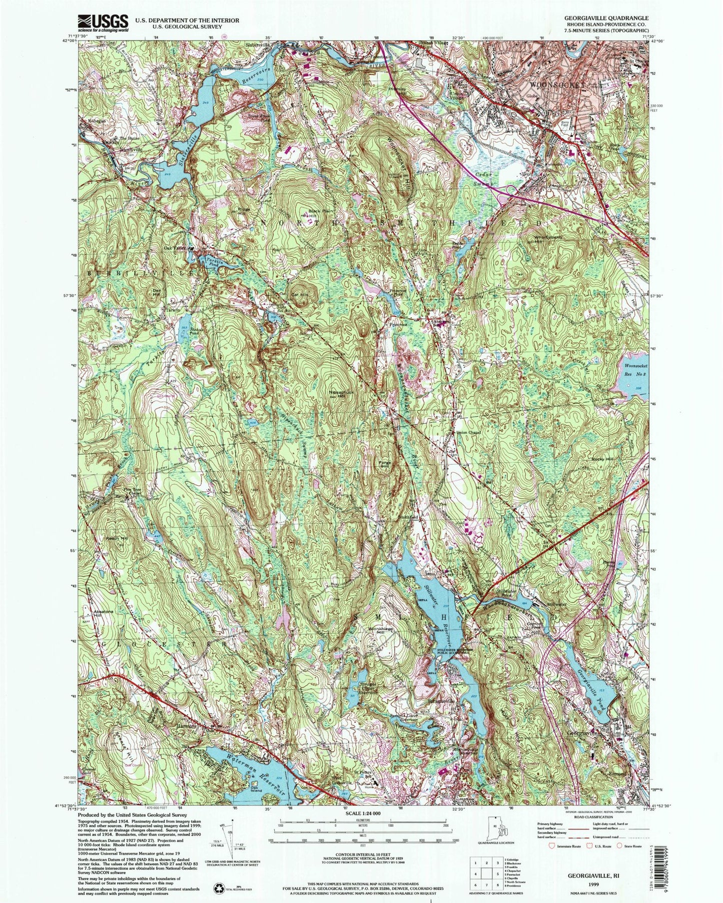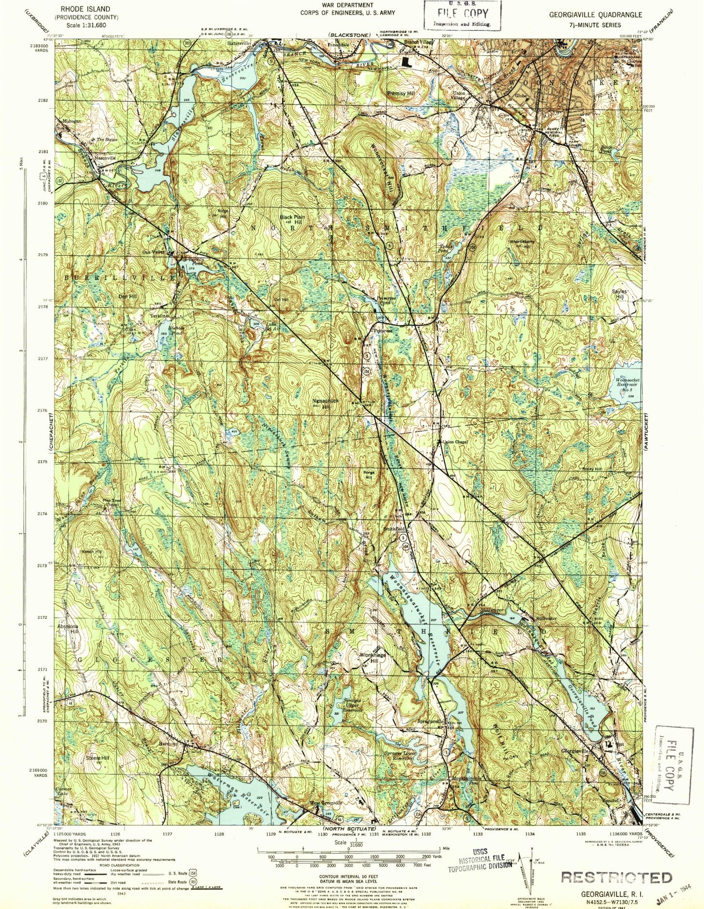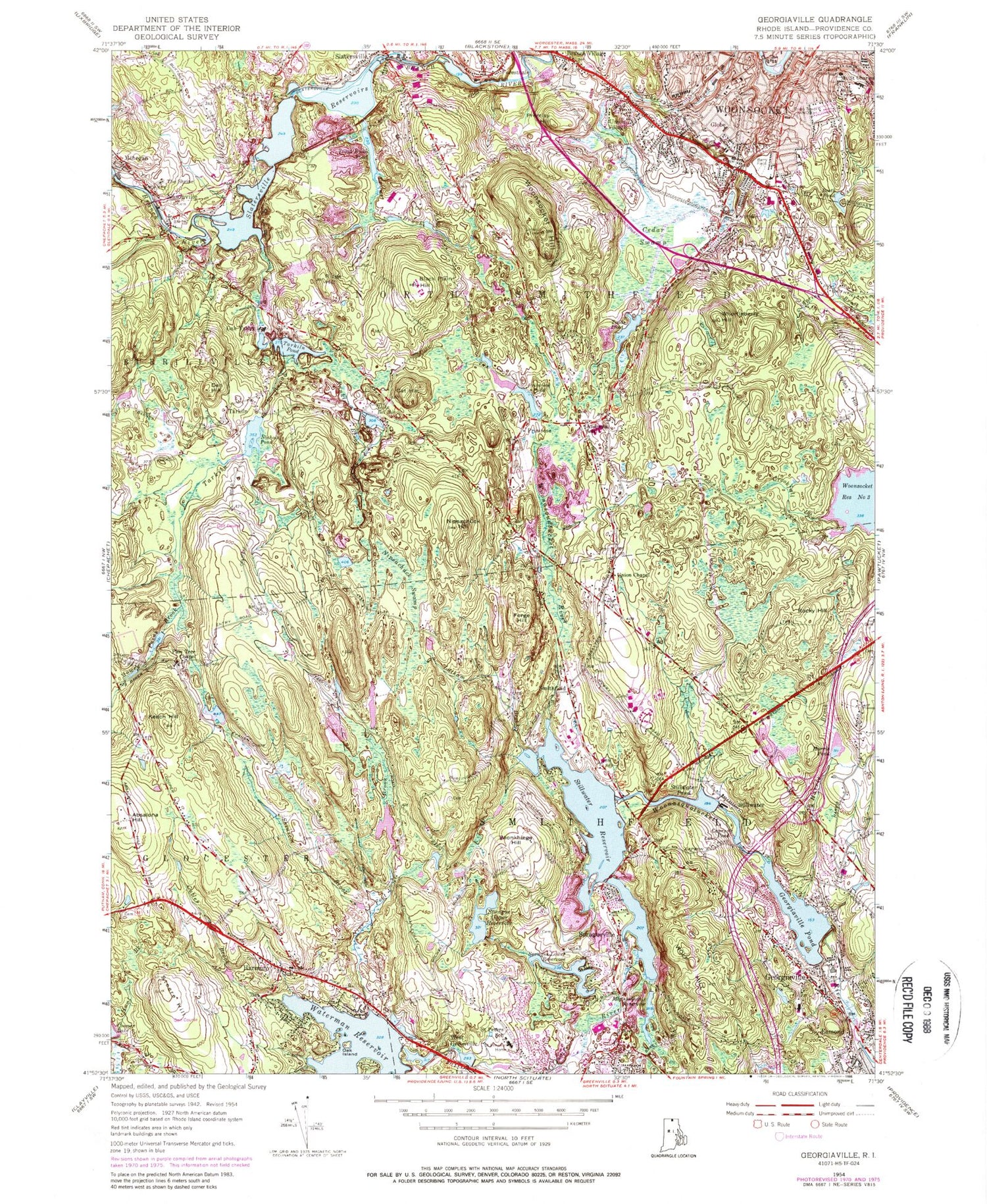
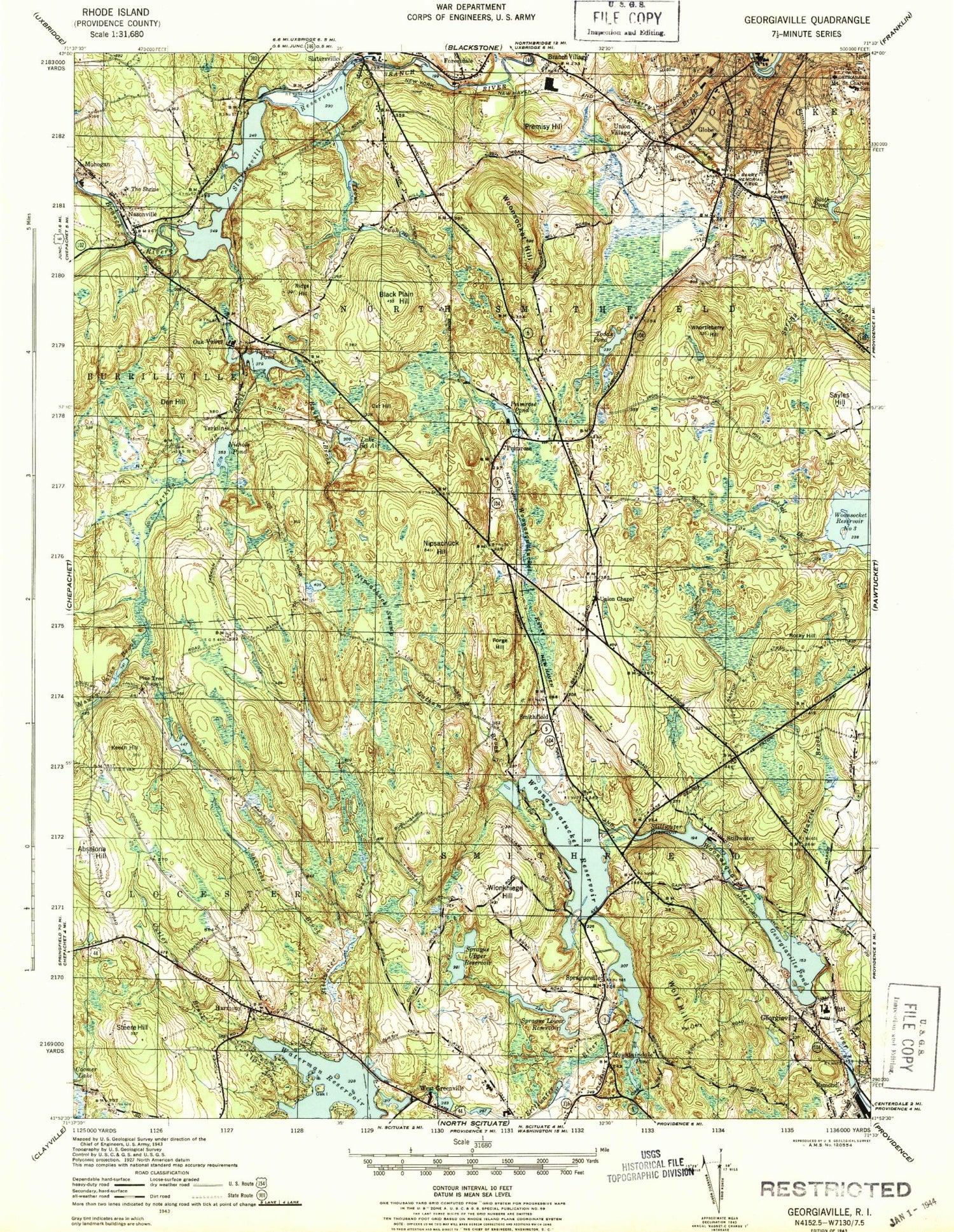
MyTopo
Classic USGS Georgiaville Rhode Island 7.5'x7.5' Topo Map
Couldn't load pickup availability
Historical USGS topographic quad map of Georgiaville in the state of Rhode Island. Typical map scale is 1:24,000, but may vary for certain years, if available. Print size: 24" x 27"
This quadrangle is in the following counties: Providence.
The map contains contour lines, roads, rivers, towns, and lakes. Printed on high-quality waterproof paper with UV fade-resistant inks, and shipped rolled.
Contains the following named places: Dawley Brook, Steere Hill, Cutler Brook, Oak Island, Waterman Reservoir, Nine Foot Brook, Sprague Upper Reservoir, Sprague Lower Reservoir, Spragueville, Mountaindale Reservoir, Reaper Brook, Wolf Hill, Georgiaville, Georgiaville Pond, Capron Pond, Stillwater Pond, Wionkhiege Hill, Shinscot Brook, Absalona Hill, Keech Hill, Latham Brook, Stillwater River, Stillwater Reservoir, Harris Pond, Rocky Hill, Forge Hill, Nipsachuck Hill, Nipsachuck Swamp, Mowry Paine Brook, Nichols Pond, Lake Bel Air, Sayles Hill, Whortleberry Hill, Todds Pond, Cat Hill, Black Plain Hill, Ridge Hill, Rankin Brook, Tarkiln Brook, Tarkiln Pond, Trout Brook, Trout Brook Pond, Woonsocket Hill, Premisy Hill, Cedar Swamp, Booth Pond, Branch Village, Forestdale, Slatersville Reservoirs, Den Hill, Hunt Brook, Harris Brook, Primrose Pond, The Shrine, Coomer Lake, Waterman Reservoir Dam, Mountaindale Reservoir Dam, Sprague Lower Reservoir Dam, Georgiaville Pond Dam, Upper Sprague Reservoir, Upper Sprague Reservoir Dam, Curran Lower Reservoir, Curran Lower Reservoir Dam, Stillwater Pond Dam, Stillwater Reservoir Dam, Primrose Pond Dam, Nichols Pond Dam, Tarkiln Pond Dam, Slatersville Reservoir Upper Dam, Forestdale Pond, Forestdale Pond Dam, Slattersville Reservoir, Slatersville Reservoir Middle Dam, North Smithfield, Oak Valley, Mountaindale, Boiling Spring, Field Station (historical), Harmony, West Greenville, Stillwater, Smithfield, Tarkiln, Globe, Oak Valley, Mohegan, Nasonville, Union Village, Primrose, WJMF-FM (Smithfield), WWON-FM (Woonsocket), WLKW-AM (Providence), WWON-AM (Woonsocket), Town of North Smithfield, Town of Smithfield, Allenville Mill (historical), Andrews School, Anna M McCabe School, Apostolic Pentecostal Church, Apple Valley, Barry Field, Berean Baptist Church, Bernon Heights School, The Blunders, Bryant College, Capron Memorial Bridge, Fifth Avenue School, Smithfield Fire Department Station 3, Forestdale Mill Village Historic District, Forestdale Post Office, Friends Meeting House (historical), Georgiaville Baptist Church, Georgiaville Beach, Smithfield Fire Department Station 2, Globe Park, Globe Park School, Gloucester Country Club, Greenville Shopping Center, Grove Street School, Hanora Mills, Harmony Cemetery, Harmony Chapel, Harmony Post Office, Harrisville Pre-School, Holy Family Church, Irving S Cook School, Island Place Historic District, Kevin K Coleman Elementary School, Market Square, Melody Hill Golf Course, Monsignor Gadoury Regional Primary School, Mount Saint Charles School, Mountaindale Beach, Museum of Work and Culture, North Smithfield Elementary School, North Smithfield Junior-Senior High School, North Smithfield Wildlife Marsh, North Smithfield Town Hall, Old Country Road School, Our Redeemer Lutheran Church, Park Square Plaza Shopping Center, Pine Tree Chapel, River Island Park, Saint Aloysius Home, Saint Francis Orphanage, Saint Peters School, Slatersville Plaza Shopping Center, Slatersville Post Office, Smith-Appleby House, Smithfield Senior High School, Smithfield Town Hall, South Main Street Historic District, Steers Beach, Trout Brook Horse Farm, Union Cemetery, Union Chapel, Union Village Historic District, Universalist Church (historical), Upper Slatersville Reservoir, Woonsocket Falls, Georgiaville Historic District, Greenville Census Designated Place, Landmark Medical Center Fogarty Campus, Breezy Knoll Child Care Center, Bryant College Library, Child Care Connection of Smithfield, Fairmount Branch Library, Harmony Fire Department, Harmony Library, Just For Kids Day Care, Kittens and Cubs Day Care Center, Nasonville Fire Department, North Smithfield Fire Station 2 Headquarters, North Smithfield Police Department, North Smithfield Public Library, Northwest Health Center, Park Square Childrens Center, Peleg Arnold Tavern, Pleasant View Day Care Center, Smithfield Police Department, Smithfield Post Office, Bourdon Boulevard Center Woonsocket Head Start, Burrillville Middle School, Masters Regional Academy, Raymond C LaPerche School, Slatersville Preschool, Vincent J Gallagher Middle School, Jaswells Farm, Matteo's Farm, Steere Orchard, Seven Cedars Christmas Tree Farm, Gould Brook, Whipple Brook, Airport Creek, Hanton Brook, Mattetokomitt Swamp, Mattetee Swamp Brook, Sprague Brook, Logee Hill, Harmony Census Designated Place, Woonsocket Fire Department Station 1, Rehabilitation Hospital of Rhode Island, Barnes - Smith Lot Cemetery, Otis Bligh Lot, Captain John Smith Lot, Saint Theresa's Cemetery, Nelson Payne Lot Cemetery, Joseph Farnum Lot Cemetery, Elisha Steere Lot Cemetery, Joseph Mowry Lot Cemetery, Richard Sweet Lot Cemetery, Albert Windsor Lot, Stephen Steere Lot Cemetery, Colonel Abraham Winsor Lot Cemetery, William Enches Lot Cemetery, David Mowry Lot Cemetery, Obadiah Smith Lot Cemetery, Mowry Turner Lot Cemetery, Arnold - Vose Cemetery, Stephen Mowry Lot, Mowry - Hall Lot, Saint John's Cemetery, Isreal Aldrich Lot, Joseph Inman Lot, Jashub Wing Lot, Elijah Smith Lot, Smith Lot, Ananias Mowry Lot, Richard Mowry Lot, Old Aldrich Burial Grounds, Old Town Burial Ground, Sterry Young Lot, Enoch Steere Lot, Pardon Hunt Lot, John Colwell Lot, William Coman Lot