MyTopo
Classic USGS Germantown Maryland 7.5'x7.5' Topo Map
Couldn't load pickup availability
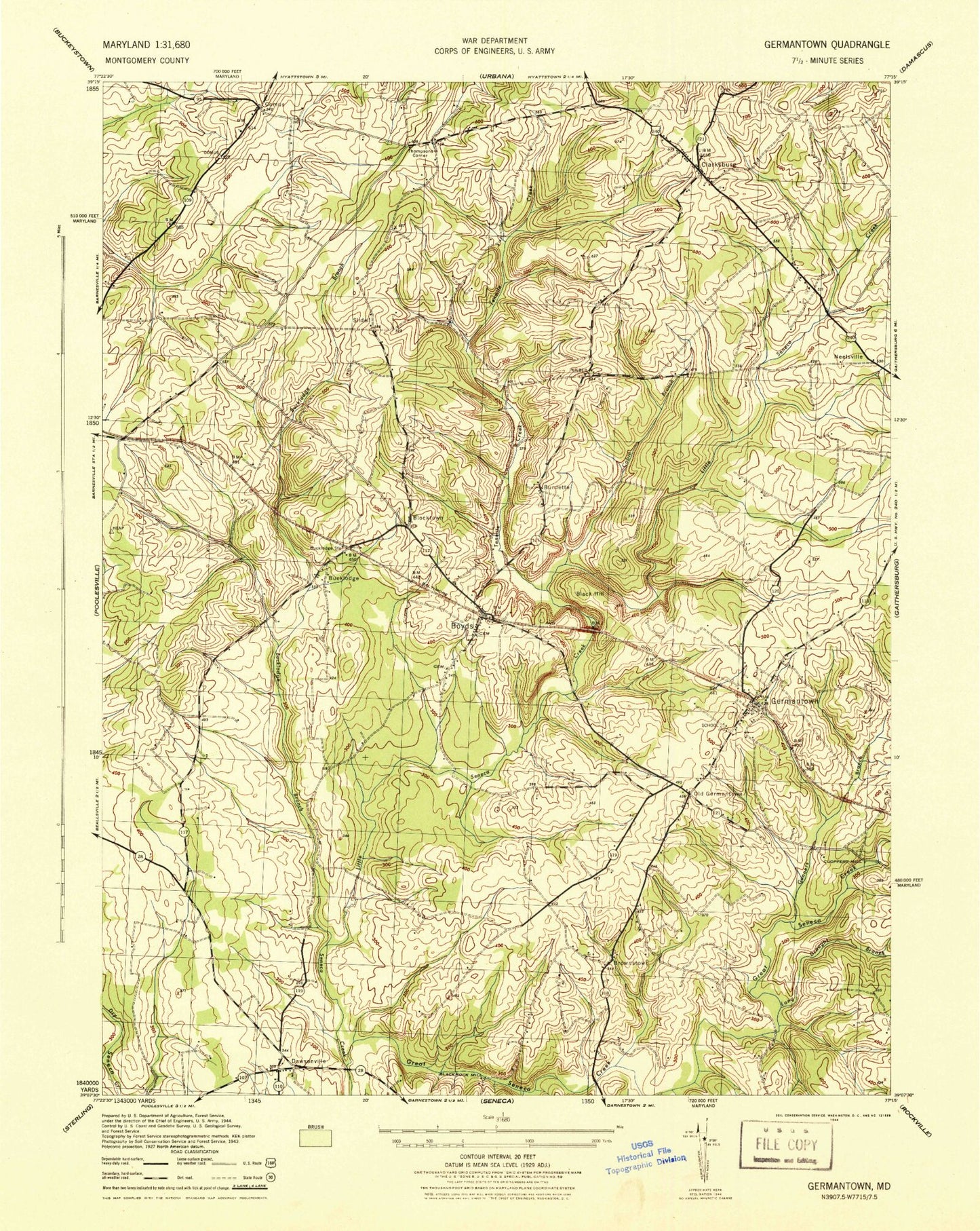
Historical USGS topographic quad map of Germantown in the state of Maryland. Typical map scale is 1:24,000, but may vary for certain years, if available. Print size: 24" x 27"
This quadrangle is in the following counties: Montgomery.
The map contains contour lines, roads, rivers, towns, and lakes. Printed on high-quality waterproof paper with UV fade-resistant inks, and shipped rolled.
Contains the following named places: Blocktown, Boyds, Brownstown, Bucklodge Branch, Cabin Branch, Clarksburg, Clarksburg Elementary School, Germantown, Germantown Elementary School, Great Seneca Creek, Gunners Branch, John Wesley Church, Little Seneca Creek, Long Draught Branch, Saint Marks Church, Taylor School, Tenmile Creek, Little Seneca Lake, Bucklodge, Comus, Old Germantown, Slidell, Thompsons Corner, Black Hill, Blackrock Mill, Burdette, Dawsonville, Germantown Golf Course, Dawsonville Mennonite Church, Germantown Baptist Church, Barnesville Baptist Church, Boyds Presbyterian Church, Messiah Lutheran Church, Greenridge Baptist Church, Mother Seton Catholic Church, Trinity United Methodist Church, Area 3 School Administration Center, WSSC Pumping Station, Clarksburg Methodist Church, Boyds Railroad Station, Germantown Railroad Station, Middlebrook Technical Park, Gateway 270 Business Center, Northlake Commerce Center, 270 Corporate Center, Germantown Technical Center, Clarksburg Community Center, Asbury United Methodist Cemetery, Boyds Presbyterian Church Cemetery, Saint Marks United Methodist Church Cemetery, Germantown Square Shopping Center, Germantown Library, Asbury United Methodist Church, Churchill Town Sector Dam, Lake Churchill, Boyds Post Office, WGMS-AM (Bethesda), Bucklodge Station, Cloppers Mill, Waring (historical), Barnesville School, Beau Monde Estates, Black Hill, Blackrock Estates, Blackrock Hills, Brownstown Estates, Cedar Creek Estates, Church of God, Clarksbrook Estates, Clarksburg Heights, Clarksburg Post Office, Clopper Lake, Clopper Mill Elementary School, Dawsonville Regional Park, Farmingdale Estates, Fountain View, Garnkirk Farms, Germantown Commons Shopping Center, Germantown Estates, Germantown Estates Park, Germantown Park, Germantown Post Office, Germantown View, Gunners Branch Park, Gunners Lake Park, Kings Park, Kingsview Knolls, Lees Corner, Liberty Heights, Little Seneca Regional Park, Meadowbrook Estates, Miles Corner, Oak Ridge, Old Germantown Park, Pleasant Fields, Quince Orchard Manor, Quince Orchard Valley, Quince Orchard Valley Park, Ronald McNair Elementary School, Running Brook Acres, S Christa McAuliffe Elementary School, Seneca Valley High School, South Germantown Greenbelt Park, South Gunners Branch Park, Stoneridge, The Colony, Waters Landing Elementary School, Wilber, Williamsburg Square, Greenridge Acres, Lake Seneca Elementary School, North Germantown, District 11, District 2, Spark M Matsunaga Elementary School, Kingsview Middle School, Rocky Hill Middle School, Northwest High School, Jessup Volunteer Fire Department, Montgomery County Sheriffs Department, Montgomery County Police Department - Germantown District, Germantown Volunteer Fire Department - Station 29, Doctor Martin Luther King Junior Middle School, Great Seneca Creek Elementary School, Little Bennett Elementary School, Spark M Matsunaga Elementary School, Thurgood Marshall Elementary School, Elf Early Learning Fun School, Academy of the Child, Clarksburg High School, Kingsley Wilderness Project, Clarksburg Census Designated Place, Germantown Census Designated Place, Fly Away Farm Airport, Montgomery County Correctional Facility, Germantown Fire Station Company 29, Germantown Police Station, Cedar Brook Community Church, Montgomery County Fire Rescue Station 35 - Clarksburg, Redeeming River Church Germantown Campus, Maryland - National Capital Park Police Facility - Black Hill Regional Park, Ten Mile Creek Census Designated Place