MyTopo
Classic USGS Gibson Island Maryland 7.5'x7.5' Topo Map
Couldn't load pickup availability
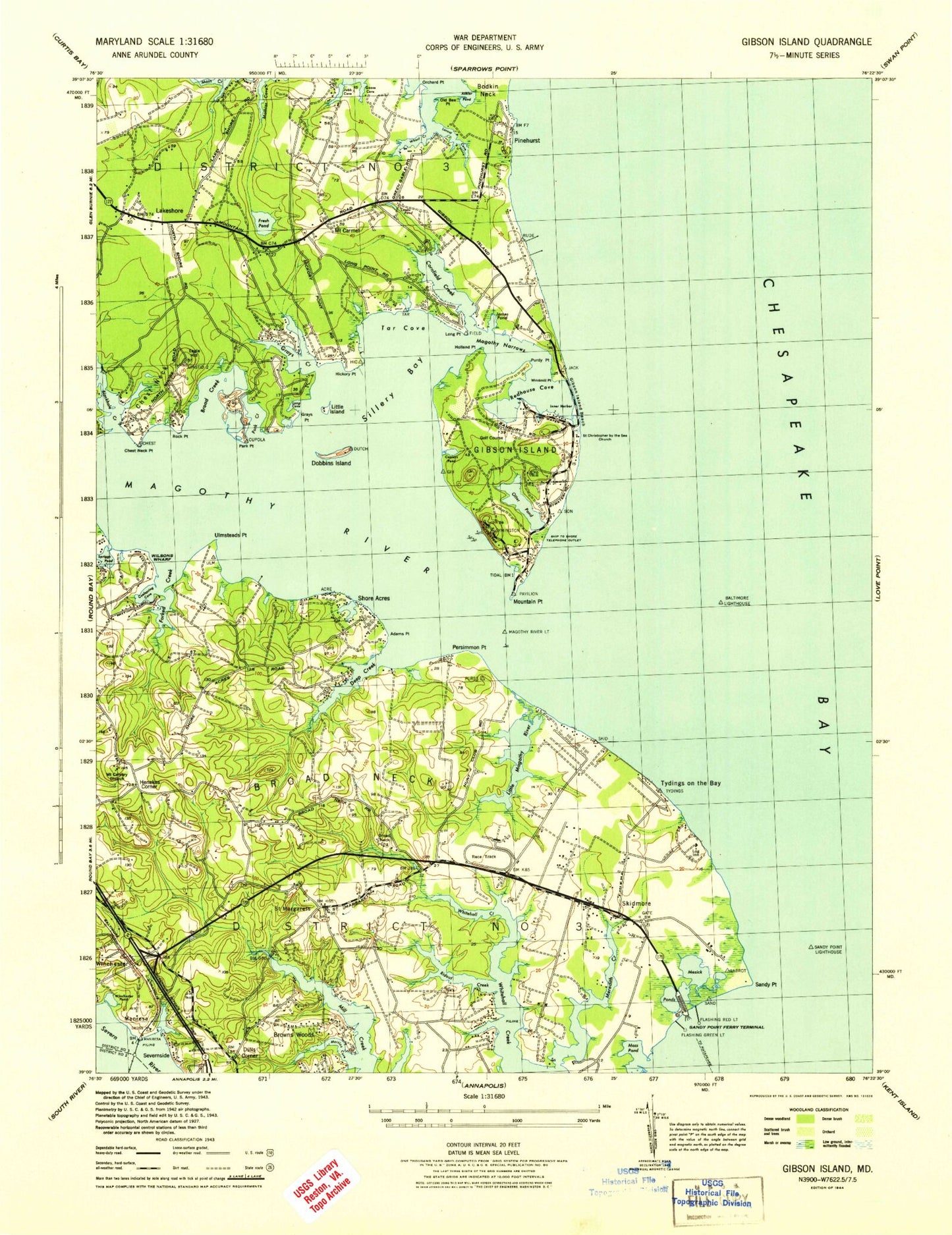
Historical USGS topographic quad map of Gibson Island in the state of Maryland. Typical map scale is 1:24,000, but may vary for certain years, if available. Print size: 24" x 27"
This quadrangle is in the following counties: Anne Arundel.
The map contains contour lines, roads, rivers, towns, and lakes. Printed on high-quality waterproof paper with UV fade-resistant inks, and shipped rolled.
Contains the following named places: Adams Point, Ashlar Pond, Baltimore Lighthouse, Blackhole Creek, Broad Creek, Broad Neck, Asbury Broadneck United Methodist Church, Chesapeake Bay Institute Field Laboratory Jo, Chest Neck, Chest Neck Point, Cooks Pond, Cool Spring Cove, Cooleys Pond, Cornfield Creek, Deep Creek, Dobbins Island, Eagle Hill, Forked Creek, Fresh Pond, Gibson Island, Gibson Island Beach, Goose Cove, Grays Creek, Grays Point, Henekes Corner, Hickory Point, Holland Point, Hunters Harbor, James Pond, Jubb Cove, Little Island, Little Magothy River, Locust Cove, Long Cove, Long Point, Magothy Narrows, Magothy River, Magothy River Light, Martins Cove, Mathias Cove, Mezick Ponds, Moss Pond, Mount Calvary United Methodist Church, Mountain Point, Old Bee Point, Orchard Point, Otter Pond, Park Creek, Park Point, Persimmon Point, Purdy Point, Redhouse Cove, Ridout Creek, Rock Point, Saint Christopher by the Sea Church, Saint Margarets, Sandy Point, Sandy Point Lighthouse, Sandy Point State Park, Sillery Bay, Spriggs Pond, Tar Cove, Ulmstead Point, Wharf Creek, Wilsons Wharf, Winchester Pond, Windmill Point, Scheides Cove, Shorts Creek, Podickory Creek, Podickory Point, Dulls Corner, Meredith Creek, Log Inn, Belvidere Shoal, Craighill Channel, Bayberry, Beacon Hill, Browns Woods, Cape Saint Claire, Eagle Hill, Gibson Island, Lake Shore, Manresa, Mount Carmel, Pinehurst, Severnside, Shore Acres, Skidmore, Tydings on the Bay, Winchester, Minnow Creek, C W Martin Heliport, Mountain Road Airport, Amberly, Bay Manor Nursing Home, Bayhead, Beacon View, Cape Saint Claire Elementary School, Cape Saint Claire Recreation Area, Chesapeake Oaks, Homewood Cove, Meredith Homes, Pettebone Farms, Pleasant Plains, Podickory Point, Revell Downs, Saint Margarets Episcopal Church Cemetery, Saint Margarets Episcopal Church, Saint Margaret Medical Center, Sandy Point Ferry Terminal (historical), Stinchcomb-Tydings Cemetery, Westinghouse Bay, Whitehall Beach, Whitehall Estates, Whitehall Manor, Whitehall Shopping Center, Woods Landing, Yorktown, Holly Anna Acres, Admirals Walk, Antioch Church, Arcadia, Arnold Park, Atlantis, Bay Hills, Bay Hills Country Club, Bellerive Village, Belvedere Yacht Club, Bodkin Elementary School, Boulevard Park, Briar Lea, Briarwood, Brice Manor, Broad Neck Branch Library, Broadneck Elementary School, Broadneck High School, Broad Neck Medical Center, Broadneck Park, Broadwater Beach, Browns Woods Villa, Cape Saint Claire United Methodist Church, Capetowne, Captains Choice, Cedarwood Cove, Cedarwood Cove Cemetery, Cherrywood, Chesapeake Bay Middle School, Chesapeake High School, Chesapeake Montessori School, Christ Our Anchor United Presbyterian Church, Church of Christ, College Parkway Shopping Center, Colonial Manor Trailer Park, Deer Creek, Dorado Hills, Dorado Village, Downs Memorial Park, Forest Meadows, Foxmoor, Galilee Lutheran Church, Gibson Island Country School, Gibson Island Golf Course, Gibson Island Post Office, Gibson Island Yacht Club, Gloria Dei Lutheran Church, Great Meadows, Green Gables, Greenholly, Herons Watch, Hidden Ridge, Hollyberry Woods, Hunters Harbor, Indian Hills, Kimberly Woods Village, Lake Shore Elementary School, Lake Shore Recreation Area, Landhaven, Long Point, Longview, Martins Cove Farm, Mount Carmel Cemetery, Mount Carmel United Methodist Church, North Shore, Northport, Oakland Hill, Oakmont, Old Mill Bottom Estates, Pinehurst on the Bodkin, Lake Placid, Point-O-Woods, Saint Andrew by the Bay Catholic Church, Saint Johns Woods, Saint Margarets Farm, Shirleyville, Sillery Bay, Sillery Bay Forest, Sillman Estates, Stonington, Sturbridge, Sylvan View, Tanglewood, Tate Landing, The Meadows, Manresa Pond, Tree Tops, Ulmstead Acres, Ulmstead Cove, Ulmstead Estates, Ulmstead Gardens, Ulmstead Point, Ventnor, Ventnor Forest, Walnut Ridge, Weatherly, Whispering Woods, Windsor Farm Elementary School, Bell Forest, Bodkin Plains, Fairwood, Kingston Estates, Lake Shore Baptist Church, Long Point on the Magothy, Lyndale, Lynwood Village, Milburn on the Magothy, Mountain Wood, Riding Woods, Saybrooke, Windermere Estates, District 5, Bohdal Pond, Inner Harbor, Blackhole Creek Bog, Dobbins Pond, Eagle Hill Bog