MyTopo
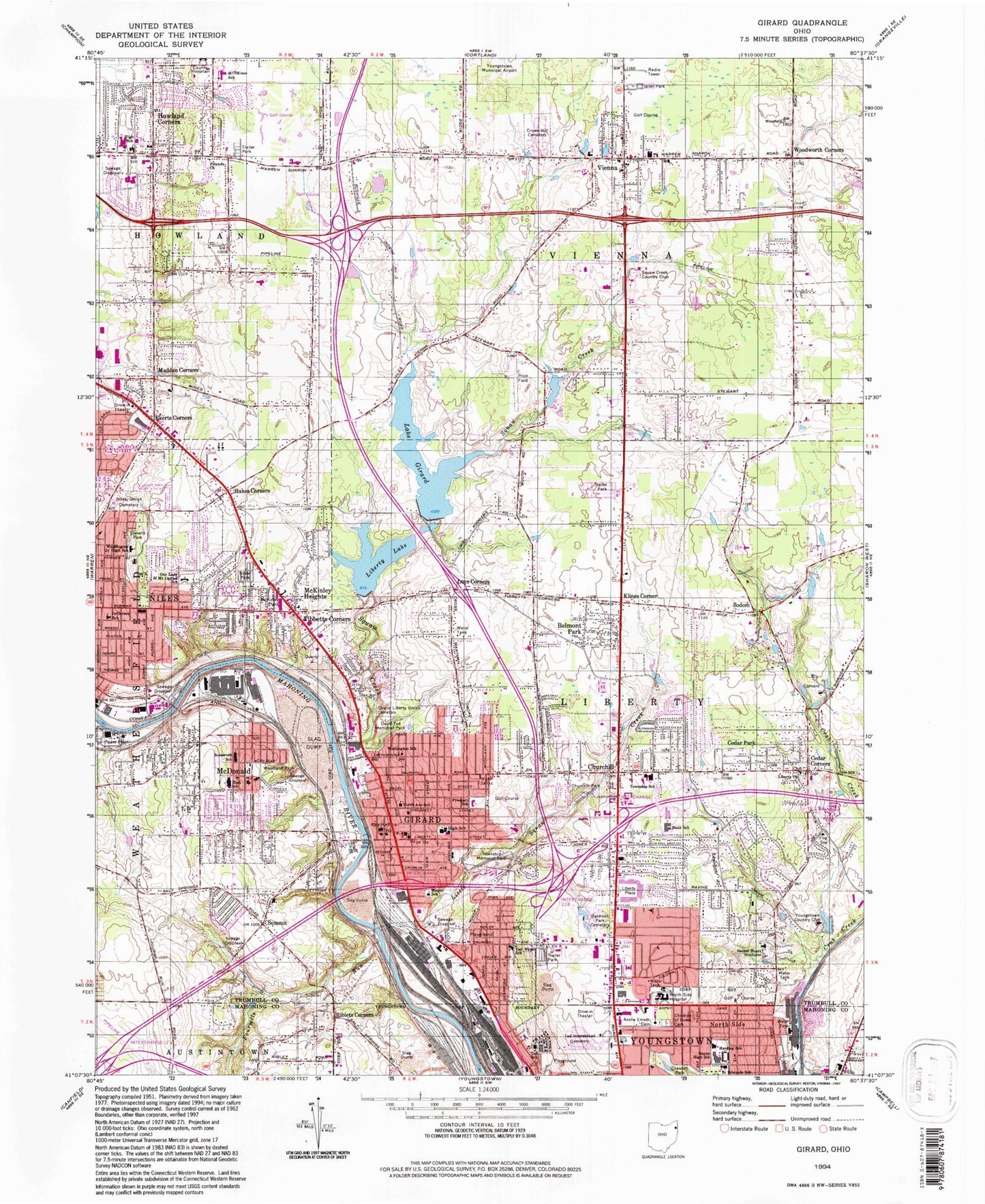
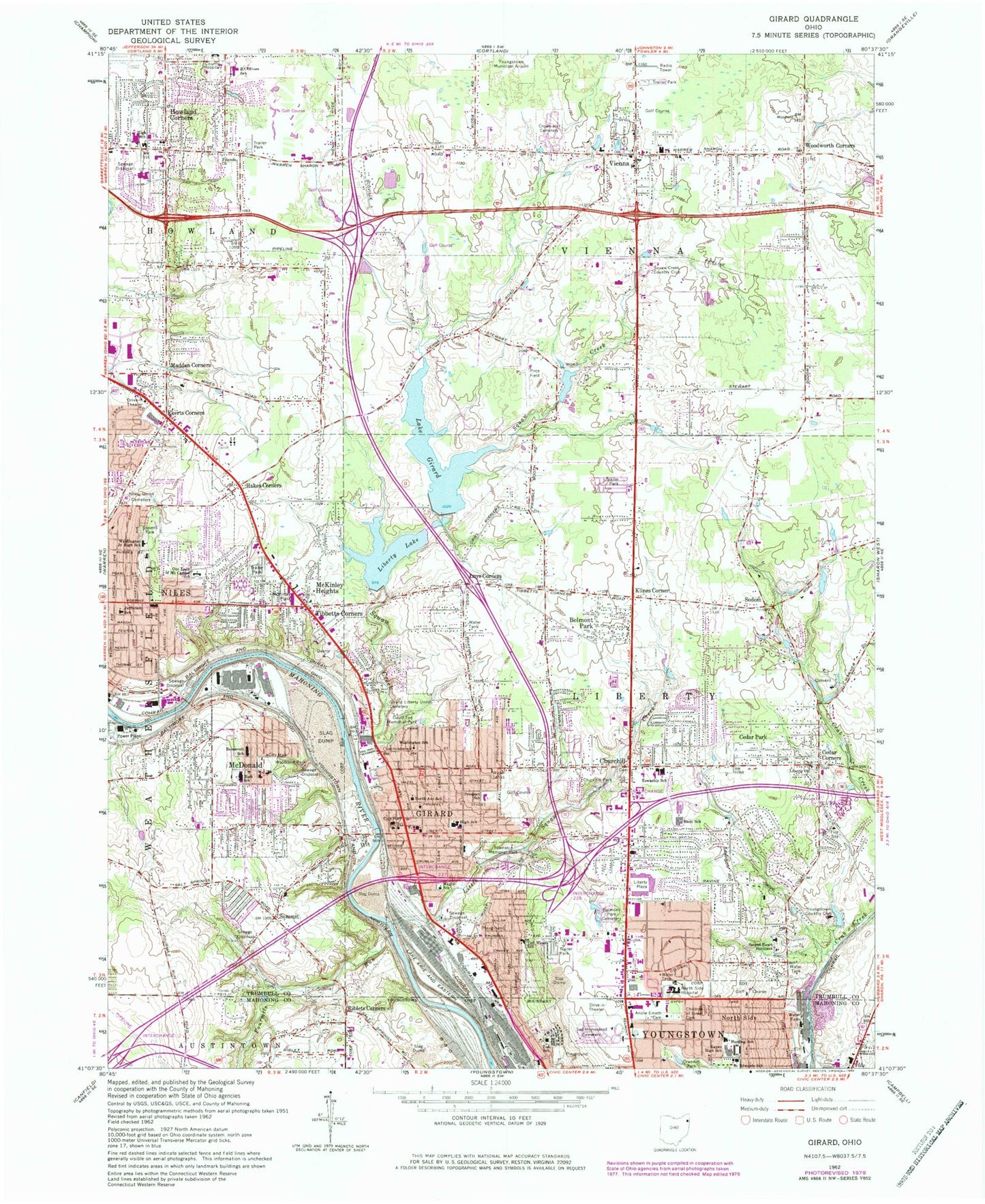
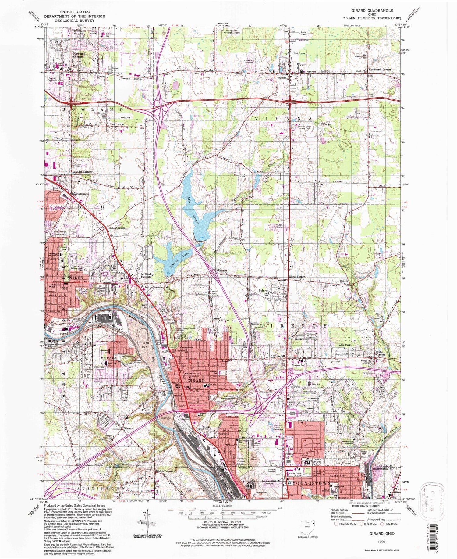
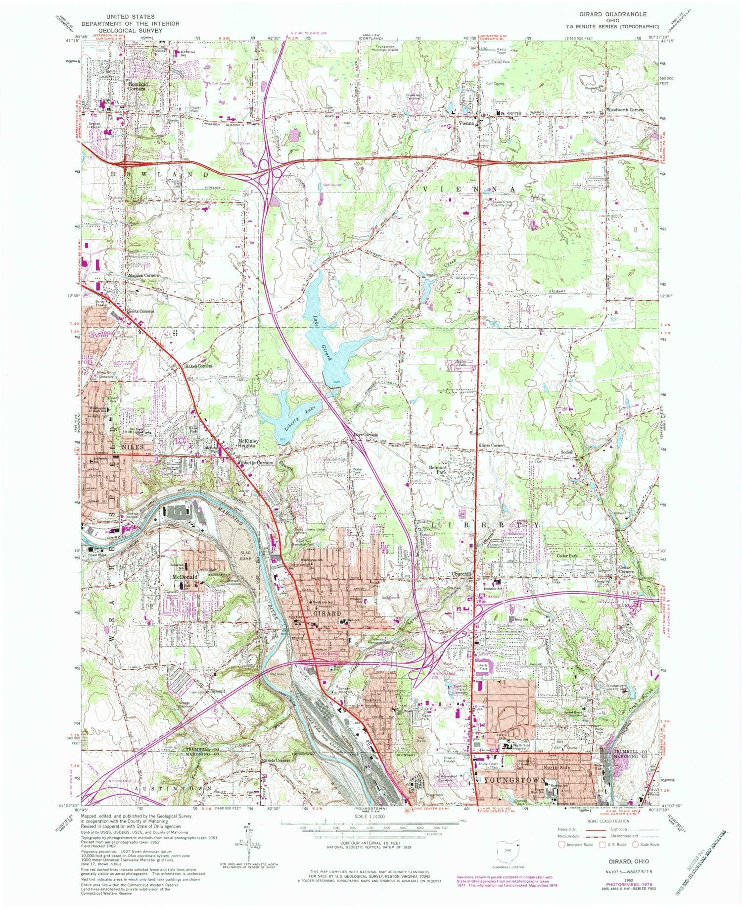
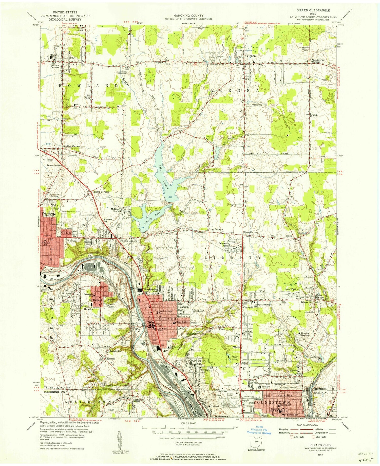
Classic USGS Girard Ohio 7.5'x7.5' Topo Map
Couldn't load pickup availability
Historical USGS topographic quad map of Girard in the state of Ohio. Map scale may vary for some years, but is generally around 1:24,000. Print size is approximately 24" x 27"
This quadrangle is in the following counties: Mahoning, Trumbull.
The map contains contour lines, roads, rivers, towns, and lakes. Printed on high-quality waterproof paper with UV fade-resistant inks, and shipped rolled.
Contains the following named places: Anshe Emeth Cemetery, Apostolic Christian Church, Avalon Golf Course, Baker Elementary School, Bel Air Mobile Home Park, Belmont Park, Belmont Park Cemetery, Belmont Pines Hospital, Belmont Plaza Shopping Center, Beth Yeshua Congregation, Block School, Candywood Golf Course, Cedar Corners, Cedar Park, Children of Israel Cemetery, Church Hill Cemetery, Church Hill United Methodist Church, Churchill, Churchill Census Designated Place, Churchill Park, Churchill Post Office, City of Girard, Crandal Park-Fifth Avenue Historic District, Crown Hill Cemetery, David Tod Memorial Park, Dunlap Cemetery, E J Blott Elementary School, Ekerts Corners, Fairview United Methodist Church, Faith Temple Apostolic Church, First Assembly of God Church, First Baptist Church of Girard, First Baptist Church of McDonald, First Christian Assembly Church, First Christian Church of Girard, First Presbyterian Church of Girard, First Presbyterian Church of Niles, First United Methodist Church of Girard, First United Methodist Church of Niles, Fourmile Run, Friends Church, Friendship Baptist Church, Girard, Girard Church of Christ, Girard Fire Department, Girard Free Public Library, Girard High School, Girard Liberty Union Cemetery, Girard Mini-Mall Shopping Center, Girard Police Department, Girard Post Office, Great East Plaza Shopping Center, Grimms Mobile Home Park, Guthiel Ditch, Hakes Corners, Halls Corners, Harding Elementary School, Hillcrest Trailer Court, Hilltop, Hilltop Census Designated Place, Hope Baptist Church, Howland Center Census Designated Place, Howland Corners, Howland High School, Howland Middle School, Howland Mobile Home Park, Howland Springs Elementary School, Howland Township Fire Department Station 30, Howland Township Police Department, Immanuel Lutheran Church, Jamesplace Plaza Shopping Center, Jefferson Elementary School, Klines Corner, Lake Girard Dam, Liberty Church, Liberty High School, Liberty Lake Dam, Liberty Plaza Shopping Center, Liberty Square Plaza Shopping Center, Liberty Township Fire Department Station 2, Liberty Township Fire Department Station 35, Liberty Township Police Department, Little Squaw Creek, Lower Girard Lake, Loy School, Loys Corners, Madden Corners, Mahoning Country Club, Mahoning Golf Course, Maple School, Mathews High School, McDonald, McDonald Fire Department, McDonald High School, McDonald Plaza Shopping Center, Mcdonald Police Department, McDonald Post Office, McKinley Heights, McKinley Heights Census Designated Place, Midway Mobile Home Park, Mines Elementary School, Murray School, New Life Lutheran Church, Niles Generating Station, Niles Union Cemetery, Niles Wesleyan Methodist Church, North Avenue School, Northeast Ohio Correctional Center, Northside Baptist Church, Northside Medical Center, Our Lady of Mount Carmel School, Our Lady of Perpetual Help Catholic Church, Our Lady of Sorrows Church, Paul's Trailer Park, Pine Tree Place Shopping Center, Price Field, Prospect Junior High School, Rayen High School, Riblets Corners, Romar Plaza Shopping Center, Roosevelt Elementary School, Sacred Heart Novitiate, Saint Edwards Catholic Church, Saint Johns Byzantine Catholic Church, Saint Mark Orthodox Church, Saint Roccos Episcopal Church, Saint Rose Catholic Church, Saint Rose School, Saint Vincent De Paul Catholic Church, Seceders Corners Cemetery, Shield of Faith Ministries Center, Smith-Stewart Field, Sodom, Sodom Post Office, Squaw Creek, Squaw Creek Country Club, Squaw Valley Park Lake, Squaw Valley Park Lake Dam, Stambaugh Golf Course, Stevens Park, Suburban Mobile Home Park, Summit, Summit Assembly of God Church, Summit Elementary School, Ted Wood School, The Village Center Shopping Center, Tibbetts Corners, Tod Field, Tod Homestead Cemetery, Tod School, Township of Liberty, Township of Vienna, Trinity Evangelical Lutheran Church, Trinity Lutheran Church, Union Square Shopping Center, Upper Girard Lake, Vienna, Vienna Center Cemetery, Vienna Center Census Designated Place, Vienna Fire Department, Vienna Post Office, Vienna United Methodist Church, Village of McDonald, Washington Elementary School, Washington Junior High School, Weathersfield Township Fire Department Station 40, Welsh Hill Cemetery, Wesleyan Methodist Church, William S Guy Middle School, Wilson Avenue Public School, Woodland Park, Woodland Park United Methodist Church, Woodworth Corners, Youngstown Country Club, Youngstown Development Center Heliport, ZIP Codes: 44420, 44437, 44446