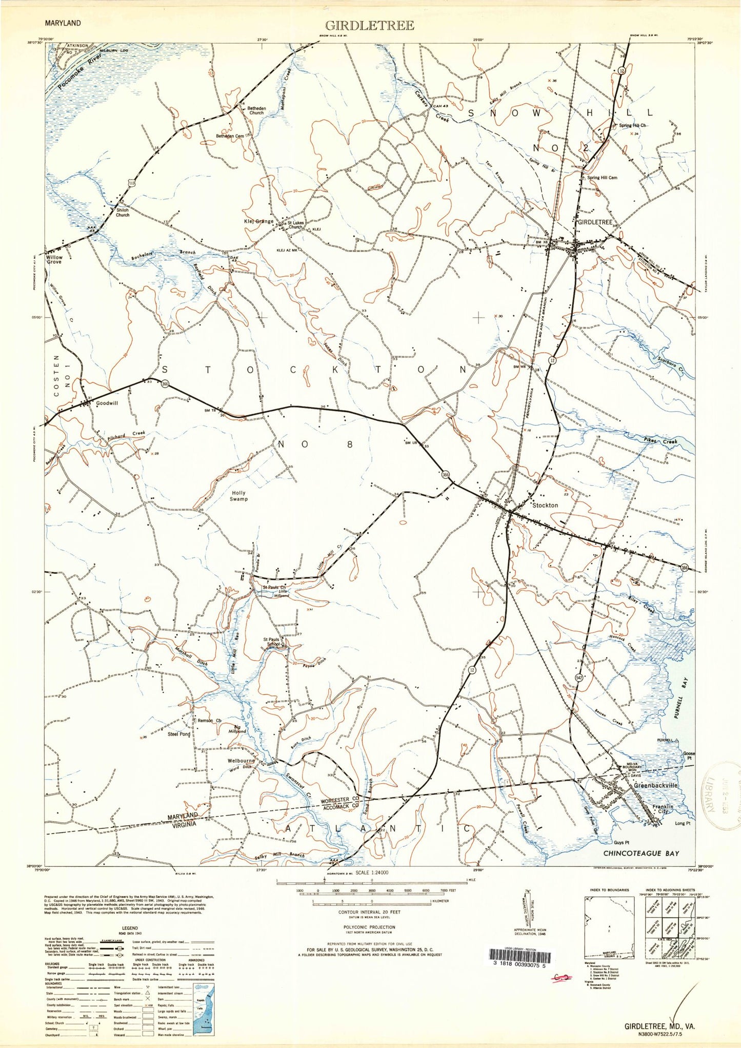
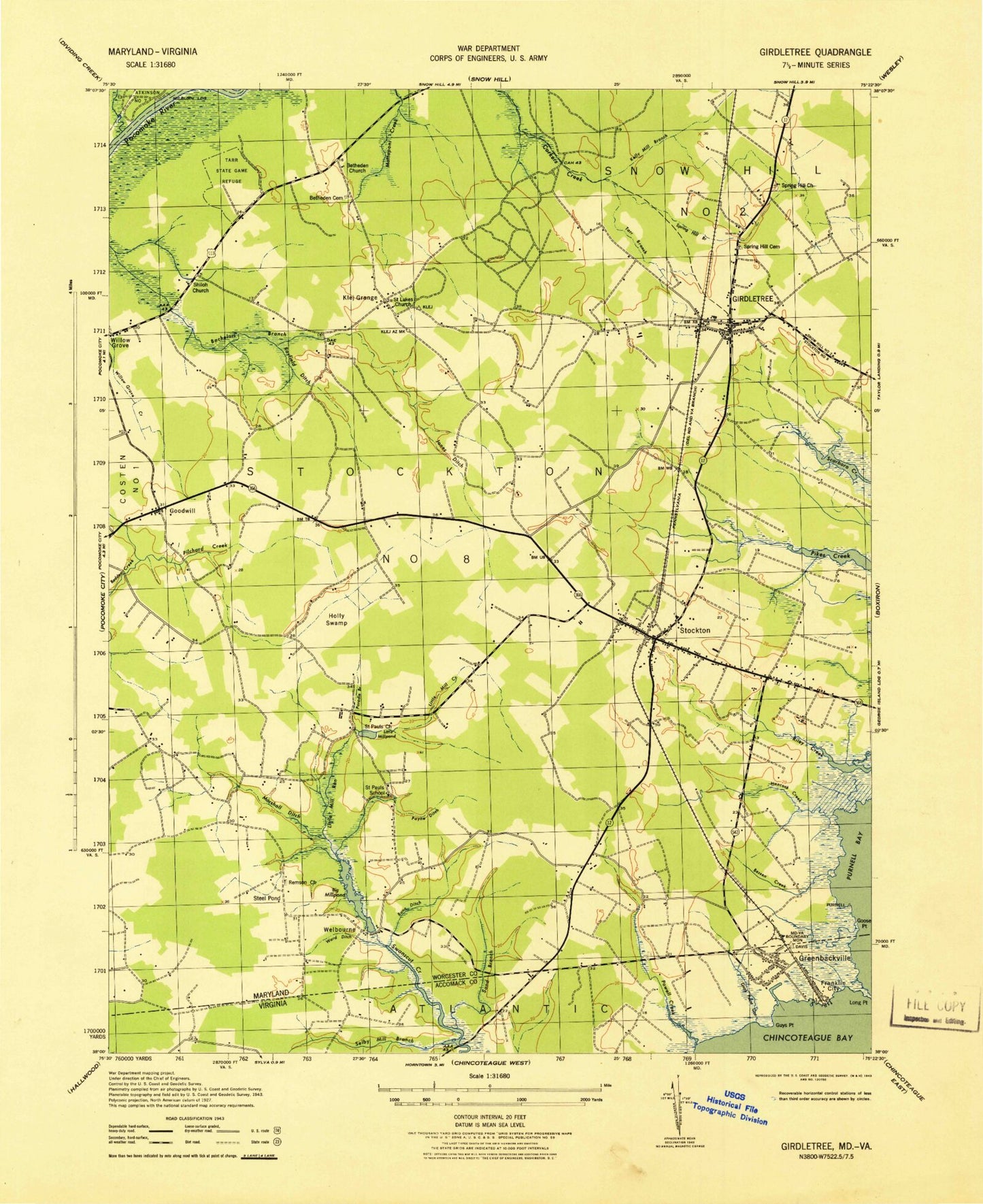
MyTopo
Classic USGS Girdletree Maryland 7.5'x7.5' Topo Map
Couldn't load pickup availability
Historical USGS topographic quad map of Girdletree in the states of Maryland, Virginia. Map scale may vary for some years, but is generally around 1:24,000. Print size is approximately 24" x 27"
This quadrangle is in the following counties: Accomack, Worcester.
The map contains contour lines, roads, rivers, towns, and lakes. Printed on high-quality waterproof paper with UV fade-resistant inks, and shipped rolled.
Contains the following named places: Bessen Creek, Bessen Landing, Beth Eden Cemetery, Betheden Church, Big Mill, Big Millpond, Big Millpond Dam, Bunn Ditch, Captains Cove Census Designated Place, Church Street Cemetery, Church Street School, Cool Spring Cemetery, Cool Spring Church, Cottingham Mill Run, District 1 Southern, District 8 Stockton, Episcopal Chapel of the Holy Cross, Franklin City, Girdletree, Girdletree Census Designated Place, Girdletree Post Office, Girdletree Volunteer Fire Company - Station 300, Goodwill, Goodwill Baptist Church, Goodwill Ditch, Goodwill Methodist Cemetery, Goose Point, Goose Point Marsh, Greenbackville, Greenbackville Census Designated Place, Greenbackville Post Office, Greenbackville Volunteer Fire Department, Gunby Memorial Presbyterian Church, Gunby Methodist Cemetery, Guys Point, Guys Point Gut, Hancock Cemetery, Hancock Creek, Holly Swamp, Jones Ditch, Kelly Mill Branch, Klej Grange, Little Mill Creek, Little Mill Run, Little Millpond, Little Red School, Long Point, Marshall Ditch, Marshall Mill Run, Milburn Landing, Mount Hope Baptist Cemetery, Mount Hope Church, Old Shiloh Cemetery, Owl Hollow Acres, Paradie Branch, Payne Ditch, Portersville Cemetery, Portersville Church, Powell Creek, Rayfield Ditch, Redden Creek, Remson Church, Remson Methodist Cemetery, Saint Lukes Cemetery, Saint Lukes Church, Saint Marks Cemetery, Saint Marks Church, Saint Pauls Church, Saint Pauls School, Sand Branch, Selby Mill Branch, Shiloh Cemetery, Shiloh Church, Snider Dam, Spring Hill Branch, Spring Hill Cemetery, Steel Pond, Stockton, Stockton Census Designated Place, Stockton Post Office, Stockton Volunteer Fire Company - Station 200, Tarr Branch, Union Franklin City Cemetery, Union Greenbackville Cemetery, Vaughn State Wildlife Management Area, Ward Ditch, Welbourne, Wesley Cemetery, Wesley Church, ZIP Code: 21864