
MyTopo
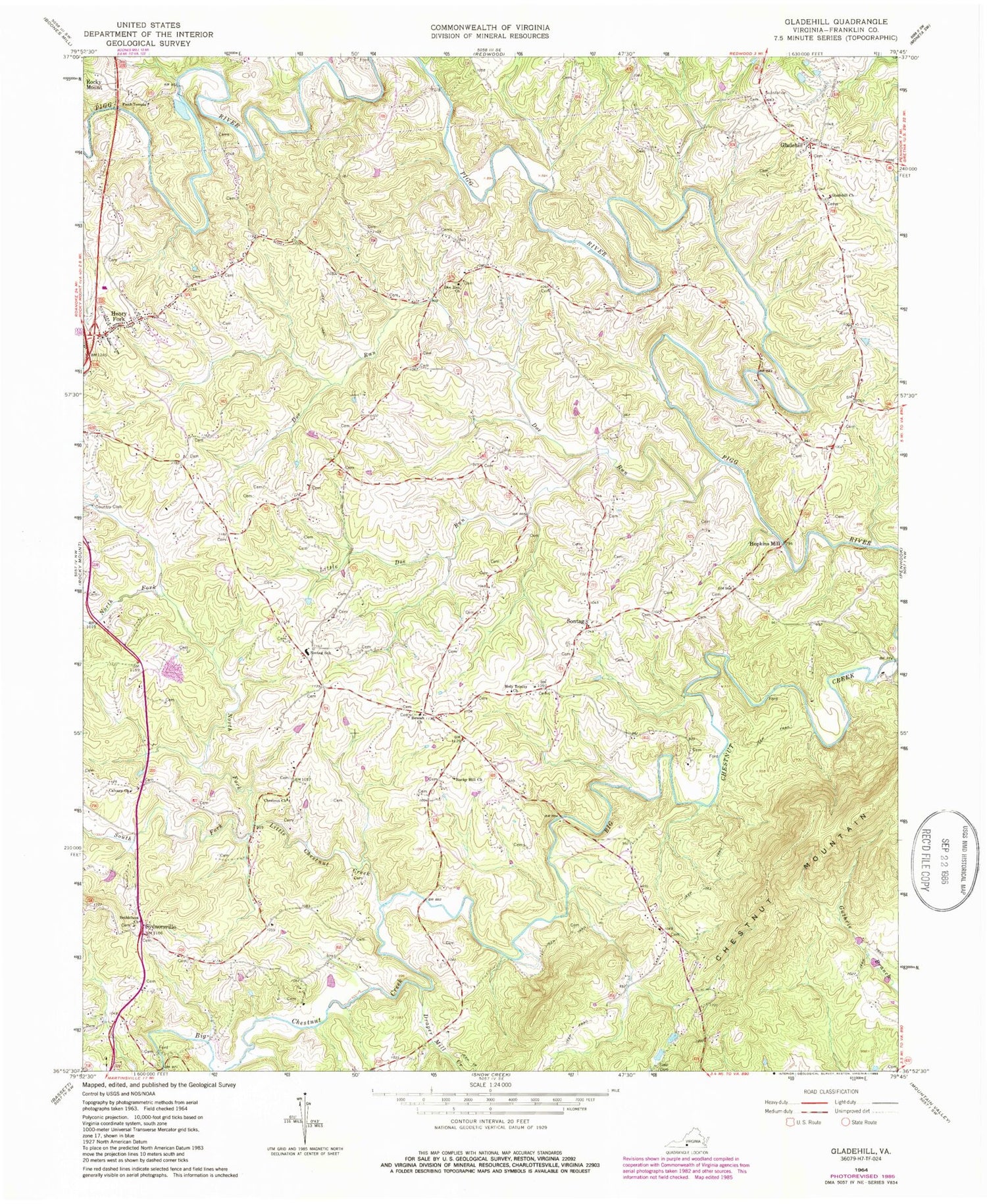
Classic USGS Gladehill Virginia 7.5'x7.5' Topo Map
Couldn't load pickup availability
Historical USGS topographic quad map of Gladehill in the state of Virginia. Typical map scale is 1:24,000, but may vary for certain years, if available. Print size: 24" x 27"
This quadrangle is in the following counties: Franklin.
The map contains contour lines, roads, rivers, towns, and lakes. Printed on high-quality waterproof paper with UV fade-resistant inks, and shipped rolled.
Contains the following named places: Bethlehem Church, Beulah Church, Calvary Church, Chestnut Church, Dee Run Church, Doe Run, Draper Mill Creek, Faith Temple, Gladehill Church, Holy Trinity Church, Little Chestnut Creek, Little Doe Run, North Fork Little Chestnut Creek, Rocky Hill Church, Sontag, Sontag Elementary School, South Fork Little Chestnut Creek, Sydnorsville, Pigg River Dam, Beulah Cemetery, Doe Run Christian Church, Edgewood School (historical), English School (historical), Gap Branch School (historical), High Point School (historical), Lobelia School (historical), Sydnorsville School (historical), Gladehill, Henry Fork, Hopkins Mill, Chesnut Mountain, Altice Cemetery, Anderson - Hodges Cemetery, Anderson - Turner Cemetery, Beach-Scott Cemetery, Bethlehem Cemetery, Blackwell - Taylor Cemetery, Byrd Cemetery, Cooper-Hutcherson Cemetery, Hodges - Hall Cemetery, Lavinder Cemetery, Lavinder-Garvin-Woods Cemetery, Law-Cooper Cemetery, Anderson Family Cemetery, Mills Cemetery, Anderson Family Cemetery, Parcell Cemetery, Tyree and Pinkard Cemetery, Ramsey Cemetery, Tyree-Houston Cemetery, Tyree - Turner - Ramsey Cemetery, Wade - Hodges Cemetery, Woody Cemetery, Woody Cemetery, Woody Cemetery, Woody Cemetery, Woody Cemetery, Woody Cemetery, Woody - Richards Cemetery, Agnew Cemetery, Anderson - Hodges Cemetery, Amos Cemetery, Arrington - Roberts Cemetery, Bousman - Johnson Cemetery, Brooks - Metts - Smith Cemetery, Brown Cemetery, Brown-Fuller Cemetery, Byrd Cemetery, Byrd Cemetery, Chitwood - Altice Cemetery, Cooper Cemetery, Dudley Cemetery, Hodges Cemetery, Dudley-Tyree Cemetery, Eames Cemetery, English Cemetery, English - Tyree Cemetery, Glade Hill Cemetery, Gregory Cemetery, Gregory Cemetery, Henry Fork Cemetery, Henry Fork Church, Hicks - Wade Cemetery, Hodges - Brooks Cemetery, Hodges Family Cemetery, Hodges Cemetery, Hodges Cemetery, Hodges - English Cemetery, Hodges - Lynch - Hall Cemetery, Holland Cemetery, Holland Cemetery, Holland - Tyree Cemetery, Hunt Cemetery, Poise Hunt Cemetery, Jones Cemetery, Law Cemetery, Law Cemetery, Law Cemetery, Lovell - Tyree Cemetery, Mitchell Cemetery, Parcell Cemetery, Parcell Cemetery, Patterson Cemetery, Hunt - Brown Cemetery, Robertson - Bowles Cemetery, Rice Cemetery, Robertson - Hoel Cemetery, Smith Cemetery, Hodges Family Cemetery, Smith-Thomas Cemetery, Stone Cemetery, Stone Cemetery, Taylor Cemetery, Turner - Scott - Sawyers - Cemetery, Tyree Cemetery, Tyree-Gray-Hickman-Washington Cemetery, Wade Cemetery, Wilson - Woods - Stone Cemetery, Wimmer-Hall Cemetery, Young Cemetery, Snow Creek District, Glade Hill Volunteer Fire Department Company 4, Henry Fork Census Designated Place, Abbott Airport, Woody Field, Glade Hill Post Office


