MyTopo
Classic USGS Glastonbury Connecticut 7.5'x7.5' Topo Map
Couldn't load pickup availability
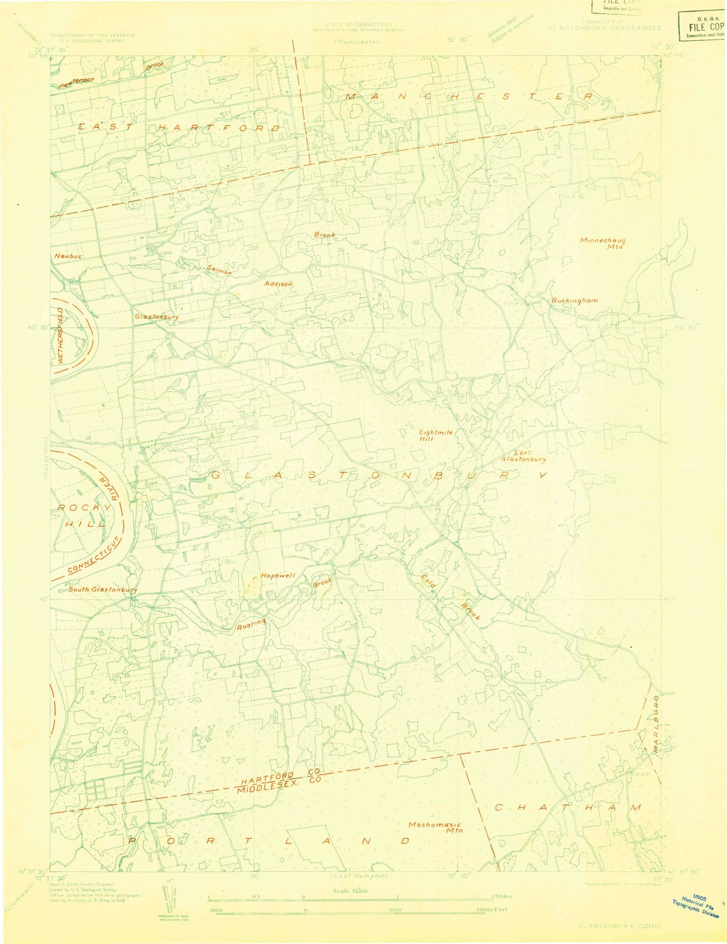
Historical USGS topographic quad map of Glastonbury in the state of Connecticut. Typical map scale is 1:24,000, but may vary for certain years, if available. Print size: 24" x 27"
This quadrangle is in the following counties: Hartford, Middlesex.
The map contains contour lines, roads, rivers, towns, and lakes. Printed on high-quality waterproof paper with UV fade-resistant inks, and shipped rolled.
Contains the following named places: Academy School, Addison, Addison Pond, Angus Park Pond, Barnes School, Belltown Hill, Brainard Pond, Buckingham, Buckland Pond, Bush Hill, Buttonball Lane Elementary School, Caiglo Pond, Camp Bennett, Clark Hill, Cold Brook, Cold Brook Reservoir, Crow Point, Dark Hollow Brook, East Glastonbury, East Hartford Gardens, Eastbury Elementary School, Forbes Village, Forest Village, Glastonbury, Glastonbury Green Cemetery, Glastonbury Meadows, Great Pond, Grindle Brook, Hebron Avenue Elementary School, Hills Pond, Hodges Pond, Holland Brook, Hopewell, Hopewell Elementary School, Hubbard Brook, Kongscut Mountain, Meshomasic Mountain, Meshomasic State Forest, Miller Pond, Minnechaug Mountain, Mott Hill Brook, Naubuc School, Nipsic Bog, Nipsic Cemetery, Doctor Thomas S O'Connell School, Old Church Cemetery, Old Eastbury Cemetery, Our Saviour Cemetery, Pilgrim Church, Potter Pond, Rams Pond, Roaring Brook, Rosers Pond, Round Hill, Saint Augustine Cemetery, Saint Christophers School, Saint James Cemetery, Saint Johns Cemetery, Salmon Brook, Shoddy Mill Pond, Slab Gut Brook, Smith Brook, South Glastonbury, Still Hill Cemetery, Town Woods Hill, Treat Pond, Wassuc Cemetery, Welles Village, Wildcat Brook, Williams Pond, Williams Pond, Stanley T Williams School, Wintergreen Brook, Glastonbury Meadows State Wildlife Area, Reeves Lookout State Wildlife Area, Corporate Center Heliport, Red Gates Pond, Town of Glastonbury, Addison Pond Dam, Williams Pond Dam, Angus Park Pond Dam, Cold Brook Reservoir Dam, Glastonbury Center, Wangunk State Wildlife Area, Buckingham Congregational Church, Bucks Corners, Bucks Corner Village Shopping Center, Congregation Kol Havarim, Cotton Hollow, Cotton Hollow Nature Preserve, Doctor Richard E Gorman Park, East Glastonbury Post Office, East Glastonbury Public Library, Glastonbury Volunteer Fire Department Company 1, Glastonbury Volunteer Fire Department Company 2, Glastonbury Volunteer Fire Department Company 3, Glastonbury Volunteer Fire Department Company 4, Fox Run Mall Shopping Center, Gateway Corporate Park, Gideon Welles School, Glastonbury Community Church, Glastonbury Country Club, Glastonbury High School, Glastonbury Historic District, Glastonbury Meadows, Glastonbury Post Office, Glastonbury Town Hall, Glen Lochen Mall Shopping Center, Glen Lochen Marketplace Shopping Center, Goodwin Playground, Governor William Pitkin School, Griswold Mall Shopping Center, Hale Music Shell, Hassunadchuauck (historical), Herbert T Clark Memorial Park, High Street School, Historical Society Building of Glastonbury, J B Williams Memorial Park, Lutheran Church of Saint Mark, Main Street Plaza Shopping Center, Manchester Country Club, Manchester Recreation Center, Minnechaug Golf Course, Museum on the Green, Nay Aug Shopping Center, Neipsic Golf Course (historical), Nipsic Pond, Old Buckingham Cemetery, One Stop Shopping Center, Our Lady of Peace Church, Pratt Ferry (historical), Putnam Bridge Plaza Shopping Center, Red Hill, Red Spring, Rotary Field, Saint Augustines Church, Saint Christophers Church, Saint Dunstan Church, Saint Lukes Episcopal Church, Salmon Brook Corporate Park, Somerset Square Shopping Center, South End Senior Citizens Center, South Glastonbury Historic District, South Glastonbury Library, South Glastonbury Post Office, Taylor Town, Welles Field, Welles-Turner Memorial Library, Naubuc (historical), Glastonbury Center Census Designated Place, Glastonbury Fire Marshal's Office, East Hartford Fire Department Station 6, Glastonbury Volunteer Fire Department Thomas G Manager Senior Fire Training Facility, Glastonbury Volunteer Ambulance Association, Glastonbury Police Department, Academy School, Addison, Addison Pond, Angus Park Pond, Barnes School, Belltown Hill, Brainard Pond, Buckingham, Buckland Pond, Bush Hill, Buttonball Lane Elementary School, Caiglo Pond, Camp Bennett, Clark Hill, Cold Brook, Cold Brook Reservoir, Crow Point, Dark Hollow Brook, East Glastonbury, East Hartford Gardens, Eastbury Elementary School, Forbes Village, Forest Village, Glastonbury, Glastonbury Green Cemetery, Glastonbury Meadows, Great Pond, Grindle Brook, Hebron Avenue Elementary School, Hills Pond, Hodges Pond, Holland Brook, Hopewell, Hopewell Elementary School, Hubbard Brook, Kongscut Mountain, Meshomasic Mountain, Meshomasic State Forest, Miller Pond, Minnechaug Mountain, Mott Hill Brook, Naubuc School, Nipsic Bog, Nipsic Cemetery, Doctor Thomas S O'Connell School, Old Church Cemetery, Old Eastbury Cemetery, Our Saviour Cemetery, Pilgrim Church, Potter Pond, Rams Pond, Roaring Brook, Rosers Pond, Round Hill, Saint Augustine Cemetery, Saint Christophers School, Saint James Cemetery, Saint Johns Cemetery, Salmon Brook, Shoddy Mill Pond, Slab Gut Brook, Smith Brook, South Glastonbury, Still Hill Cemetery, Town Woods Hill, Treat Pond, Wassuc Cemetery, Welles Village, Wildcat Brook, Williams Pond, Williams Pond, Stanley T Williams School, Wintergreen Brook, Glastonbury Meadows State Wildlife Area, Reeves Lookout State Wildlife Area, Corporate Center Heliport, Red Gates Pond, Town of Glastonbury, Addison Pond Dam, Williams Pond Dam, Angus Park Pond Dam