MyTopo
Classic USGS Glenville Connecticut 7.5'x7.5' Topo Map
Couldn't load pickup availability
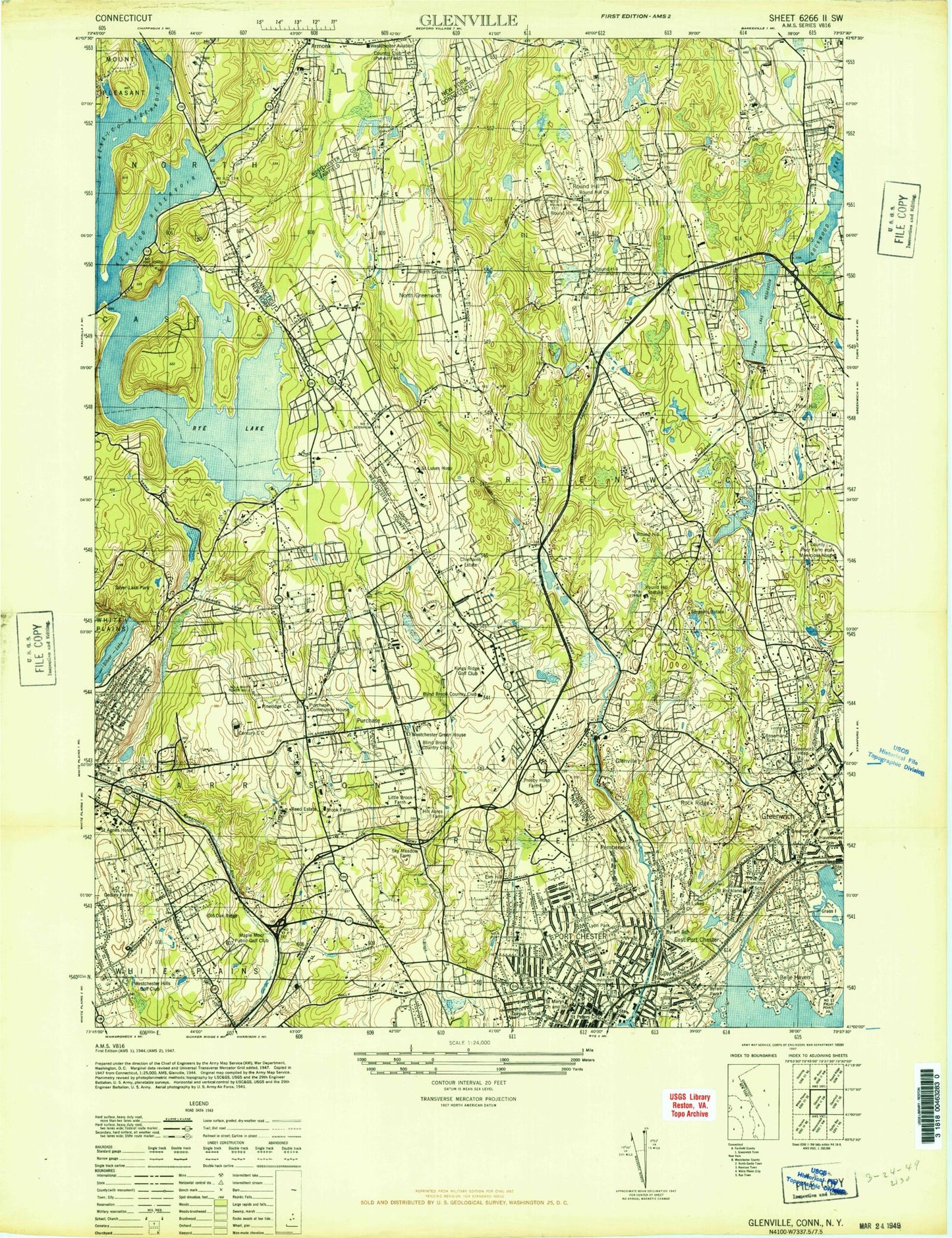
Historical USGS topographic quad map of Glenville in the states of Connecticut, New York. Typical map scale is 1:24,000, but may vary for certain years, if available. Print size: 24" x 27"
This quadrangle is in the following counties: Fairfield, Westchester.
The map contains contour lines, roads, rivers, towns, and lakes. Printed on high-quality waterproof paper with UV fade-resistant inks, and shipped rolled.
Contains the following named places: Belle Haven, Brown Cemetery, Brunswick School, Byram, Byram Harbor, Byram Park, Western Middle School, Carringtons Pond, Close Cemetery, Closes Pond, Convent of the Sacred Heart, Converse Pond Brook, East Branch Converse Pond Brook, Farwells Island, Field Point, Game Cock Island, Glenville, Grass, Green Cemetery, Greenwich, Haithcock School, Hamilton Avenue School, Horseneck Brook, Howe Cemetery, Knapp Cemetery, Lake Mead, Merritt Cemetery, New Lebanon School, North Greenwich, Otter Rocks, Parkway School, Pecks Cemetery, Pemberwick, Putnam Lake, Quaker Ridge, Quaker Ridge Cemetery, Rich Island, Riversville, Rock Ridge, Rockwood Lake, Rosemary Hall, Round Hill, Round Hill, Sacred Heart School, Saint Barnabas Church, Saint Lukes Hospital, Shore Island, Toll Gate Pond, Topping Pond, King Street Baptist Cemetery, Wilcox Pond, Wilshire Pond, Wilson Head, Witherell Hospital, Wolf Swamp, Wooley Pond, Captain Harbor, Round Hill Country Club, Tamarack Country Club, Town of Greenwich, Putnam Reservoir Dam, Pemberwick Dam, Byram River Reservoir, American Felt Dam, Mill Pond, Rockwood Lake Dam, American Can Company Dam, North Lake, Wooley Pond Dam, Indian Spring Pond Dam, Indian Spring Pond, F W Perry Pond Dam, F W Perry Pond, Wilshire Pond Dam, Topping Pond Dam, Spahn Pond Dam, Spahn Pond, West Fork Pond Dam, West Fork Pond, Audubon Center of Greenwich, Belle Haven Club, Bruce Memorial Golf Club, Cheiftan Estate (historical), East Port Chester (historical), Fairview Country Club, Field Club of Greenwich, Glenville School, Greenwich Arts Council, Greenwich Avenue Center Shopping Center, Greenwich Avenue Historic District, Greenwich Common, Greenwich High School, Greenwich Hospital, Greenwich Hospital Library, Greenwich Municipal Center Historic District, Greenwich Post Office, Greenwich Town Hall, Havemeyer Fields, Havenmeyer School (historical), Hebrew Cemetery, North Greenwich Congregational Church, Number 9 Stable (historical), Pine Hill, Roger Sherman Baldwin Park, Round Hill Community Church, Round Hill Community House (historical), Round Hill Stables (historical), Sacred Heart Church, Saint Mary Parish Church, Saint Rochs Church, Sargents Estate (historical), Stanwich Club, Stop and Shop Shopping Center, Thru-Way Shopping Center, Western Greenwich Civic Center Park, Whitby School, Wild Flower Sanctuary, Pemberwick Park, Greenwich Fire Chief's Office, Greenwich Fire Department Station 4 Glenville, Greenwich Fire Department Station 6 Round Hill, Greenwich Fire Department Station 8 Back Country, Greenwich Fire Department Station 3 Byram, Byram Census Designated Place, Glenville Census Designated Place, Greenwich Census Designated Place, Pemberwick Census Designated Place, Glenville Post Office, Downtown Greenwich Post Office, Rock Ridge Census Designated Place, Bear Gutter Creek, Big Peninsula, Cooney Hill, Dark Hollow, East Branch Byram River, East White Plains, Edison School, Forest Lake, Great Island, Bear Gutter Inlet, Harkness Home, High Point Hospital, Kensico Lake, King Street School, Lake Street School, Louden Cove, John Lyon Park, Manhattanville College, Memorial United Methodist Church, Memorial Park, North Street School, Park Avenue School, Parks Cove, Pforzheimer Memorial Bridge, Pleasantville Cove, Resurrection Convent, Ridge Street Country School, Rye Bridge, Rye Lake, Saint Agnes Hospital (historical), Saint Johns Novitiate, Spring Lake, Temple Kneses Tifereth Israel, Underhill Avenue School, Upper Ridge Road School, Wampus River, Webers Cove, Silver Lake, Silver Lake Park, Wetzler Cove, Wilshire Pond Brook, Woodmans Cove, Purchase, Doral Golf Club, Century Country Club, Green Valley Country Club, Maplemoor Golf Club, Old Oaks Country Club, Ridgeway Country Club, Westchester Hills Golf Club, Port Chester, Old Orchard Road Heliport, Westchester County Airport, Safe Flight Instrument Corporation Heliport, Town of Harrison, Town of Rye, Rye Brook, Gedley Farms (historical), Purchase Community House, Number 10 Fire Tower (historical), Westchester Aviation Country Club (historical), Westchester Green House (historical), Presbyterian Hospital Farm (historical), Hill Acres Farm (historical), Little Brook Farm (historical), Brook Farm (historical), Reed Estate, Sky Meadow Farm (historical), Elm Hill Farm (historical), Irvington School (historical), Saint Peter's Episcopal Church, Our Lady of Mercy Roman Catholic Church, Saint Marys School, Corpus Christi Church, Port Chester High School, Saint Paul's Lutheran Church, Parkside Assembly of God, Chinese Alliance Church, Sacred Heart of Jesus Church, Congregation Emanu-El, Ridgeway Alliance Church, White Plains Senior High School, Keio Academy, Purchase Elementary School, Saint Anthony's School, Samuel T Preston School, Lake Street Full Gospel Church, Village of Harrison, Village of Port Chester, Village of Rye Brook, The Flat, Purchase College State University of New York, Crawford Park, Davenport Park, Ophir Farm (historical), Cannon Park, Bates Point, Causeway Island, Glen And Haseco Park, Goose Island, High Point, Liberty Square, Merritts Corner (historical), Summerfield Park, King Street Home, Byram River Bridge