MyTopo
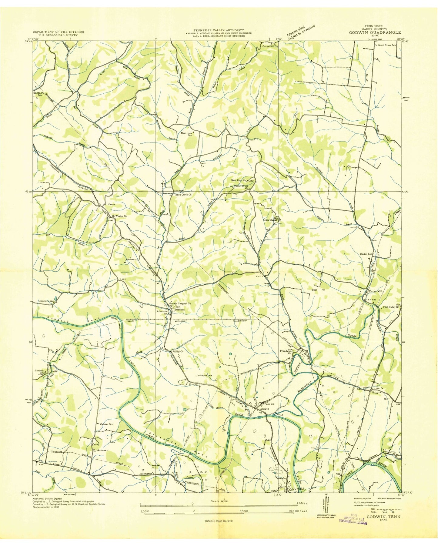
Classic USGS Godwin Tennessee 7.5'x7.5' Topo Map
Couldn't load pickup availability
Historical USGS topographic quad map of Godwin in the state of Tennessee. Map scale may vary for some years, but is generally around 1:24,000. Print size is approximately 24" x 27"
This quadrangle is in the following counties: Maury.
The map contains contour lines, roads, rivers, towns, and lakes. Printed on high-quality waterproof paper with UV fade-resistant inks, and shipped rolled.
Contains the following named places: Alexander Bend, Allen Branch, Athendale, Athendale School, Bassham Branch, Bear Creek, Beech Grove Church, Beech Grove School, Bel Air, Ben, Bethany Church, Betty Lee Park, Bookers Ferry, Brooks Cemetery, Brown Cemetery, Camp Scout Haven, Carters Creek, Cavespring Branch, Chantay Acres, Columbia Fire Department Station 3, Commissioner District 1, Commodore D Loveless Bridge, Concord, Concord Cumberland Presbyterian Church, Concord School, Dark Hollow, Darks Mill, District 18, District 20, Dodson Cemetery, Dowell Branch, Dowell Cemetery, Elmwood Academy, First Cumberland Church, Fitzgerald Cemetery, Flint Valley, Flint Valley Church, Flint Valley School, Foster Cemetery, Foxall Hill, Friendship Church, Gaskill Branch, Gin Branch, Godwin, Godwin Chapel Church, Godwin School, Grassy Branch, Gravel Hill Church, Green Hill, Greenlick Creek, Haley Branch, Hardy Acres, Harlem Cemetery, Harlen School, Harris Cemetery, Haywood Cemetery, Haywood Hollow, Henderson Chapel, Hight Cemetery, Hooker Number Six Dam, Hooker Number Six Tailings Pond, Hooker Tailings Pond Number Ten Dam, Howells Lake, Hughes Cemetery, Ingram Lake, Jackson Heights, Jocobs Cemetery, Knob Creek, Knob Creek Cemetery, Knob Creek Church, Kraus, Lasting Hope Cemetery, Lasting Hope Cumberland Presbyterian Church, Latta, Little Bigby Creek, Lockridge Camp Ground, Lot Chapel, Maguire Cemetery, Mahon Branch, Maury County Sheriff's Department, Miller Cemetery, Monsanto, Monsanto Number Fifteen Dam, Monsanto Number Fifteen Lake, Monsanto Tailings Pond Number Five Dam, Monsanto Tailings Pond Number Four Dam, Monsanto Tailings Pond Number Three Dam, Mount Wesley Cemetery, Mount Wesley Church, Mowd, Murphy and Rone Mine, Natco, New Hope, New Hope Church, New Hope Community Center, New Hope School, Northway Shopping Center, Old Knob Creek Cemetery, Parks Mine, Partons Mill, Phillippi Church, Polk Cemetery, Porter Cemetery, Presnell Tailings Pond, Presnell Tailings Pond Dam, Ragsdale Hollow, Ranel Branch, River Heights, Riverview Church, Roberts Cemetery, Roberts Chapel, Romantown Branch, Royal Oaks, Rutherford Bridge, Rutherford Creek, Saint Lukes Church, Santa Fe School, Sellers Bluff, Sellers Mine, Sowell Branch, Sparkman Lake, Sutherland Hollow, Tailings Pond Number Five, Tailings Pond Number Four, Tailings Pond Number Seven, Tailings Pond Number Seven Dam, Tailings Pond Number Ten, Tailings Pond Number Three, Taylor Cemetery, Taylor Hollow, Taylor Mine, Tea Hill, Timmons Cemetery, Vestal Cemetery, Voorhies Cemetery, Watson Cemetery, Watson Hollow, Webster School, West Cemetery, West Mine, West Point Cemetery, West Point Church, White Bend, Williams Cemetery, Wisener Cemetery, Wisner Cemetery, Wisner Hill, Witherspoon Cemetery, ZIP Code: 38401