MyTopo
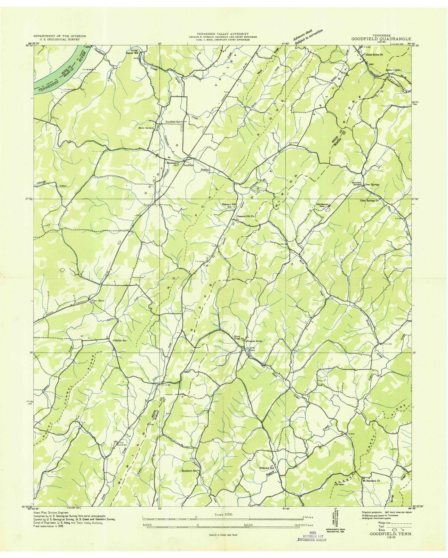
Classic USGS Goodfield Tennessee 7.5'x7.5' Topo Map
Couldn't load pickup availability
Historical USGS topographic quad map of Goodfield in the state of Tennessee. Typical map scale is 1:24,000, but may vary for certain years, if available. Print size: 24" x 27"
This quadrangle is in the following counties: McMinn, Meigs, Rhea.
The map contains contour lines, roads, rivers, towns, and lakes. Printed on high-quality waterproof paper with UV fade-resistant inks, and shipped rolled.
Contains the following named places: Goodfield Valley, McMinn Ridge, Shiloh Cemetery, Shiloh Ridge, Short Creek, Ward Cemetery, Able Ridge, Allen Branch, Breeden Pond, Brush Creek, Coffman Cemetery, Coldwater Branch, Cotton Port Ridge, Cox Cemetery, Elder Hollow, Goforth Spring, Goodfield Church, Goodfield Creek, Hale Hollow Creek, Hardin Creek, Hawk Spring, Hill Cemetery, Hill Spring, Howser Cemetery, Hyde Cemetery, Marler Spring, Mayberry Branch, McCorkle Spring, McKenzie Cemetery, Melton Cemetery, Middle Ridge, Minnett Cemetery, Mount Harmony Church, Perkinson Spring, Perry Cemetery, Pierce Pond, Plank Cemetery, Plank Spring, Pleasant Hill Branch, Pleasant Hill Church, Rockholt Spring, Sewell Cemetery, Shiloh Church, Short Creek Church, Short Creek Spring, Union Grove Church, Bethsadia Church, Clear Springs Church, Decatur Creek, Folger (historical), Blevin Mill (historical), Goodfield Cemetery, Goodfield Shoals, Pleasant Hill School (historical), Shiloh School (historical), Clear Springs, Goodfield, Hillsview, Buckhorn School (historical), Coffmans Store (historical), Malones Store (historical), Bethsadia Cemetery, Pleasant Hill Cemetery, Hillsview School (historical), Goodfield School (historical), Union Grove School (historical), Allen, Beta, Hale Hollow, Harmon Hollow, Union Grove, Brush Creek School (historical), Cedar Valley Elementary School, Big Spring Post Office, Clear Springs Baptist Church Cemetery, Short Creek Cemetery, Meigs County Emergency Services Fire Rescue Station 3, Hillsview Volunteer Fire Department District 8, Meigs County Emergency Services Fire Rescue Station 2, Goodfield Valley, McMinn Ridge, Shiloh Cemetery, Shiloh Ridge, Short Creek, Ward Cemetery, Able Ridge, Allen Branch, Breeden Pond, Brush Creek, Coffman Cemetery, Coldwater Branch, Cotton Port Ridge, Cox Cemetery, Elder Hollow, Goforth Spring, Goodfield Church, Goodfield Creek, Hale Hollow Creek, Hardin Creek, Hawk Spring, Hill Cemetery, Hill Spring, Howser Cemetery, Hyde Cemetery, Marler Spring, Mayberry Branch, McCorkle Spring, McKenzie Cemetery, Melton Cemetery, Middle Ridge, Minnett Cemetery, Mount Harmony Church, Perkinson Spring, Perry Cemetery, Pierce Pond, Plank Cemetery, Plank Spring, Pleasant Hill Branch, Pleasant Hill Church, Rockholt Spring, Sewell Cemetery, Shiloh Church, Short Creek Church, Short Creek Spring, Union Grove Church, Bethsadia Church, Clear Springs Church, Decatur Creek, Folger (historical), Blevin Mill (historical), Goodfield Cemetery, Goodfield Shoals, Pleasant Hill School (historical), Shiloh School (historical), Clear Springs, Goodfield, Hillsview, Buckhorn School (historical), Coffmans Store (historical), Malones Store (historical), Bethsadia Cemetery, Pleasant Hill Cemetery, Hillsview School (historical), Goodfield School (historical), Union Grove School (historical), Allen, Beta, Hale Hollow, Harmon Hollow, Union Grove, Brush Creek School (historical), Cedar Valley Elementary School, Big Spring Post Office, Clear Springs Baptist Church Cemetery, Short Creek Cemetery, Meigs County Emergency Services Fire Rescue Station 3, Hillsview Volunteer Fire Department District 8, Meigs County Emergency Services Fire Rescue Station 2, Goodfield Valley, McMinn Ridge, Shiloh Cemetery, Shiloh Ridge, Short Creek, Ward Cemetery, Able Ridge, Allen Branch, Breeden Pond, Brush Creek, Coffman Cemetery, Coldwater Branch, Cotton Port Ridge, Cox Cemetery, Elder Hollow, Goforth Spring, Goodfield Church, Goodfield Creek, Hale Hollow Creek, Hardin Creek, Hawk Spring, Hill Cemetery, Hill Spring, Howser Cemetery, Hyde Cemetery, Marler Spring, Mayberry Branch, McCorkle Spring, McKenzie Cemetery, Melton Cemetery, Middle Ridge, Minnett Cemetery, Mount Harmony Church, Perkinson Spring, Perry Cemetery, Pierce Pond, Plank Cemetery, Plank Spring, Pleasant Hill Branch, Pleasant Hill Church, Rockholt Spring, Sewell Cemetery, Shiloh Church, Short Creek Church, Short Creek Spring, Union Grove Church, Bethsadia Church, Clear Springs Church, Decatur Creek, Folger (historical), Blevin Mill (historical), Goodfield Cemetery, Goodfield Shoals, Pleasant Hill School (historical), Shiloh School (historical), Clear Springs, Goodfield, Hillsview, Buckhorn School (historical), Coffmans Store (historical), Malones Store (historical), Bethsadia Cemetery, Pleasant Hill Cemetery, Hillsview School (historical), Goodfield School (historical), Union Grove School (historical), Allen, Beta, Hale Hollow, Harmon Hollow, Union Grove, Brush Creek School (historical), Cedar Valley Elementary School, Big Spring Post Office, Clear Springs Baptist Church Cemetery, Short Creek Cemetery, Meigs County Emergency Services Fire Rescue Station 3, Hillsview Volunteer Fire Department District 8