MyTopo
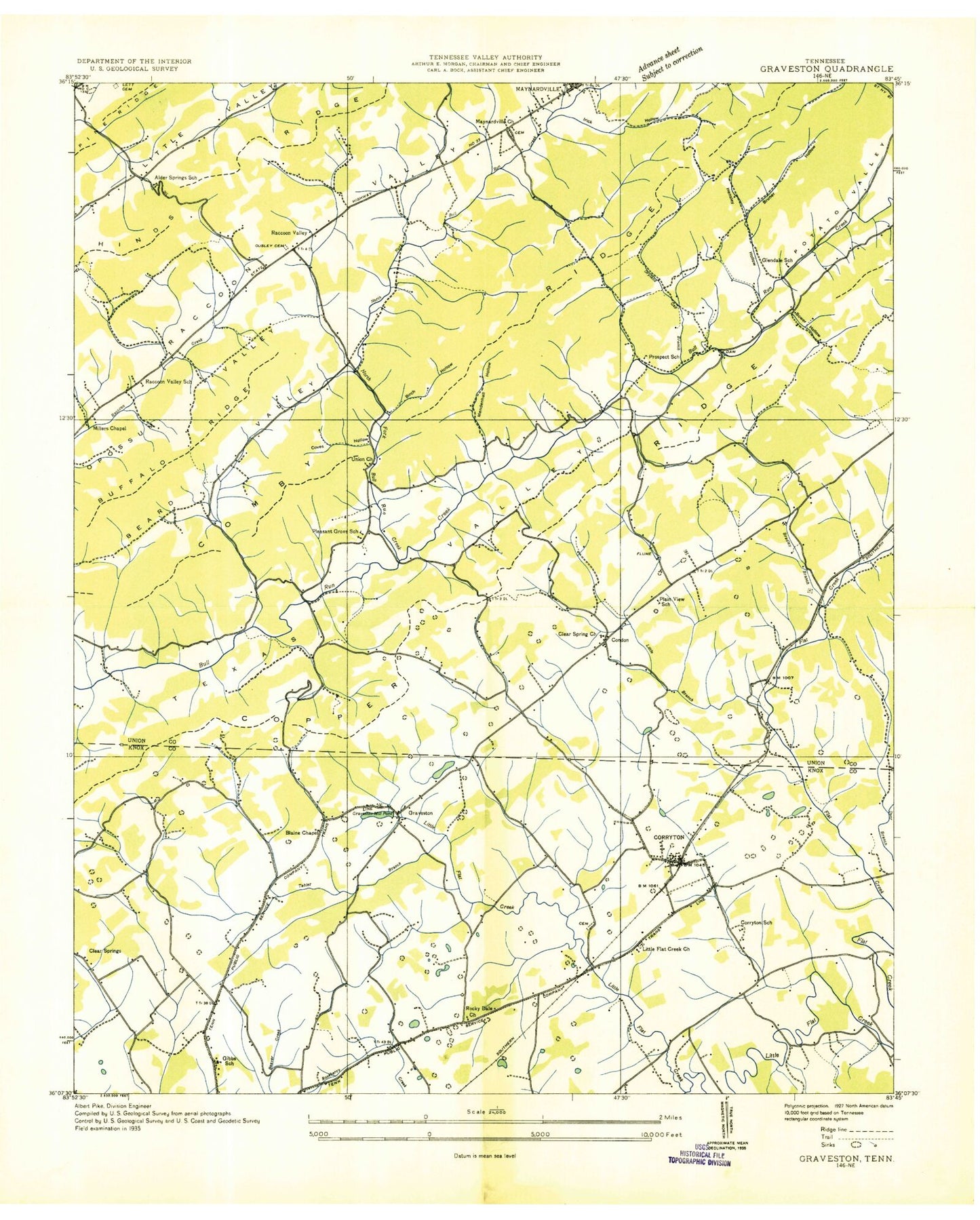
Classic USGS Graveston Tennessee 7.5'x7.5' Topo Map
Couldn't load pickup availability
Historical USGS topographic quad map of Graveston in the state of Tennessee. Typical map scale is 1:24,000, but may vary for certain years, if available. Print size: 24" x 27"
This quadrangle is in the following counties: Knox, Union.
The map contains contour lines, roads, rivers, towns, and lakes. Printed on high-quality waterproof paper with UV fade-resistant inks, and shipped rolled.
Contains the following named places: Buffalo Ridge, Comb Ridge, Lett Cemetery, Stover Gap, Tabler Branch, Union Church, Wood Hollow, Wyrick Cemetery, Ailor Cemetery, Ailor Gap, Archer Cemetery, Baker Cemetery, Beeler Hollow, Big Spring, Birch Hollow, Black Hollow, Blaine Chapel, Bower Hollow, Bradley Branch, Bruner Hollow, Chesney Cemetery, Chesney Cemetery, Clapp Hollow, Corryton, Corum Cemetery, Cox Cemetery, Dale Chapel, Dryland Branch, Gibbs School, Graveston, Graveston Mill Pond, Hamilton Gap, Hensley Hollow, Hubbs Cemetery, Johnson Cemetery, Kitts Cemetery, Kitts Hollow, Little Branch, Little Flat Creek Church, McBee Cemetery, Mendenhall Hollow, Miller Chapel, Miller Knobs, New Friendship Church, North Fork Bullrun Creek, Old Flat Creek Cemetery, Ousley Cemetery, Plain View School, Pleasant Grove School, Raccoon Valley, Rockydale Cemetery, Rockydale Church, Sharp Cemetery, Sharp Cemetery, Thunder Hollow Dam, Thunder Hollow Lake, Potato Valley, Turner Cemetery, Arick Hollow, Bullrun School, Clear Branch Church, Cove Hollow, Damewood Hollow, Woodburn (historical), House Mountain (historical), Alder Springs, Alder Springs Baptist Church, Alder Springs School (historical), Glendale School (historical), Horace Maynard High School, Luttrell Elementary School, Maynardville Baptist Church, Maynardville Church (historical), Maynardville Elementary School, Plain View School (historical), Prospect School (historical), Raccoon Valley School (historical), Corryton Baptist Church, Gibbs Elementary School, Gibbs High School, Gibbs Middle School, Clear Branch Cemetery, Pleasant Grove Cemetery, Pleasant Valley, Corryton Elementary School, Corryton Division (historical), Maynardville Division (historical), Corryton Post Office, Condon, City of Plainview, City of Maynardville, Commissioner District 1, Union County Rescue Squad, Maynardville Fire Department, Rural / Metro Fire Department Knox County Station 33, Kimberden Farms, Maynardville Police Department, Union County Sherriff's Department, Maynardville Post Office, Commissioner District 7, Buffalo Ridge, Comb Ridge, Lett Cemetery, Stover Gap, Tabler Branch, Union Church, Wood Hollow, Wyrick Cemetery, Ailor Cemetery, Ailor Gap, Archer Cemetery, Baker Cemetery, Beeler Hollow, Big Spring, Birch Hollow, Black Hollow, Blaine Chapel, Bower Hollow, Bradley Branch, Bruner Hollow, Chesney Cemetery, Chesney Cemetery, Clapp Hollow, Corryton, Corum Cemetery, Cox Cemetery, Dale Chapel, Dryland Branch, Gibbs School, Graveston, Graveston Mill Pond, Hamilton Gap, Hensley Hollow, Hubbs Cemetery, Johnson Cemetery, Kitts Cemetery, Kitts Hollow, Little Branch, Little Flat Creek Church, McBee Cemetery, Mendenhall Hollow, Miller Chapel, Miller Knobs, New Friendship Church, North Fork Bullrun Creek, Old Flat Creek Cemetery, Ousley Cemetery, Plain View School, Pleasant Grove School, Raccoon Valley, Rockydale Cemetery, Rockydale Church, Sharp Cemetery, Sharp Cemetery, Thunder Hollow Dam, Thunder Hollow Lake, Potato Valley, Turner Cemetery, Arick Hollow, Bullrun School, Clear Branch Church, Cove Hollow, Damewood Hollow, Woodburn (historical), House Mountain (historical), Alder Springs, Alder Springs Baptist Church, Alder Springs School (historical), Glendale School (historical), Horace Maynard High School, Luttrell Elementary School, Maynardville Baptist Church, Maynardville Church (historical), Maynardville Elementary School, Plain View School (historical), Prospect School (historical), Raccoon Valley School (historical), Corryton Baptist Church, Gibbs Elementary School, Gibbs High School, Gibbs Middle School, Clear Branch Cemetery, Pleasant Grove Cemetery, Pleasant Valley, Corryton Elementary School, Corryton Division (historical), Maynardville Division (historical), Corryton Post Office, Condon, City of Plainview, City of Maynardville, Commissioner District 1, Union County Rescue Squad, Maynardville Fire Department, Rural / Metro Fire Department Knox County Station 33, Kimberden Farms, Maynardville Police Department, Union County Sherriff's Department, Maynardville Post Office, Commissioner District 7