MyTopo
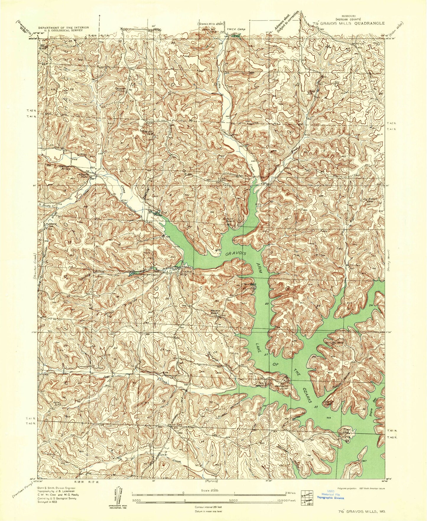
Classic USGS Gravois Mills Missouri 7.5'x7.5' Topo Map
Couldn't load pickup availability
Historical USGS topographic quad map of Gravois Mills in the state of Missouri. Typical map scale is 1:24,000, but may vary for certain years, if available. Print size: 24" x 27"
This quadrangle is in the following counties: Morgan.
The map contains contour lines, roads, rivers, towns, and lakes. Printed on high-quality waterproof paper with UV fade-resistant inks, and shipped rolled.
Contains the following named places: Bogue Bay, Clabber Creek, Coffee Creek, Dry Branch, Factory Hollow, Forcade Hollow, Gibson Point, Gravois Arm, Hibdon Hollow, Gladstone Cove, Lee Hollow, Little Gravois Creek, Market Point, Mitchell Mine, North Brushy Creek, Possum Hollow, Prairie Hollow, Rastorfer Hollow, Spring Branch, Washburn Point, Wilson Hollow, Brushy Creek, Gravois Creek, Soap Creek, Saint Patricks Church, Cedar Point, Gravois Mills Spring, Camp Sharon, Community Chapel, Sidebottom Cemetery, Harbour Airport, Camp Santa Fe, South School, Holst Cemetery, Rastorfer Cemetery, Ivy Cemetery, Hume Cemetery, Fair View School (historical), Hubbard School (historical), Holst School (historical), Coffee School (historical), Gladstone (historical), Sherlock Field, Yarger Lake Dam, Number 841 Reservoir, Lafayette Lake Dam, Gravois Mills, Township of Osage, Town of Gravois Mills, Gravois Fire Protection District Station 1, Gravois Fire Protection District Station 2, Gravois Mills Natural Bridge, Gravois Mills Post Office, Bogue Bay, Clabber Creek, Coffee Creek, Dry Branch, Factory Hollow, Forcade Hollow, Gibson Point, Gravois Arm, Hibdon Hollow, Gladstone Cove, Lee Hollow, Little Gravois Creek, Market Point, Mitchell Mine, North Brushy Creek, Possum Hollow, Prairie Hollow, Rastorfer Hollow, Spring Branch, Washburn Point, Wilson Hollow, Brushy Creek, Gravois Creek, Soap Creek, Saint Patricks Church, Cedar Point, Gravois Mills Spring, Camp Sharon, Community Chapel, Sidebottom Cemetery, Harbour Airport, Camp Santa Fe, South School, Holst Cemetery, Rastorfer Cemetery, Ivy Cemetery, Hume Cemetery, Fair View School (historical), Hubbard School (historical), Holst School (historical), Coffee School (historical), Gladstone (historical), Sherlock Field, Yarger Lake Dam, Number 841 Reservoir, Lafayette Lake Dam, Gravois Mills, Township of Osage, Town of Gravois Mills, Gravois Fire Protection District Station 1, Gravois Fire Protection District Station 2, Gravois Mills Natural Bridge, Gravois Mills Post Office, Bogue Bay, Clabber Creek, Coffee Creek, Dry Branch, Factory Hollow, Forcade Hollow, Gibson Point, Gravois Arm, Hibdon Hollow, Gladstone Cove, Lee Hollow, Little Gravois Creek, Market Point, Mitchell Mine, North Brushy Creek, Possum Hollow, Prairie Hollow, Rastorfer Hollow, Spring Branch, Washburn Point, Wilson Hollow, Brushy Creek, Gravois Creek, Soap Creek, Saint Patricks Church, Cedar Point, Gravois Mills Spring, Camp Sharon, Community Chapel, Sidebottom Cemetery, Harbour Airport, Camp Santa Fe, South School, Holst Cemetery, Rastorfer Cemetery, Ivy Cemetery, Hume Cemetery, Fair View School (historical), Hubbard School (historical), Holst School (historical), Coffee School (historical), Gladstone (historical), Sherlock Field, Yarger Lake Dam, Number 841 Reservoir, Lafayette Lake Dam, Gravois Mills, Township of Osage, Town of Gravois Mills, Gravois Fire Protection District Station 1, Gravois Fire Protection District Station 2, Gravois Mills Natural Bridge, Gravois Mills Post Office