MyTopo
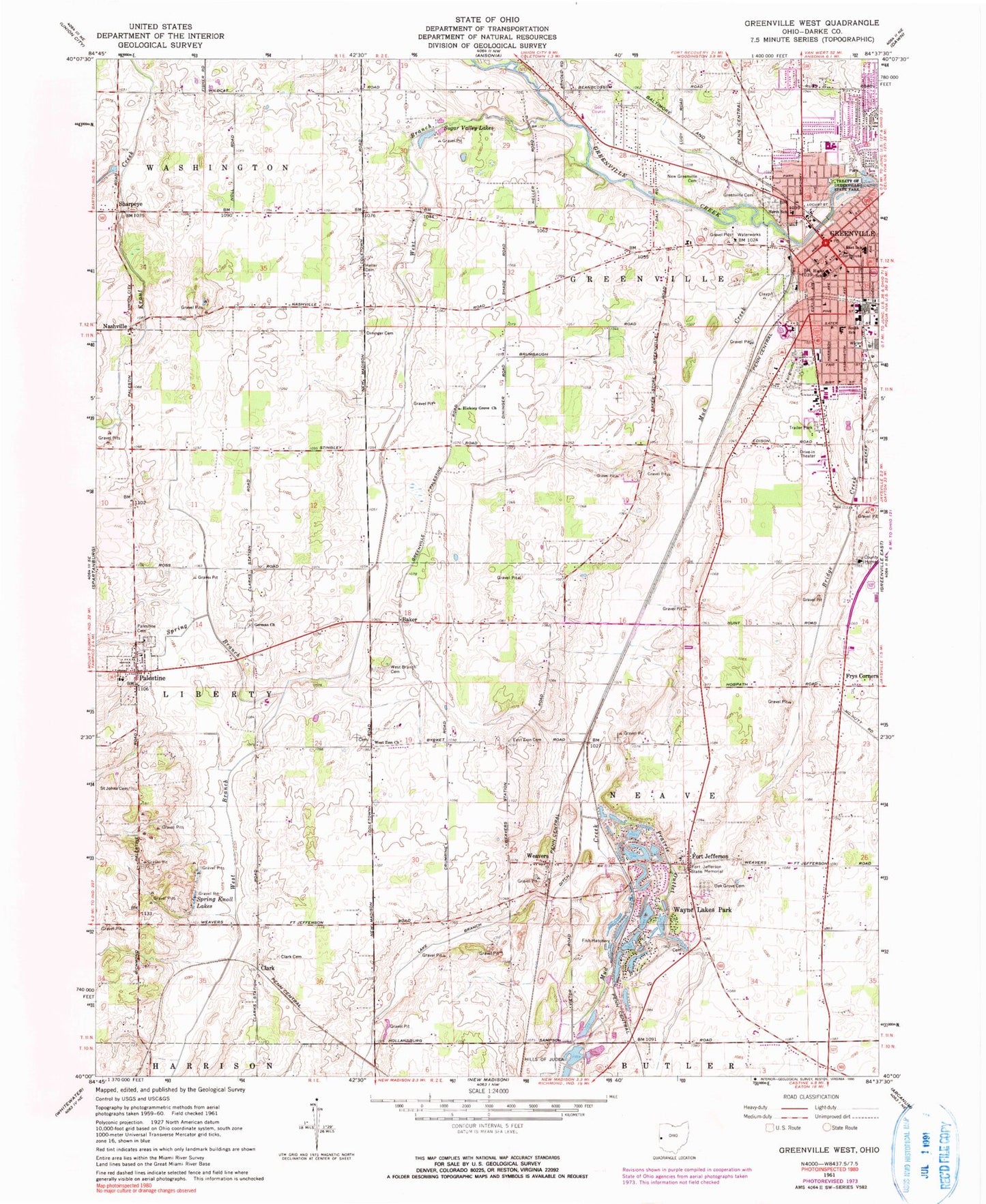
Classic USGS Greenville West Ohio 7.5'x7.5' Topo Map
Couldn't load pickup availability
Historical USGS topographic quad map of Greenville West in the state of Ohio. Map scale may vary for some years, but is generally around 1:24,000. Print size is approximately 24" x 27"
This quadrangle is in the following counties: Darke.
The map contains contour lines, roads, rivers, towns, and lakes. Printed on high-quality waterproof paper with UV fade-resistant inks, and shipped rolled.
Contains the following named places: Annie Oakley Park, Apostolic Church, Baker, Baker Mills Post Office, Burkholder Farm, Christian Missionary Alliance Church, Church of the Nazarene, Clark, Clark Cemetery, Colonial Mobile Home Park, Community Church of Greenville, Darke County Courthouse, Darke County Fairgrounds, Darke County Home, Darke County Jail, Darke County Sheriff's Office, Dininger Cemetery, East Elementary School, East Main Church of Christ, East Zion Cemetery, Euclid Shopping Center, Evangelical United Methodist Church, First Church of Christ Scientist, First Congregational Church, First United Church of Christ, First United Methodist Church, First United Presbyterian Church, Fort Jefferson, Fort Jefferson Post Office, Fort Jefferson State Memorial, Fort Jefferson Station, Fountain of Life Church, Fourth Street Church of God, Frys Corners, Garber Farms, Garst Museum, Grace Lutheran Church, Greenville, Greenville Church of the Brethren, Greenville City Hall, Greenville City Park, Greenville Fire Department, Greenville High School, Greenville Junior High School, Greenville Police Department, Greenville Post Office, Greenville Public Library, Greenville South Broadway Commercial Historic District, Greenville Union Cemetery, Greenville Water Works, Heller Cemetery, Henry Saint Clair Memorial Building, Hickory Grove Church, Hills of Judea, Kingdom Hall of Jehovahs Witnesses, Lake Branch Ditch, Liberty Township Volunteer Fire Department, Maher Farms, Miller Cemetery, Miller Grove German Baptist Church, Mount Pleasant, Mud Creek, Mud Creek Prairie, Nashville, Nashville Cemetery, Nashville United Methodist Church, New Greenville Cemetery, North Elementary School, Palestine, Palestine Cemetery, Palestine Post Office, Pioneer Cemetery, Prairie Outlet, Prairie View Farms, Rank Farm, Rolling Acre Hog Farm, Saint Johns Cemetery, Saint Mary School, Saint Marys Catholic Church, Saint Paul United Church of Christ, Saint Pauls Episcopal Church, Saint Pauls Lutheran Church, Scott Farms, Sharpeye, Sharpeye Cemetery, Sharpeye Post Office, Shawnee Prairie Preserve, Shives Farm, Slagle Sand and Gravel Pit, South Elementary School, Southside Park, Speedway Auto Theatre, Spirit Medical Transport Limited Liability Company, Spring Branch, Spring Knoll Lakes, Sugar Valley Lakes, Tecumseh Boulder Historical Site, Tecumsehs Point, Township of Greenville, Township of Neave, Treaty of Greenville State Park, Tri-Village Primary School, Twin Pine Farms, United Missionary Church, Veitch Farms, Village of Palestine, Village of Wayne Lakes, Wayne HealthCare, Wayne Lakes Cemetery, Wayne Lakes Park, Weavers, Weavers Station Post Office, Weimers Mill, West Branch Cemetery, West Branch Greenville Creek, West Zion Cemetery, West Zion Church, WGVO-FM (Greenville), White Springs Golf Course, Winner Farms, ZIP Codes: 45331, 45352