MyTopo
Classic USGS Gretna Nebraska 7.5'x7.5' Topo Map
Couldn't load pickup availability
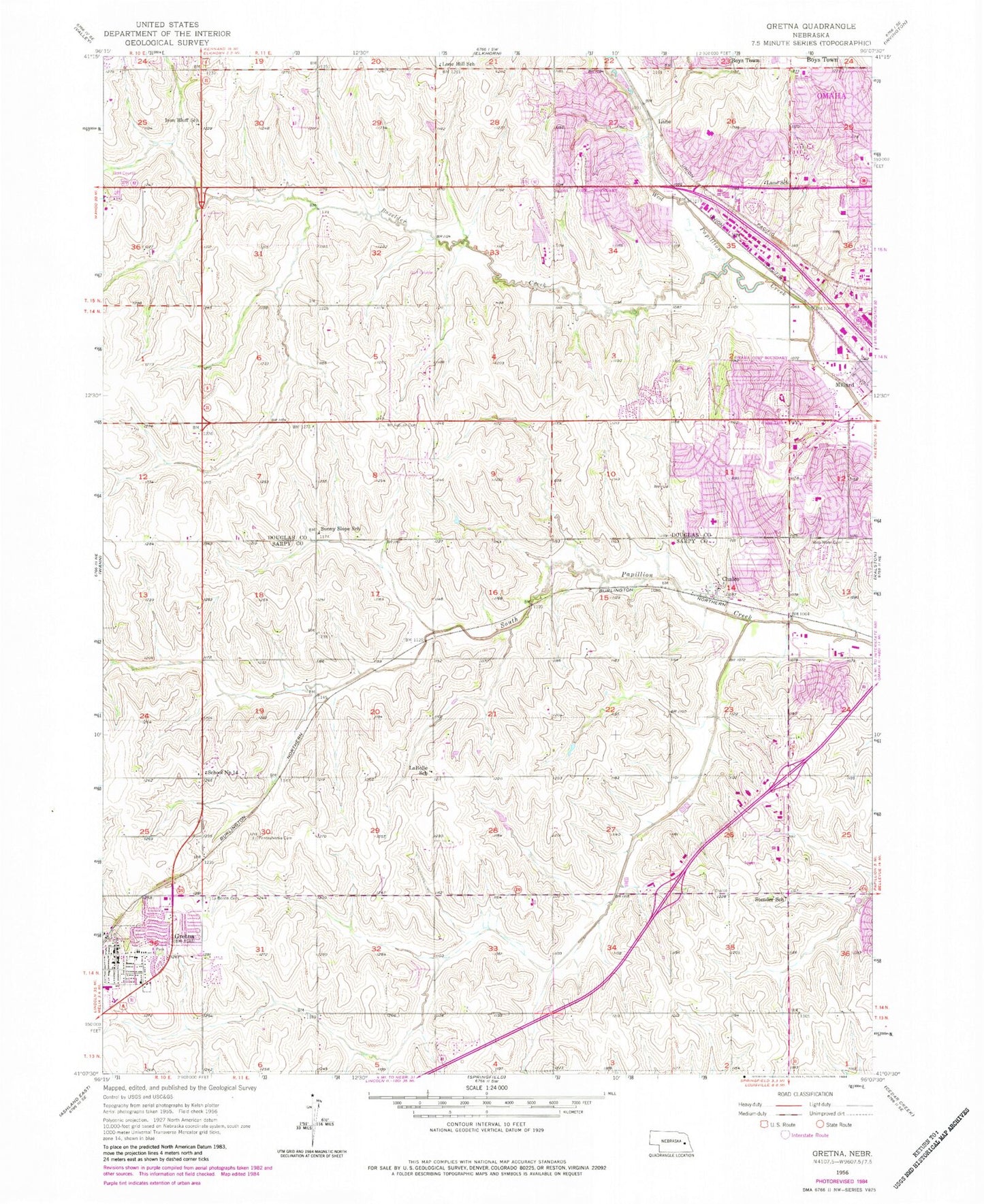
Historical USGS topographic quad map of Gretna in the state of Nebraska. Map scale may vary for some years, but is generally around 1:24,000. Print size is approximately 24" x 27"
This quadrangle is in the following counties: Douglas, Sarpy.
The map contains contour lines, roads, rivers, towns, and lakes. Printed on high-quality waterproof paper with UV fade-resistant inks, and shipped rolled.
Contains the following named places: A Better View, Abiding Savior Lutheran Church, Ackerman Elementary School, Alegent Health Immediate Care Clinic, Anderson Field, Beadle Creek, Black Elk Elementary School, Boxelder Creek, Boys Town Center Pediatric Clinic, Boys Town National Research Hospital - Pacific Street, Bryan Elementary School, Center Park, Chalco, Chalco Census Designated Place, Chalco Hills Recreation Area, Chalco Hills Trails, Chalco Post Office, CHI Health - Lakeside Hospital, Chicago Election Precinct, City of Gretna, Community Care of America Center, Community Covenant Church, Cottonwood Park, Crystal Creek, Discovery Soccer Complex, Divine Shepherd Lutheran Church, Ed Zorinsky Recreation Area, Englewood Park, Faithful Shepherd Presbyterian Church, Family Medicine Associates Center, Farmers Union Co-operative Association Elevator, Forest City Number 1 Election Precinct, Frontier Clinic Incorporated, George Beadle Middle School, Georgetowne Family Dentistry Center, Gold Circle Pediatric Clinic, Good Shepherd Baptist Church, Good Shepherd Lutheran Church, Gretna, Gretna Chiropractic Center, Gretna City Park, Gretna Community Church, Gretna Dental Health Center, Gretna Elementary School, Gretna Foursquare Church, Gretna High School, Gretna Post Office, Gretna Public Library, Gretna Volunteer Fire and Rescue Department District 1, Harry Andersen Middle School, Harvey Oaks Baptist Church, Harvey Oaks Elementary School, Harvey Oaks Park, Holling Heights Elementary School, Hope Presbyterian Church, Iron Bluff School, J Sterling Morton Elementary School, John G Neihardt Elementary School, Kingsway Christian Church, Kingswood Park, LaBelle School, Laborde Cemetery, Lane, Lane School, Leo Royal Memorial Park, Living Hope Evangelical Lutheran Church, Lone Hill School, Love and Grace Family Church, Mackey Elevator Incorporated Elevator, Marshall Drive Baptist Church, Midwest Eye Care PC Building, Midwest Urology Associates PC Building, Midwest Urology Associates PC Center, Millard Alliance Church, Millard Bible Church, Millard Election Precinct, Millard Highlands Park, Millard Highway Fifty Trail, Millard Mobile Home Park, Millard North Middle School, Millard South High School, Millard West High School, Mission Creek, Montclair Elementary School, Morton Creek, Mount Auburn Cemetery, Nebraska Orthopaedic Hospital, Norman Rockwell Elementary School, North Boxelder Creek, North Wehrspann Creek, Oak View Creek, Oak View Mall, Omaha Fire Department - Station 56, Omaha Fire Department - Station 63, Omaha Fire Department - Station 65, Omaha Fire Department - Station 77, Pacific Hollow Creek, Papillion Creek Dam D-38, Papillion Creek Reservoir D-38, Parkside Park, Pennsylvania Cemetery, Peterson Park, Physicians Clinic, Postal Impressions Retail Post Office, Rainbow Dental Center, Rejoice Lutheran Church, Resurrection Lutheran Church, Richland II Election Precinct, Richland IV Election Precinct, Richland V Election Precinct, Richland VI Election Precinct, Richland VII Election Precinct, Richland VIII Election Precinct, Russell Middle School, Saint Patricks Church, Saint Patricks Church of Omaha, Saint Stephen the Martyr School, Saint Thomas Lutheran Church, Saint Wenceslaus Church, Saint Wenceslaus School, School Number 14, Shadow Ridge Country Club, Skutt Catholic High School, Skyline, South Wehrspann Creek, Southwest Church of the Nazarene, Stender School, Stony Brook Dental Center, Sunny Slope School, Tiburon Creek, Tiburon Golf Club, United Methodist Church, University Medical Associates - Mission Village, University Medical Associates Building - Harvey Oaks, University Medical Associates Center - Summit Plaza, Voss Mohr Cemetery, Walnut Grove Park, Wehrspann Creek, Wehrspann Lake, West Papio Trail, Westchester Park, Whitehawk Creek, Wiebe Dam, Wiebe Reservoir, Willa Cather Elementary School, Willowdale Elementary School, Willowood Airport, Zorinsky Lake, Zorinsky Park Trail, ZIP Codes: 68130, 68135, 68136, 68138