MyTopo
Classic USGS Guntersville Dam Alabama 7.5'x7.5' Topo Map
Couldn't load pickup availability
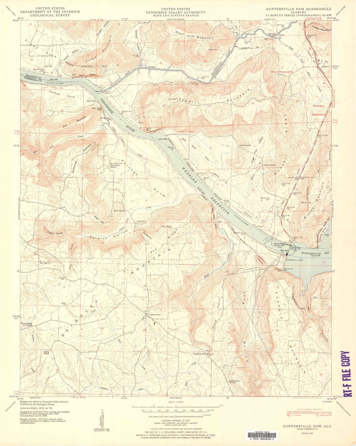
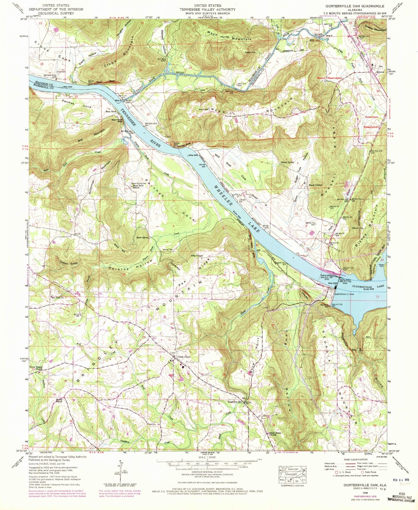
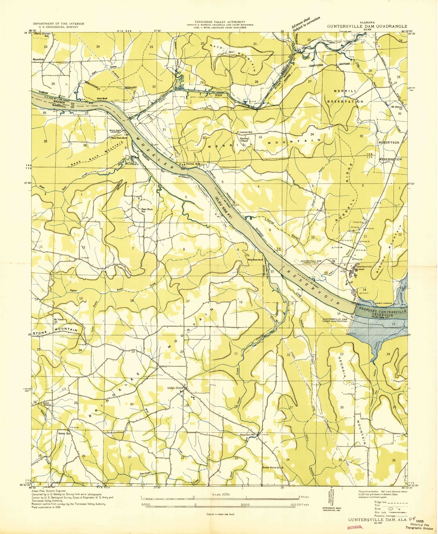
Historical USGS topographic quad map of Guntersville Dam in the state of Alabama. Typical map scale is 1:24,000, but may vary for certain years, if available. Print size: 24" x 27"
This quadrangle is in the following counties: Madison, Marshall.
The map contains contour lines, roads, rivers, towns, and lakes. Printed on high-quality waterproof paper with UV fade-resistant inks, and shipped rolled.
Contains the following named places: Bean Rock, Bean Rock Bluff, Bean Rock Creek, Bean Rock School, Beech Spring Cemetery, Benson Branch, Black Center, Black Mountain, Blue Rock Bluff, Bob Mountain, Boggess Cemetery, Cave Mountain, Clark Bluff, Clark Hollow, Cloud Cemetery, Cloud Mountain, Cotton Sinks, Daniel Spring, Fearn Branch, Georgia Mountain, Guntersville Dam, Guntersville Lake, Hambrick Hollow, Haney Mountain, Hebron, Hills Chapel, Little Paint Rock Creek, Long Hollow, Mayo Cemetery, Mayo Mountain, McDermott Mountain, Merrill Mountain, Merrill Reservation (historical), Mill Hollow, Morris Cemetery, Mount View Church, Nearen Cemetery, Neighbors Mill, Paint Rock River, Patterson Cemetery, Pea Ridge, Peachtree Creek, Perkins Hollow, Robertson Reservation (historical), Russell Ridge, Scott Branch, Shoal Creek, Snow Point, Stewart Hollow, Sugar Tree Hollow, Tacket Branch, Union Chapel Church, Union Grove, Vaughn Hollow, Wild Goat Cove, Wolf Creek, Allens Bar (historical), Bean Rock Ferry (historical), Bean Rock Landing (historical), Blue Rock Landing (historical), Coal Landing (historical), Coles Bend Bar (historical), Ferns Quarter (historical), Flat Rock School (historical), Fosters Landing (historical), Hebron School, Honey Ferry (historical), Honey Landing (historical), Lamont (historical), Paint Rock Landing (historical), Speers Landing (historical), Union Chapel Church, Upton (historical), Bloomfield (historical), Cloud Cove Church, Cloud School (historical), Sweet Home Cemetery, Cave Mountain Small Wild Area, Blowing Cave Spring, Ferguson Spring, Hines Cemetery, Johnson, Mobbs Church (historical), Union Grove Junior High School, Painted Bluff, Sweet Home Baptist Church, Beech Spring Church, Mount Hebron Baptist Church, Walker Cemetery, Mobbs School, Beech Spring, Parches Cove, Pigeon Roost Creek, Hebron Church, Union Grove Division, Liberty Grove School (historical), Guntersville Dam Landing Field (historical), Harding Chapel (historical), Lamont School (historical), Long Hollow Branch, Town of Union Grove, Martin Farm, Ferguson Farms, Union Grove Volunteer Fire Department, Hebron Volunteer Fire Department, Union Grove Post Office, Bean Rock, Bean Rock Bluff, Bean Rock Creek, Bean Rock School, Beech Spring Cemetery, Benson Branch, Black Center, Black Mountain, Blue Rock Bluff, Bob Mountain, Boggess Cemetery, Cave Mountain, Clark Bluff, Clark Hollow, Cloud Cemetery, Cloud Mountain, Cotton Sinks, Daniel Spring, Fearn Branch, Georgia Mountain, Guntersville Dam, Guntersville Lake, Hambrick Hollow, Haney Mountain, Hebron, Hills Chapel, Little Paint Rock Creek, Long Hollow, Mayo Cemetery, Mayo Mountain, McDermott Mountain, Merrill Mountain, Merrill Reservation (historical), Mill Hollow, Morris Cemetery, Mount View Church, Nearen Cemetery, Neighbors Mill, Paint Rock River, Patterson Cemetery, Pea Ridge, Peachtree Creek, Perkins Hollow, Robertson Reservation (historical), Russell Ridge, Scott Branch, Shoal Creek, Snow Point, Stewart Hollow, Sugar Tree Hollow, Tacket Branch, Union Chapel Church, Union Grove, Vaughn Hollow, Wild Goat Cove, Wolf Creek, Allens Bar (historical), Bean Rock Ferry (historical), Bean Rock Landing (historical), Blue Rock Landing (historical), Coal Landing (historical), Coles Bend Bar (historical), Ferns Quarter (historical), Flat Rock School (historical), Fosters Landing (historical), Hebron School, Honey Ferry (historical), Honey Landing (historical), Lamont (historical), Paint Rock Landing (historical), Speers Landing (historical), Union Chapel Church, Upton (historical), Bloomfield (historical), Cloud Cove Church, Cloud School (historical), Sweet Home Cemetery, Cave Mountain Small Wild Area, Blowing Cave Spring, Ferguson Spring, Hines Cemetery, Johnson, Mobbs Church (historical), Union Grove Junior High School, Painted Bluff, Sweet Home Baptist Church, Beech Spring Church, Mount Hebron Baptist Church, Walker Cemetery, Mobbs School, Beech Spring, Parches Cove, Pigeon Roost Creek, Hebron Church, Union Grove Division, Liberty Grove School (historical), Guntersville Dam Landing Field (historical), Harding Chapel (historical), Lamont School (historical), Long Hollow Branch, Town of Union Grove, Martin Farm, Ferguson Farms, Union Grove Volunteer Fire Department, Hebron Volunteer Fire Department, Union Grove Post Office